A wayside point near the Domaine du Sauvage. There may be a chapel or cross dedicated to Saint Roch, the patron saint of pilgrims and plague victims. No services.
A hamlet in the forest between the Domaine du Sauvage and Saint-Alban-sur-Limagnole. The path passes through on its gradual descent from the high Margeride. No services.
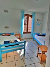
Accommodation in Le Rouget.
| Gîte et chambres d'hôtes à la Ferme La Croix du Plô 15€ 12 |
Saint-Alban is a small town in the Limagnole valley that serves as a welcome return to civilization after the remote Margeride crossing. You'll find basic services here: a grocery store, bakeries, restaurants, and accommodation options including gites and hotels. There's a pharmacy and post office.
The town is dominated by its Renaissance castle, originally a 12th-century fortress of the Lords of Apcher that was rebuilt in the 15th century. Today it houses the tourist office and hosts exhibitions in its courtyard. The town also has an unexpected claim to fame: its psychiatric hospital, founded in 1821, became the birthplace of institutional psychotherapy during World War II, when psychiatrists and resistance fighters sheltered patients from Vichy deportation policies.
Saint-Alban has a pleasant, unassuming character. It's a working town rather than a tourist destination, and pilgrims passing through are part of the rhythm rather than the main event.
The castle of Saint-Alban was held by the House of Apcher from the 13th century onward. The Marquis d'Apcher was the same nobleman who organized the final hunt for the Beast of Gevaudan in 1767.
During World War II, the psychiatric hospital at Saint-Alban became a center of resistance and radical innovation. When Vichy policies led to the starvation deaths of thousands of psychiatric patients across France, the doctors at Saint-Alban, including the Catalan exile Francois Tosquelles and communist psychiatrist Lucien Bonnafe, kept their patients alive through local farming networks and resistance connections. The hospital's death rate stayed below 10 percent while others lost more than 40 percent of their patients. This experience gave birth to institutional psychotherapy, a movement that transformed French mental health care.
From Saint-Alban, the path climbs back up to the plateau, heading south toward Aumont-Aubrac. The terrain is rolling and mostly gentle, crossing farmland and passing through a series of small hamlets. The landscape is transitional here: you're leaving the granite Margeride behind and approaching the volcanic Aubrac. The distance to Aumont-Aubrac is roughly 16 km.
Accommodation in Saint-Alban-sur-Limagnole.
| Gîte Les Souliers de Saint-Jacques 28€ 8 |
|
| Gîte d´étape Le Penote 15€ 4 |
|
| Gîte-hôtel du Centre 13€ 10 |
|
| Gîte d´étape L'Europe 15-20€ 19 |
|
| Gîte Aux amis dans le Chemin Donativo€ 8 |
|
| Gîte d´étape Le Gévaudan 30**€ 12 |
|
| Gîte Le Refuge du Pèlerin 20€ 12 |
|
| Gîte Antre Nous 17-20€ 11 |
A small hamlet on the path between Saint-Alban and Aumont-Aubrac. Stone houses, farmland, not much else. No services.
Accommodation in Grazières-Mages.
| Camping Le Galier *** 10-15€ |
A scattering of farm buildings on the open plateau between Saint-Alban and Aumont-Aubrac. No services. The walking is easy across gently rolling terrain.
A small hamlet on the road south toward Aumont-Aubrac. No services. You're crossing quiet farming country, with the terrain gradually shifting from Margeride granite to the volcanic soils of the Aubrac.
A farming hamlet on the approach to Aumont-Aubrac. No services, but you're getting close to town now.
Accommodation in Bigose.
| Gîte-hôtel Les Granges de Bigose 40**€ 10 Booking.com |

|
The last hamlet before Aumont-Aubrac. A few houses along the road. No services, but Aumont-Aubrac is just ahead.
Aumont-Aubrac sits on the N9 highway at the northern edge of the Aubrac plateau and marks the transition between the Margeride granite country you've been crossing and the volcanic Aubrac that lies ahead. It's a small but well-serviced town with everything you need: supermarket, bakeries, butcher, restaurants, pharmacy, ATM, and a post office.
The town's most notable building is the Eglise Saint-Etienne, a fortified church with a robust bell tower that reflects the region's history of conflict. There's also a pleasant town square where pilgrims gather in the evenings.
Several gites and hotels cater to the steady flow of pilgrims passing through. Aumont-Aubrac is the last town with full services before the Aubrac crossing, so this is the place to resupply. Buy food for the next stretch, check the weather forecast, and make sure your gear is in order.
If you arrive on a Wednesday, you'll catch the weekly market.
This is your last chance for full services before the Aubrac plateau. The next town with shops is Nasbinals, roughly 27 km south. Between here and there, services are sparse to nonexistent. Check the weather before setting out: the Aubrac is exposed and conditions can change rapidly.
Aumont was historically a staging post on the old Roman road that crossed the Aubrac. The Penitents had a chapel here, and the fortified church reflects centuries of insecurity in this borderland between the Gevaudan and the Rouergue. The town took the suffix "Aubrac" in 1962 to capitalize on the growing reputation of the plateau for tourism and gastronomy.
Market day is Wednesday morning. The town hosts occasional agricultural fairs tied to the pastoral calendar of the Aubrac.
From Aumont-Aubrac the path heads south, climbing gently onto the Aubrac plateau. The landscape opens dramatically as you leave the town. You're entering a high volcanic plateau that averages about 1,200 m in elevation, characterized by vast open pastures, scattered granite boulders, dry stone walls, and the long transhumance paths called drailles that have been used to move cattle for centuries.
The terrain is gently rolling but exposed. There's minimal tree cover and the wind can be fierce. In good weather, the views are enormous: green pastures stretching to every horizon, dotted with the rust-colored Aubrac cattle that are as much a part of the landscape as the stone walls. In bad weather, it's a different story entirely.
Accommodation in Aumont-Aubrac.
| Gîte d´étape Les Sentiers Fleuris 25+€ 20 |
|
| Gîte d´étape Chemin Faisant 17€ 14 |
|
| Gîte La Ferme de l'Aubrac-Aubrac Hôtel 12€ 14 Booking.com |

|
| Gîte d´étape Ferme du Barry 15+€ 36 |
|
| Gîte d´étape Route d'Aubrac 12+€ |
A tiny village a few kilometers south of Aumont-Aubrac on the edge of the Aubrac plateau. There's a small Romanesque church. You may find a gite or chambre d'hote here; check locally. The village sits on the transition between Margeride and Aubrac.
The path continues south across increasingly open terrain. The trees thin out and the landscape becomes the characteristic Aubrac: wide pastures, stone walls, wind.
A point on the path across the Aubrac plateau. Pine trees give the spot its name. No services.
A hamlet on the Aubrac plateau between Aumont-Aubrac and Nasbinals. A few farm buildings in a vast landscape. No services.
Accommodation in Lasbros.
| Gîte Chez Marie en Aubrac 22€ 14 |
A crossroads on the Aubrac plateau where four paths meet. The name says it all. No services, no settlement to speak of, just a junction in open country. A good place to check your navigation if visibility is poor.
Accommodation in Les Quatre-Chemins.
| Gîte d´étape Aux Quatre Vents 40**€ 13 |
|
| Gîte d'étape Les 4 Chemins en Aubrac 40**€ 15 |
A farm hamlet on the Aubrac plateau. Stone buildings, cattle, and not much else. No services.
A small hamlet on the Aubrac between Les Quatre-Chemins and Rieutort-d'Aubrac. The landscape is open and exposed, classic high Aubrac. No services.
Accommodation in Finieyrols.
| Gîte et chambres d'hôtes La Rose de l'Aubrac 20€ 6 |
|
| Gîte et chambres d'hôtes Les Gentianes 38**€ 26 |
A small village on the Aubrac plateau that offers a welcome break in the long stretch between Aumont-Aubrac and Nasbinals. There's a gite d'etape here and possibly a small bar or restaurant in season. The village sits on the Rieu Tort stream, whose name means "twisted stream" in Occitan.
The Romanesque church is worth a glance. Rieutort provides an intermediate stopping option for those who don't want to push all the way to Nasbinals in one go.
From Rieutort the path continues south across the Aubrac plateau toward Nasbinals, roughly 10 km away. The terrain remains open and gently rolling. Montgros, the last hamlet before Nasbinals, is about halfway.
A tiny hamlet on the Aubrac plateau, the last settlement before Nasbinals. A few stone farm buildings. No services, but Nasbinals is only about 5 km ahead.
Accommodation in Montgros.
| Gîte-hôtel La Maison de Rosalie 45**€ 14 |
Nasbinals is the gateway to the high Aubrac and the last town before the exposed plateau crossing to Aubrac village and beyond. It's a small but lively place, built in the dark basalt stone that characterizes the Aubrac, with a population of around 500 that swells considerably during walking season.
The Eglise Sainte-Marie is the star of the village: an 11th-century Romanesque church built of local basalt and granite, with an octagonal bell tower and beautifully carved capitals inside. It's one of the finest small Romanesque churches on the entire Via Podiensis and worth a long look.
The village has hotels, gites, restaurants, a bakery, a butcher, a grocery store, and a tourist office. This is Aubrac country, and the local cuisine reflects it: aligot (mashed potato whipped with fresh tome cheese until it stretches in long, elastic ribbons) is the signature dish and is served everywhere. The beef comes from the distinctive Aubrac cattle, and the local restaurants take pride in their terroir.
A bronze statue in the village garden commemorates Pierre Brioude, known as "Pierrounet," a local bonesetter who died in 1907 and whose reputation for healing broken limbs drew people from across the region.
Resupply here. The next services are in Aubrac village, a tiny settlement 17 km to the south, or Saint-Chely-d'Aubrac beyond that.
The crossing from Nasbinals to Saint-Chely-d'Aubrac via the village of Aubrac covers some of the most exposed terrain on the Via Podiensis. The plateau reaches over 1,300 m and is completely open to the elements. In good weather, it's magnificent. In fog, rain, or snow, it can be dangerous. Check the forecast before setting out, and if conditions are bad, wait. The Aubrac has claimed lives.
The village has been a stopping point for pilgrims since the medieval period. The Eglise Sainte-Marie dates from the late 11th century and is a pure example of Auvergne Romanesque architecture, with its heavy basalt walls and the octagonal tower typical of the region.
Nasbinals sits at the northern edge of the Aubrac massif, a volcanic plateau formed 5 to 9 million years ago. The plateau's basalt overlies a much older granite basement, and this geology defines everything about the landscape: the dark stone buildings, the rich volcanic soil that supports the pastures, and the burons, the traditional stone shelters where shepherds spent the summer making cheese during the transhumance.
The transhumance, the annual movement of cattle to summer pastures, traditionally begins on May 25 (the feast of Saint Urban). The cattle are decorated with flowers and bells and paraded up to the high pastures in a celebration that draws crowds. It's one of the great living agricultural traditions of France.
From Nasbinals you climb south onto the high Aubrac plateau. The path follows ancient drailles, the stone-walled transhumance paths, across a landscape that has barely changed in centuries. The Aubrac cattle graze on either side, and in spring and early summer the pastures are carpeted with wildflowers.
The route climbs to over 1,300 m before reaching the tiny village of Aubrac, where a medieval hospital once sheltered pilgrims making this same crossing. The terrain is gentle but utterly exposed. There are no trees, no shelter, and no services between Nasbinals and Aubrac village. Carry water and be prepared for rapid weather changes.
Accommodation in Nasbinals.
| Gîte communal de Nasbinals 12-15€ 19 |
| Gîte centre équestre des monts d'Aubrac 40**€ 22 |
|
| Gîte d´étape Au bon repos du Pélerin 15€ 5 |
|
| Gîte et chambres d'hôtes Lô D'ici 30€ 20 |
|
| Gîte d´étape La Grappière 20€ 15 |
|
| Gîte d´étape Lo Fenador 13€ 10 |
| Gîte d´étape de l'association NADA 12€ 38 |
| Gîte d´étape Le Sorbier 16€ 20 |
The village of Aubrac is barely a village at all. A handful of stone buildings at about 1,300 m on the open plateau, clustered around the remains of a medieval monastery that once gave shelter to pilgrims exactly like you. In bad weather, this is one of the loneliest spots in France. In good weather, the views across the high pastures are endless.
The Domerie d'Aubrac was founded in 1120 by Adalard, a Flemish viscount, after he was attacked by bandits during his own pilgrimage to Santiago. He vowed to build a hospital on this exposed plateau so that future pilgrims wouldn't suffer as he had. At its height, the domerie sheltered thousands of pilgrims each year and rang a bell through the night to guide lost travelers in fog and snow. The bell was called "La Perdude" -- the bell for the lost.
Today you can still see the Tour des Anglais (a 13th-century defensive tower), the church, and parts of the monastery buildings. There's a gite d'etape and a restaurant. The atmosphere is austere and quietly moving. You're standing where pilgrims have stood for 900 years, on one of the wildest and most remote stretches of the entire Santiago route.
The Domerie d'Aubrac was one of the most important pilgrim hospitals in medieval France. Founded in 1120, it grew into a vast complex that included a hospital, a church, a hospice, and a community of monks, nuns, and lay brothers called "domins" who lived under a semi-religious rule. They were responsible for maintaining the road, sheltering pilgrims, and ringing the bell through storms and fog.
The domerie was also a significant landholder, controlling much of the surrounding plateau and its pastoral economy. It survived until the Revolution, when it was dissolved and its properties sold. Most of the original buildings were demolished for their stone. What remains -- the tower, the church, and a few structures -- gives only a faint impression of what was once a remarkable institution.
From Aubrac, the path begins a long, gradual descent off the plateau toward the Lot valley. The landscape transitions from open pasture to scattered woodland and then into the steep-sided Boralde valley. The descent to Saint-Chely-d'Aubrac covers about 17 km and drops roughly 600 m. The first section across the plateau is easy, but as you drop into the valley, the path becomes steeper and more wooded.
Accommodation in Aubrac.
| Gîte d´etape communal La Tour des Anglais 10€ 16 |
A tiny hamlet on the Aubrac plateau between the village of Aubrac and the descent to Saint-Chely. Open pastures, cattle, stone walls. No services.
A farming hamlet on the edge of the Aubrac plateau. The terrain begins to change here as you start the descent toward the Boralde valley and Saint-Chely-d'Aubrac. No services.
Accommodation in Sarbonnel.
| Gîte et chambres d'hôtes Sarbonnel 14€ 6 |
Saint-Chely sits in the Boralde valley at the foot of the Aubrac plateau, and the contrast with the high pastures above is immediate. You've dropped from open grassland into a green, wooded valley with a village of stone houses along a stream.
The village has gites, a hotel or two, restaurants, and basic supplies. The 16th-century Pont des Pelerins (Pilgrims' Bridge) over the Boralde is a single elegant arch that has carried pilgrims across this stream for 500 years. It's a small bridge, but it's a genuine medieval pilgrim structure and worth pausing on.
The Romanesque church has been modified over the centuries but retains its original proportions. In the village you may notice carved scallop shells on door lintels, a reminder that this has been pilgrim country for a very long time.
The village's name derives from Saint Eligius (Saint Eloi in French, "Chely" in local dialect), the 7th-century bishop and goldsmith. The Pont des Pelerins dates from the early 16th century and is part of the UNESCO World Heritage listing for the Routes of Santiago de Compostela in France.
From Saint-Chely the path follows the Boralde valley south, gradually descending through woodland and farmland toward the Lot valley. The terrain is gentle and shaded after the exposed Aubrac. You'll pass through several small hamlets before reaching Saint-Come-d'Olt on the banks of the Lot.
Accommodation in Saint-Chély-d'Aubrac.
| Gîte d´étape communal Chez Fanny et Jérémy 16€ 26 |
| Gîte d´étape Saint-André 20€ 20 |
|
| Gîte et chambres d'hôtes La Tour des Chapelains 220€ 6 |
|
| Gîte et chambre d'hôtes Relais Saint-Jacques 38**€ 9 |
A hamlet in the Boralde valley between Saint-Chely-d'Aubrac and the Lot. Surrounded by woodland and pasture. No services.
A small settlement in the valley between Saint-Chely and Saint-Come-d'Olt. The path passes through on its descent toward the Lot river. No services.
Accommodation in Lestrade.
| Gîte d´étape de Lestrade 38**€ 17 |
A hamlet in the lower Boralde valley as the path approaches the Lot. No services. The landscape is becoming greener and more enclosed after the open Aubrac.
A small hamlet near Saint-Come-d'Olt. The name means "five stones" in Occitan. No services, but you're close to town.
Saint-Come-d'Olt is classified among the Plus Beaux Villages de France, and for good reason. This medieval town sits in a loop of the Lot river (Olt is the Occitan name for the Lot) and has preserved its circular plan, three fortified gates, and Renaissance houses remarkably intact.
The most distinctive feature is the bell tower of the Eglise Saint-Come-et-Saint-Damien, which has a famous "twisted" or flame-shaped spire. How and why it twists is debated -- some say it's a deliberate decorative choice, others blame warped timbers. Either way, it's unmistakable.
The narrow streets are a pleasure to wander. Look for the Renaissance-era Chateau des Sires de Calmont, the carved doorways and window frames, and the overall sense of a town that hasn't changed much since the 16th century. There are gites, chambres d'hotes, and a couple of restaurants. Basic supplies are available.
The town grew around a Benedictine priory and was fortified during the Hundred Years' War. The three surviving gates -- Porte de la Barriere, Porte du Theron, and Porte Neuve -- date from this period. The church was rebuilt in the 16th century, and its twisted spire has been a landmark ever since. Saint-Come-d'Olt was one of the earliest villages to be classified among the Plus Beaux Villages de France.
From Saint-Come-d'Olt the path follows the north bank of the Lot river downstream toward Espalion, about 5 km away. This is easy, flat walking along the river, a welcome change after the Aubrac descent. The Lot valley is wide and fertile here, with vineyards and orchards on the slopes above.
Accommodation in Saint-Côme-d'Olt.
| Gîte del Roumiou 20€ 18 |
| Gîte d´étape l'Antidote 20€ 8 |
|
| Gîte d´étape Halte d'Olt 15€ 8 |
|
| Gîte et chambres d'hôtes Les Jardins d'Eliane 39**€ 12 |
|
| Gîte Le Chat en Boule 6 |
| Hôtellerie du Couvent de Malet - Espace Angèle Mérici 19€ 70 Booking.com |

|
Espalion is the largest town you'll have encountered since Le Puy-en-Velay, and it has everything you need: supermarkets, banks, pharmacy, doctors, post office, outdoor shops, and a good selection of restaurants and accommodation. It sits on both banks of the Lot river, which runs green and clear through the center of town.
The Pont Vieux, a graceful 11th-century bridge of pink sandstone, is the centerpiece of the town and is inscribed on the UNESCO World Heritage list as part of the Santiago routes in France. The old tannery buildings along the riverbank below the bridge, with their wooden balconies overhanging the water, are distinctive to Espalion and give the town its particular character.
On the south bank, the Vieux Palais is a Renaissance building with defensive towers overlooking the Lot. The Eglise Saint-Jean-Baptiste, built in red sandstone, dates from the 15th century.
Take the time to resupply here. The section ahead through the hills to Conques has limited services.
Espalion grew as a crossing point on the Lot and as a market town for the surrounding agricultural region. The Pont Vieux dates from the 11th century and has been in continuous use since its construction. The tanning industry that gave the town its distinctive riverside buildings was active from the medieval period into the 20th century. The Musee Joseph Vaylet in the former church of Saint John houses a collection of local arts and traditions.
Market day is Tuesday. The Fete de l'Espalionnais in early August features local food, music, and events.
From Espalion the GR65 heads south along the Lot toward Bessuéjouls and then Estaing. The walking is pleasant, following the river valley through gentle countryside. Estaing is about 11 km away.
Accommodation in Espalion.
| Gîte d´étape Au Fil de l'Eau 17-20€ 15 |
|
| Gîte d´étape du Pont Vieux 17€ 12 |
|
| Gîte d´étape La Halte Saint Jacques 20€ 18 Booking.com |
|
A small village between Espalion and Estaing with a notable Romanesque chapel. The Chapelle Saint-Pierre de Bessuéjouls, attached to the parish church, has early Romanesque carved capitals that are considered some of the finest in the Rouergue. If you have an interest in Romanesque art, it's worth a look. Otherwise, there are no real services here.
The Chapelle Saint-Pierre dates from the 11th century and its carved capitals depict biblical scenes with a distinctive local style. The church was a dependency of the abbey of Conques.
Accommodation in Bessuéjouls.
| Gîte et chambres d'hôtes Domaine d'Armagnac 25€ 8 |
A hamlet on the path between Espalion and Estaing. The route follows the Lot valley, which narrows as you head south. No services.
Estaing is one of the Plus Beaux Villages de France, and it earns the title. The village is draped across a hillside above a bend in the Lot river, dominated by its massive castle and connected by a beautiful Gothic bridge that, like the Pont Vieux in Espalion, is UNESCO-listed as part of the Santiago routes.
The castle of the Estaing family looms over the village. This was the seat of one of the most illustrious noble families in France, whose members include a bishop of Clermont, an admiral of France, and most recently Valery Giscard d'Estaing, President of the Republic from 1974 to 1981, who bought back the family castle in 2005.
The village itself is compact and walkable: steep lanes, stone houses with slate roofs, a 15th-century church, and the bridge, which dates from the late 15th century and features a statue of a pilgrim at its midpoint. There are gites, hotels, restaurants, and basic supplies.
A small pilgrim festival is held in early July around the Feast of Saint Fleuret, the village's patron saint.
The Estaing family traces its lineage to the 11th century and held the lordship here for over 500 years. The castle was confiscated during the Revolution, served as various public buildings, and was finally repurchased by Valery Giscard d'Estaing, who later donated it to a foundation. The Gothic bridge was built in the late 15th century to serve the growing pilgrim traffic on the Via Podiensis.
The Fete de Saint-Fleuret in early July is a religious and civic celebration with a procession carrying the relics of the patron saint through the village streets. Market day varies seasonally.
Leaving Estaing, the path climbs steeply out of the Lot valley. You're leaving the river behind and entering a stretch of rolling ridge country that will carry you to Conques. The climbing is sustained for the first few kilometers but the terrain is varied, with forest, farmland, and long views from the ridgetops. Golinhac, the next village with services, is about 14 km ahead.
Accommodation in Estaing.
| Gîte d´étape communal de Estaing 17€ 22 |
| Gîte Chez Aurelie 16€ 8 |
|
| Au Paradis sur Terre 15€ 14 |
|
| Gîte Haut-Doubs d'Estaing 17+€ 6 |
|
| Gîte Les Pieds dans l'Olt 16€ 18 |
|
| Gîte d´étape Saint-Christophe 17€ 15 |
A hamlet on the climb out of the Lot valley after Estaing. The path rises steeply through woodland. No services.
A farming hamlet on the ridge between the Lot valley and Golinhac. No services.
Accommodation in Fonteilles.
| Gîte et chambres d'hôtes de Fonteilles Lo Soulenquo 17-22€ 22 Booking.com |

|
A small hamlet along the ridge path. Open farmland with long views. No services.
A hamlet on the approach to Golinhac. A few stone farmhouses. No services, but Golinhac is close.
Accommodation in Massip.
| Gîte d´étape l'Orée du Chemin 15€ 20 |
A small ridge-top village with a church and a handful of houses, sitting at about 630 m with views across the valleys on either side. Golinhac has a gite d'etape, possibly a small restaurant or bar in season, and represents the main stopping option between Estaing and Conques.
The Romanesque church is simple but well-proportioned. The village has a quiet, agricultural character and sees few visitors outside of the pilgrim flow.
From Golinhac the path continues south along the ridges toward Espeyrac and eventually Conques. The terrain is rolling, with gradual climbs and descents through farmland and forest. It's pleasant walking through a landscape of small farms and scattered hamlets.
Accommodation in Golinhac.
| Gîte Le Petit Saint-Jacques et chambres La Landette 41**€ |
|
| Pôle touristique Bellevue 15€ 31 |
A hamlet on the ridge path between Golinhac and Espeyrac. No services.
A small farming hamlet on the ridge. No services.
A hamlet in the rolling countryside between Golinhac and Espeyrac. No services.
A farming hamlet on the approach to Espeyrac. No services.
Accommodation in Le Soulié.
| Accueil au Soulié de Saint Jacques Donativo€ 14 |
A small village in a valley between the ridges, with a church, a handful of stone houses, and a gite d'etape. It's a peaceful place with minimal services but makes for a quiet overnight stop if you don't want to push all the way to Conques in one go. The medieval bridge at the bottom of the village is worth noting.
From Espeyrac the path climbs back up to the ridge, passing through Senergues before beginning the famous descent into Conques. The terrain is hilly but not extreme.
Accommodation in Espeyrac.
| Gîte d´étape communal de Espeyrac 15€ 12 |
| Gîte d´étape Chez Benjamine 15-20€ 4 |
A village on the ridge above the Dourdou valley, with a castle, a church, and a few gites. Senergues has more substance than most of the hamlets you've passed through recently. The castle dates from the 15th century and dominates the village. There's accommodation and possibly food in season.
From here, you're roughly 8 km from Conques, and the descent into the valley is ahead of you.
The path descends from Senergues toward the hamlet of Saint-Marcel before beginning the final approach to Conques. The famous first view of Conques, emerging suddenly through the trees as you descend into the Ouche valley, is one of the great moments on the Via Podiensis.
Accommodation in Sénergues.
| Gîte d´étape Domaine de Sénos 18€ 33 |
|
| Gîte L'Oustalet 25*€ 6 |
|
| Gîte d´étape Ginette et Maurice 25*€ 6 |
A hamlet on the plateau above the Ouche gorge, the last settlement before Conques. In the medieval period, its priory was a dependency of the abbey of Conques below. There's a rest area here for pilgrims. No other services.
The descent from Saint-Marcel into Conques is steep and dramatic. Take it slowly and savor the anticipation.
The path drops steeply into the Ouche valley. At some point through the trees, you'll catch your first glimpse of Conques below: the slate roofs, the massive abbey church, the village clinging to the hillside. It's a sight that has stopped pilgrims in their tracks for a thousand years.
Conques is the emotional high point of the Via Podiensis. This tiny medieval village clings to a steep hillside above the Ouche river, its grey schist houses topped with heavy lauze stone roofs that catch the light and change color through the day. At its heart stands one of the great Romanesque churches of Europe.
The Abbatiale Sainte-Foy dominates everything. The tympanum above the west door depicts the Last Judgment in extraordinary detail: Christ sits in judgment, the blessed process calmly to their reward on the left, while the damned are dragged into a chaotic hell on the right. Spend time with it. The carving is vivid, violent, and blackly humorous in places. It was meant to terrify medieval pilgrims into good behavior, and it still has power.
Inside, the church is vast for such a small village, a three-aisled basilica with a barrel vault, ambulatory, and radiating chapels designed to handle crowds of pilgrims. The modern stained glass windows by Pierre Soulages, installed between 1987 and 1994, are a controversial addition: translucent panels that filter the light without color, creating an austere glow that divides opinion. Some find them revelatory, others mourn the loss of traditional glass. Form your own view.
The Treasury houses the Reliquary of Sainte Foy, a 9th-century gold and jewel-encrusted statue that is one of the oldest surviving reliquary statues in Europe. The saint herself was a young girl martyred in the 3rd century whose relics were famously stolen from Agen by monks from Conques in 866. The theft made the village's fortune.
The village streets are narrow and steep, cobbled in local schist. As the local saying goes, "In Conques, you enter through the attic and leave through the cellar." There are gites, hotels, restaurants, and a couple of shops. Book ahead in summer. The village is small and popular, and accommodation fills quickly.
Give yourself at least a full evening here, preferably a morning as well. Walk the streets after the day-trippers leave. The village is different at dusk and dawn, when the stone turns gold and the only sound is the river below.
The village is car-free in the center. Accommodation is limited, so book ahead in the May-September walking season. The descent into Conques from the north is steep and can be slippery when wet. Take care on the schist cobbles in the village itself.
Conques became a major pilgrimage center after the audacious theft of the relics of Sainte Foy from Agen in 866. A monk named Ariviscus spent ten years embedded in the Agen monastery before making off with the bones. The relics attracted pilgrims by the thousands, and the abbey grew wealthy from their donations.
The current church was built between 1041 and 1107 to accommodate the pilgrim traffic and is one of the finest surviving examples of the Romanesque "pilgrimage church" plan. Its layout, with ambulatory and radiating chapels allowing pilgrims to circulate around the relics without disrupting services, is directly related to Santiago de Compostela and the other great pilgrimage churches of the era.
The village declined after the medieval period and was nearly abandoned. It was rediscovered by the writer Prosper Merimee in the 19th century, who campaigned for its preservation. The restoration work has been ongoing ever since, and Conques was among the first villages classified as Plus Beaux Villages de France.
The Fete de Sainte Foy is celebrated on October 6. A lumiere show illuminates the tympanum on summer evenings, bringing the carved figures to life with projected color. The Conques festival of European music takes place in summer with concerts in the abbey.
From Conques the path crosses the Dourdou river and climbs steeply out of the valley on the other side. The ascent is significant, gaining about 350 m in the first 3 km. You're heading south toward the industrial town of Decazeville and then Figeac. The character of the landscape changes: you're leaving the deep valleys of the Rouergue and entering the rolling causse country of the Lot.
Accommodation in Conques.
| Accueil Abbaye de Sainte-Foy 12€ 45 |
| Chambre d'hôtes L'Alcôve |
Noailhac is a small hamlet about 8 km from Conques on the GR6 variant, the route most pilgrims prefer because it avoids 5 km of departmental road on the official GR65. There's a gite d'etape in an old farmhouse where communal dinners are available, and a bar-restaurant with an expansive view over the surrounding hills. If you're doing the Conques-to-Livinhac stage in one go, this is a good place to rest and refuel before the longer stretch ahead.
From Conques, the path descends Rue Charlemagne, passes through the Porte du Barry, and crosses the 15th-century stone bridge over the Dourdou river. Then the climbing begins. You'll gain about 200 m on a steep, rocky footpath through lush vegetation in the first kilometer alone. The old saying captures it well: the descent into Conques is perilous and the climb out is painful.
At the Chapelle Sainte-Foy, where legend says a spring appeared after a monk struck the rock with his staff, the gradient eases. You'll reach the fork where the GR65 continues along the road and the GR6 variant heads right through forest and pasture. The variant is 2 km longer but far more pleasant. The two routes rejoin at Fonteilles after about 8.5 km.
Accommodation in Noailhac.
| Gîte d´étape communal de Noailhac 12€ 18 |
A pair of hamlets on the route between the Conques climb and Decazeville. You're in a transitional landscape here, moving through patches of forest and open pasture as the path winds along the ridgeline. No services.
A small settlement on the descent toward the Decazeville basin. The countryside begins to change character here as you leave the forested hills and approach the industrial valley below. No services.
Accommodation in Vivioles.
| Éco-gîte du Mineur Paysan 14-20€ 14 |
Decazeville sits at 207 m in a valley that was once one of France's major coal-producing centers. It's a functional town rather than a pretty one, but it has all the services you might need: a supermarket, pharmacy, post office, and several accommodation options including the gite d'etape Les Volets Bleus, which has English-speaking hosts and sits right on the GR65.
If you stop for only one thing, make it the church. The Eglise Notre-Dame houses 14 Stations of the Cross painted by Gustave Moreau in 1863, the only Symbolist Stations of the Cross in the world. Moreau painted them anonymously during a period when he was deeply influenced by Italian Renaissance color. Each canvas was completed in just three or four days, with sparse, minimal compositions showing only the essential figures. The paintings hung forgotten for a century until Gilbert Bou rediscovered them in 1964. They were classified as a Historical Monument the following year. Marcel Proust mentioned them in his novel Jean Santeuil.
A ridge path option allows you to bypass Decazeville entirely, saving about a kilometer. But you'd miss the Moreau paintings, and those are worth the detour.
The town takes its name from Duke Elie Decazes, president of ministers under Louis XVIII. The original village was called La Salle, and coal had been mined here since the 16th century. In 1826, Decazes partnered with engineer Cabrol to found the Houilleres et Fonderies de l'Aveyron, and the town grew rapidly around mine shafts and factories. By 1834 it had a population of 2,715 and was established as its own commune. Under Napoleon III, it was officially named Decazeville.
At its peak in the early 1900s, over 9,000 workers were employed in coal, steel, zinc, glass, and brick production. La Decouverte, France's largest open-cast coal mine, operated from 1892 to 2001. The pit was 3.7 km long and 2.5 km wide. It's been rehabilitated as a public site with walking trails and heritage signage tracing the history of the mining era.
From the descent into Decazeville, the route crosses the valley floor and begins a steep, dry climb to the Chapelle Saint-Roch at 346 m. From there it's a rolling descent to Livinhac-le-Haut on the Lot river.
Accommodation in Decazeville.
| Gîte d´étape Les Volets Bleus 14-17€ 18 |
The Chapelle Saint-Roch sits on the ridge between Decazeville and Livinhac-le-Haut at 346 m. Built in 1785, it was constructed so that local parishioners wouldn't have to cross the Lot river to attend services in Livinhac. The door is topped by a cross, and inside there are two contemporary stained-glass windows by master glassmaker Victor Loup Deniau. Before the chapel was built, this was already a relay point for travelers.
Accommodation in Saint-Roch.
| Gîte d´étape Le Chemin 16€ 10 |
Livinhac-le-Haut is a quiet village sitting in a meander of the Lot river at about 200 m elevation. Historically known as the garden of the Aveyron for its fertile riverside fields, it was a center for vegetable and horticultural production. The village's 19th-century suspension bridge dates from the era when Decazeville's coal industry was booming.
Over 13,000 walkers pass through each year on the GR65, and the village has earned the Communes Haltes label for its commitment to pilgrim hospitality. Under the church you'll find the salle des pelerins, a sheltered rest hall open daily from March to October, 9 am to 6 pm, where you can eat, rest, and pick up local information.
Services are modest but sufficient: about 20 shops including a bakery, a communal gite with two-bed rooms, and a restaurant at the town hall serving regional dishes.
From Livinhac the first 2 km are on asphalt, then the path shifts to mixed earth tracks. You'll climb through woods and countryside toward Montredon, the highest point of this stretch, on slopes of about 10% through Perols and Feydel-le-Haut. The trails are shaded by chestnuts and oaks, pleasant walking when it's dry but often muddy after rain.
Accommodation in Livinhac-le-Haut.
Montredon sits on the highest point between Livinhac and Figeac. The name means the rounded mountain, and the village is dominated by the Eglise Saint-Michel. This is where the GR65 crosses from the Aveyron department into the Lot.
Just outside the village stands the Croix des Trois Eveques, the Cross of the Three Bishops. It marks the intersection of three old provinces: Quercy, Rouergue, and Auvergne, now the junction of the Lot, Aveyron, and Cantal departments. The cross commemorates the Council of the Three Border Dioceses held in 590, and according to legend, three bishops shook hands while each remained standing in his own diocese. The original cross, documented from 1238, was a modest 80 cm. The current version was reconstructed in 2013 by three neighboring municipalities.
Accommodation in Montredon.
| Accueil pèlerin La Mariotte 46-56**€ 12 |
|
| Halte pèlerin Le Saint-Michel 14€ 10 |
A small hamlet between Montredon and Guirande. You're on the descent now, passing through a landscape of oaks, chestnuts, and scattered caselles, the dry-stone shepherd shelters that are characteristic of this part of the Lot. No services.
Accommodation in Lacoste.
| Gîte Lacoste 20-30€ 3 |
Guirande is worth a pause. The 12th- to 13th-century chapel has remarkable wall paintings from the 16th century, and a magnificent iron cross stands beneath the large oaks outside.
Just past the chapel, the Etang de Guirande is one of those quiet places that stays with you. The path crosses the pond on a low, sometimes-floodable walkway. The water is still, the only sound the occasional cry of a wild duck. After days of walking, a place like this lands differently.
A wayside hamlet between Guirande and the approach to Figeac. The path continues through rolling terrain of woods and pasture. No services.
A small hamlet on the path toward Figeac. The terrain is opening up, and you're beginning the transition from the granite Segala plateau to the limestone country of the Limargue. The change shows in the soil, the vegetation, and the building stone. No services.
A hamlet on the approach to Figeac. You're firmly in limestone country now, with the fertile Limargue stretching ahead. No services.
Saint-Felix has a Romanesque church, Sainte-Radegonde, with an 11th-century tympanum depicting Adam and Eve. It's a small detail that's easy to walk past, but if you stop to look, the carving is remarkably expressive for its age.
A small commune in the Lot department on the GR65 approach to Figeac. The path here is beginning its descent toward the Cele valley. No services.
The name means the raised stone, suggesting a prehistoric megalith once stood here. You're on the final approach to Figeac now, and the descent is beginning to steepen. No services.
Accommodation in La Pierre Levee.
| Gîte d´étape Le Relais de la Bourrache 20*€ 4 |
The last hamlet before Figeac. The descent gets serious here, dropping at 10 to 20 percent through dense forest. You'll reach the railroad tracks and then follow the long, flat Avenue Victor Hugo into the city center.
Figeac is the first real city you've encountered since Le Puy-en-Velay, and after days of hamlets and tiny villages, it can feel almost overwhelming. Take your time. This medieval merchant town on the River Cele is one of the genuine highlights of the route, and it deserves at least a half-day of wandering.
Start with the architecture. Figeac's medieval center is remarkably intact, and its defining feature is the soleilho: open covered galleries under the rooftops where merchants dried cloth, skins, and fruit. The best examples line Rue de Balene and Rue Caviale, where 14th- and 15th-century houses still have their original wooden galleries, timber frames, and stone carvings. At street level, medieval arcades frame the shopfronts. The whole center is classified as a Ville d'Art et d'Histoire.
The town's most famous son is Jean-Francois Champollion, who was born here in 1790 and went on to crack the code of Egyptian hieroglyphics. The Musee Champollion occupies his birthplace on Place Champollion, its facade covered with 1,000 letters from writing systems around the world. The museum explores 5,000 years of human written communication, not just Champollion's Egyptian work. Behind the museum, the Place des Ecritures is a courtyard floored with an 11-by-8-meter reproduction of the Rosetta Stone in black granite, created by American artist Joseph Kosuth in 1991 for the bicentenary of Champollion's birth.
The Eglise Saint-Sauveur is the last remnant of the Benedictine abbey founded in 838. Its Romanesque nave dates to the 11th and 12th centuries, with a Gothic transept and choir added in the 13th. Climb the hill to Notre-Dame-du-Puy for panoramic views over the city's red tile roofs and the Cele valley.
Other sights worth your time: the Knights Templar Commandery on Rue Gambetta, a 13th-century complex where pilgrims were sheltered and fed, now open for self-guided tours in English; the Hotel de la Monnaie on Place Vival, a 13th-century merchant mansion that houses the tourist office; and the Aiguilles, large octagonal stone obelisks that once marked the boundaries of the abbey's territory.
The Saturday market at Place Carnot and Place Champollion is one of the best on the route. Quality Quercy produce: seasonal fruit, saffron, cheese, lamb. It covers most of the center.
Full services: supermarkets, banks, ATMs, pharmacies, hospital, doctors, post office. The train station has connections to Brive, Toulouse, Aurillac, and Rodez, plus a night train to Paris-Austerlitz. Wide range of accommodation from gites to hotels.
According to legend, King Pepin the Short founded a monastery here in 753 after witnessing pigeons flying in the shape of a cross. The historical record begins more solidly in 838, when Benedictine monks from Conques established the Abbey Saint-Sauveur. The town grew around the abbey.
In 1096, Pope Urban II attached Figeac's abbey to Cluny, resolving a longstanding rivalry with Conques. By the 12th century, Figeac was a flourishing trade city and an established stop on the Way of Saint James. The Knights Templar set up a commandery in 1187. In 1302, King Philippe IV granted Figeac the privilege of minting money.
The 13th and 14th centuries were the peak of prosperity. International trade in luxury goods brought wealth that merchants poured into the ornate mansions you can still see in the old town. The Hundred Years' War brought mercenary bands, and in 1576, Protestants took Figeac during the Wars of Religion, destroying abbey relics, artworks, and buildings.
Jean-Francois Champollion was born here on 23 December 1790. A child prodigy in languages, he read Coptic, Ancient Greek, Latin, Hebrew, and Arabic. On 14 September 1822, he cracked the hieroglyphic code, writing to himself: J'ai l'affaire! He became curator of the Egyptian collection at the Louvre, led an archaeological expedition to Egypt, and received a specially created chair at the College de France. He died at 41.
Modern Figeac has an unexpected industrial dimension: Collins Aerospace and Figeac Aero are major local employers, which means this is a living, working town, not a museum piece.
From Figeac the route heads west toward Cahors, crossing the limestone causse country of the Lot. The terrain is different from anything you've walked so far: dry plateaux, deep river valleys, and the distinctive stone architecture of the Quercy region.
Accommodation in Figeac.
| Gîte Le Passiflore 16*€ 6 |
|
| Gîte et chambre d'hôtes Chemin des Anges 24*€ 7 |
|
| Gîte d´étape Le Pas si Loin... 20€ 15 |
|
| Gîte d´étape du Gua 15-19€ 15 |
|
| Gîte d´étape Le Coquelicot 15€ 15 |
|
| Gîte d´étape Chez Célia 15+€ 7 |
|
| Gîte et chambre d'hôtes Le Soleilho 17*€ 6 |
| Gîte du Carmel Donativo€ 8 |
A hamlet at the start of the long climb out of Figeac. The Relais Saint-Jacques operates here as a donativo pilgrim shelter run by the Association Fleur au Chapeau. It's a quiet place to rest after the steep initial ascent from the Cele valley. No shops.
Accommodation in La Cassagnole.
| Gîte et chambre d'hôtes Le Relais Saint Jacques 14-16€ 30 |
Faycelles is a perched village clinging to a cliff edge between the Lot and Cele valleys, about 7.5 km from Figeac. At 321 m, the views from the cliff edge are spectacular, stretching across the Lot valley and on clear days as far as the Auvergne mountains.
The village has been settled since the Paleolithic. The church on Place Gaillarde was built on the ruins of a medieval castle, and the Tour Gaillarde, a small round tower on the cliff edge, is the last fragment of that castle, destroyed on Richelieu's orders in the 17th century.
La Petit' Pause is the key stop here: a cafe-restaurant with five rooms and a terrace overlooking the valley. This is the first reliable food and lodging after Figeac on this stretch.
Human occupation of this site goes back to the Paleolithic, with evidence of Neolithic and Roman-era settlement. The medieval castle that once stood at the center of the village was ordered destroyed by Cardinal Richelieu in the 17th century. Only the Tour Gaillarde survives.
A hamlet within the commune of Faycelles, between the village and the approach to Beduer. The terrain is transitioning into proper causse landscape, with an iron cross marking the shift. The Mas de Lagraville Haute operates as a chambres d'hotes with spa, about 10 minutes from Figeac. No shops.
This is a decision point. At Mas de la Croix, the GR651 branches off south into the Cele valley, while the main GR65 continues west across the causse toward Grealou and Cajarc.
The GR651 is the Cele valley variant: roughly 55 km from Beduer to Bouzies, where it rejoins the GR65 near Cahors. It passes through Espagnac-Sainte-Eulalie, Marcilhac-sur-Cele with its ruined Benedictine abbey, and Cabrerets near the Pech Merle cave with its 25,000-year-old paintings. The variant is more demanding, with daily ascents and descents, but quieter and arguably more beautiful than the main route. It adds two to three days.
If you're taking the GR651 Cele valley variant, make your decision before reaching this junction. Signage can be unclear. The variant is more physically demanding but less traveled.
Beduer sits on a rocky outcrop where the causse drops into the valley of the River Cele, about 12 km from Figeac. It's a small village of about 700 people, but it punches above its weight in history.
The Chateau de Beduer dominates the village from its perch. The rectangular keep, 25 m tall with 2-meter-thick walls, dates to 1204. The first authenticated mention of the castle is from 1098, when the Seigneur de Beduer departed for the First Crusade. In 1277, the lords of Beduer granted their people one of the earliest charters in France loosening the feudal system.
During World War II, the castle played an extraordinary secret role. In 1941, the French national film archives were transported here and hidden in the oubliette beneath the chapel. They were catalogued by Lotte Eisner, a Jewish German film historian living under a false identity, who narrowly escaped capture in 1944. The archives remained hidden until their repatriation to Paris in 1946.
Services are limited: a bar that sells bread, pilgrim gites including Le Bedigas on the GR65, and chambres d'hotes. No supermarket. This is the last place to resupply before the causse crossing.
The Barasc family controlled Beduer from at least 1098, when a Seigneur de Beduer joined the First Crusade. They built the current keep in 1204 and in 1277 granted their subjects one of France's earliest charters relaxing the feudal system. During the Hundred Years' War, the Barascs led campaigns against the English garrison at Saint-Cirq-Lapopie and defended Cahors against Edward the Black Prince. The last Barasc, Deodat VIII, died in 1559.
In 1939, the castle was sold to Jeanne Loviton, a Parisian writer known by her pen name Jean Voilier. Two years later, the French film archives were secretly transported here for safekeeping during the Occupation. The castle was classified as a Historic Monument in 1973.
Accommodation in Béduer.
| Gîte et chambre d’hôtes La Soursounette 17€ 5 |
|
| Gîte d´étape Transhumance 46 18€ 8 |
A hamlet on the causse between Beduer and Grealou. You're on the open limestone plateau now, with sparse oak woodland, low dry-stone walls, and wide horizons. There's an ecological gite here for those wanting to break the causse crossing. Water is scarce on the causse; carry what you need from Beduer.
Grealou is one of the larger settlements on the causse, about 300 inhabitants gathered where a water source emerges through the limestone. That water explains why there's a village here at all.
The area around Grealou has an extraordinary concentration of prehistoric megaliths. The Dolmens de Pech Laglaire, three dolmens grouped within 200 m on the highest point of the causse, sit directly on the GR65. Dolmen No. 2 is a UNESCO World Heritage site, classified as part of the Routes of Santiago de Compostela in France. Its capstone weighs an estimated 7 tonnes. The site was used as a communal burial chamber during the Neolithic, and later excavations at the nearby Dolmen des Aguals uncovered a cremation necropolis from the early Iron Age and a copper dagger that appears to have been traded from lower Languedoc, evidence of commercial exchange with the Mediterranean coast over 4,000 years ago.
The village has a small grocery store, though hours are unreliable. There's a gite d'etape and water is available. This is the only place between Beduer and Cajarc where you can reliably resupply.
The causse around Grealou contains one of the highest concentrations of megalithic monuments in the Lot department. The Dolmens de Pech Laglaire were classified as Historic Monuments in 1978, and Dolmen No. 2 became a UNESCO World Heritage site in 1998. Restoration work in 2013 reinforced the structures, which had suffered from exposure and pilgrim traffic over the centuries.
Accommodation in Gréalou.
| Gîte de l'Atelier des Volets Bleus 28*€ 10 |
|
| Gîte d´étape de la Fontaine 16€ 9 |
A hamlet on the causse between Grealou and the descent to Cajarc. The KOS Brewery operates here at the Mas du Verdier, an organic microbrewery producing about 400 hectoliters annually. Not directly on the GR65 but about a kilometer off-route. There's also a gite in a renovated stone sheepfold. No other services.
A hill on the causse edge above Cajarc, where the landscape shifts dramatically. There's an 18th-century windmill and a cazelle here, now converted into accommodation. The descent from this point into Cajarc is steep, up to 30 percent gradient through reddish hills and past limestone cliff faces. Poles are helpful. The views over the Lot valley are worth pausing for.
Cajarc sits in a natural amphitheater of limestone cliffs on the north bank of the Lot, about 155 m above sea level. After the austerity of the causse, it feels like arriving somewhere. The town has a compact medieval center, good services, and real character.
Francoise Sagan was born here in 1935 at 45 Boulevard du Tour de Ville. She published Bonjour Tristesse at 19 and remained attached to Cajarc all her life. President Georges Pompidou owned a property on the causse above town and continued visiting after his election in 1969. The Maison des Arts Georges et Claude Pompidou, a contemporary art center with national recognition, was established in his honor.
In the old town, look for the Hebrardrie, a 14th-century palace with Gothic courtyard windows classified as Historic Monuments, and the Chapelle des Mariniers, whose apse is shaped like a ship's bow to cut the river current during floods. The 1842 suspension bridge connects to Salvagnac-Cajarc across the Lot.
Saffron has been cultivated on the causse around Cajarc since the Middle Ages, and local producers still maintain the tradition. The Africajarc festival in late July draws 25,000 people for music, dance, and art celebrating African cultures.
Services: bakery, grocery stores, tourist office, accommodation from gites to hotels including La Peyrade on the heights above town. The Saturday market is a good one. The EDF dam creates a 3 km stretch of flat water on the Lot that's popular for swimming and water sports.
Cajarc's central street follows the route of an ancient Gallo-Roman road. The town prospered as a river port on the Lot, which was a major trade route connecting Aquitaine to Auvergne. The Hebrardrie was built in the 14th century by Aymeric d'Hebrard, who also restored the Church of Saint-Etienne.
In the 19th century, phosphate quarrying brought new wealth. The suspension bridge was completed in 1842, replacing a ferry. Francoise Sagan, born Francoise Quoirez, was born here on 21 June 1935. In the 20th century, the presence of Sagan, Pompidou, and visiting intellectuals earned Cajarc the nickname the little Saint-Tropez of the Lot.
From Cajarc the path climbs steeply back onto the Causse de Limogne, one of the great limestone plateaux of the Quercy. You'll follow sections of the Cami Ferrat, an old Roman road built on Caesar's orders that connects Cahors to Caylus. The next two days cross dry, sparsely populated country with limited water and services. Fill your bottles and carry food.
Accommodation in Cajarc.
| Gîte d´étape communal de Cajarc 23*€ 20 |
| Gîte d´étape Le Pèlerin 17€ 20 |
A hamlet on the climb from Cajarc back onto the Causse de Limogne. The contrast is sharp: from the green Lot valley below to the dry limestone plateau above. No services.
A small hamlet on the causse between Cajarc and Saint-Jean-de-Laur. Dry-stone walls, scattered oaks, thin soil over white limestone. This is classic causse landscape. No services.
An isolated farm on the causse. The name mas indicates a traditional farmstead. You'll see caselles, the dry-stone huts built without mortar that shepherds once used for shelter, scattered across the landscape. No services.
Accommodation in Mas de Jantille.
| Gîte d´étape Mas de Jantille 17€ 10 |
A small village on the causse, roughly midway between Cajarc and Limogne-en-Quercy. Saint-Jean-de-Laur has basic character but provides a waypoint on what can feel like a long, featureless stretch. Check locally for any services.
An isolated farm on the causse. The path continues through a landscape of stunted oaks, dry meadows, and limestone breaking through thin soil. No services. Carry water.
Accommodation in Mas del Pech.
| Gîte Les Deux Pigeonniers 22€ 7 |
Another isolated causse farmstead. The terrain is flat and open, with wide views and very few people. No services.
A farm on the causse between Saint-Jean-de-Laur and Limogne-en-Quercy. The path follows ancient tracks through woodland and dry meadows. No services.
Accommodation in Mas de Dalat.
| Eco Immersions 25*€ |

|
An isolated farm on the approach to Limogne-en-Quercy. The causse here is typical: juniper, oak scrub, aromatic herbs, and the occasional caselle emerging from the undergrowth. No services.
Limogne-en-Quercy is the only proper town between Cajarc and Cahors, and after hours of empty causse, it's a welcome sight. This is a genuine market town with bakeries, a grocery store, pharmacy, post office, restaurants, and accommodation.
The Sunday morning market is the main event. In winter, from December to March, Limogne hosts one of the Lot's truffle markets, where Tuber melanosporum changes hands in the traditional style: quiet negotiation, careful weighing, cash. If you're here in truffle season, it's worth timing your walk for a Sunday arrival.
The town sits at the center of the Causse de Limogne, surrounded by the characteristic landscape of dry-stone walls, caselles, and scrubby oak woodland. A marked walking circuit from town takes you past some of the best-preserved caselles in the area.
From Limogne the path continues south across the causse toward Cahors, following sections of the Cami Ferrat through woodland and sparse meadows. The terrain is mostly flat with gentle undulations. Services are scarce until Cahors.
Accommodation in Limogne-en-Quercy.
| Gîte d´étape communal La Halle 16€ 9 |
|
| Gîte d´étape communal de Limogne-en-Quercy 14€ 14 |
| Gîte La Maison en Chemin 22€ 11 |
A hamlet south of Limogne-en-Quercy on the causse. The path is well into the woodland now, with the Cami Ferrat threading through oaks and dry meadows. No services.
A quiet village on the Causse de Limogne. Varaire has a modest Romanesque church and a handful of stone houses. Check locally for any services. The causse landscape continues: dry, sparse, and strangely beautiful in its austerity.
Accommodation in Varaire.
| Gîte d´étape Les Marronniers 15€ 22 |
| Gîte d´étape Clos des Escoutilles 16-23€ 18 |
Bach is a small village on the causse whose main claim to fame is the Phosphatieres du Cloup d'Aural, about 2 km outside the village. These are former phosphate mines that tell a story 50 million years old. Natural cavities in the limestone filled with phosphate-rich sediments, which were mined from the mid-19th century to the early 20th century. The excavations uncovered thousands of fossils from a tropical ecosystem that once flourished here, and the abandoned mines have been colonized by unexpected tropical vegetation.
The site is open April to November with guided tours. It's a detour from the GR65, but a fascinating one if you have the time and the inclination to see what the causse looked like when it was a tropical forest.
Mas de Vers is a hamlet that marks the usual end of the causse crossing for those who started from Limogne-en-Quercy. There's a gite d'etape here, making it a common overnight stop. You're on the southern edge of the Causse de Limogne now, and the terrain will begin its long descent toward the Lot valley and Cahors.
A hamlet on the descent from the causse toward Cahors. The vegetation is greener here as you drop in elevation, with more cultivated land appearing. No services.
A small hamlet on the approach to Cahors. The landscape is shifting from dry causse to the more fertile slopes above the Lot valley. No services.
A village on the final approach to Cahors. You're off the causse now and the landscape feels different: greener, more populated, with vineyards beginning to appear. Flaujac-Poujols has basic services and marks the last stretch before the city.
The last hamlet before the descent into Cahors. The path drops toward the Lot valley from here, and you'll begin to see the city spread out on its peninsula below.
Cahors is the capital of the Lot department and one of the great stops on the Via Podiensis. The city sits on a dramatic peninsula almost entirely encircled by the Lot river, which wraps around it like a natural moat. Climb Mont Saint-Cyr for the full effect: the horseshoe meander, the terracotta rooftops, and the three towers of the Pont Valentre rising from the water.
The Pont Valentre is the headline. This 14th-century fortified bridge is one of the finest surviving medieval bridges in Europe and a UNESCO World Heritage site. Six Gothic arches span the Lot, defended by three square towers. Construction began in 1308 and took nearly 70 years. According to legend, the builder made a pact with the devil to complete it; look for the small carved devil on the central tower, added during 19th-century restoration to honor the story.
The Cathedrale Saint-Etienne is Romanesque, with two massive domes over the nave that show a clear Byzantine influence. The north tympanum, carved around 1135, depicts the Ascension of Christ and is one of the masterpieces of Romanesque sculpture in France. The cloister, though smaller than Le Puy's, has fine Gothic carving.
The old town is a pleasure to wander. Rue Nationale, Rue de la Daurade, and Rue du Chateau-du-Roi are lined with medieval houses, including one of the oldest half-timbered buildings in southern France at 12 Rue Daurade. The Tour du Pape Jean XXII is the last remnant of the palace of the brother of Pope John XXII, who was born in Cahors in 1244. About 25 Jardins Secrets, small themed gardens, are linked by a marked trail through the old town.
Cahors is wine country. The Malbec grape has been grown here for centuries, producing the dark, tannic red wines that carry the Cahors AOC. You'll find bottles everywhere and vineyard visits are easy to arrange.
Full services: supermarkets, banks, pharmacies, hospital, post office. The train station has connections to Toulouse, Paris, and regional destinations. Wide range of accommodation. The Wednesday and Saturday markets are excellent.
Cahors was the Roman city of Divona Cadurcorum, and traces of the Roman period include the Arc de Diane and remnants of thermal baths. The city thrived in the Middle Ages as a banking center, rivaling the Lombard banks of northern Italy. Pope John XXII, born Jacques Dueze in Cahors in 1244, was elected pope in 1316 and brought immense prestige to his hometown.
In 1345, the consuls completed a system of fortifications that sealed the peninsula's isthmus with walls and barbicans, while a curtain wall ran along the Lot from the Porte des Morouls to the Pont Valentre. The Hundred Years' War battered the city nonetheless. In 1580, Henry of Navarre, the future Henri IV, took Cahors by storm during the Wars of Religion, a siege that lasted three days of street-by-street fighting.
Leon Gambetta, the statesman who proclaimed the Third Republic in 1870, was born in Cahors in 1838. The main boulevard bears his name.
From Cahors the route crosses the Lot over the Pont Valentre and begins the long approach to Moissac. The terrain changes again: you're leaving the causses behind and entering the rolling farmland of the Quercy Blanc, a landscape of white limestone, sunflowers, and gentle hills.
A hamlet on the southern outskirts of Cahors as you leave the city. The path crosses the Pont Valentre and begins climbing south toward the Quercy Blanc. No services.
Accommodation in La Rozière (Cahors).
| Gîte et chambre d'hôtes Domaine des Mathieux 20*€ 16 |
|
| Gîte d´étape Chez Carlos 20€ 7 |
Labastide-Marnhac is a small bastide village south of Cahors, about 7 km from the city center. It has a Romanesque church and a handful of stone houses. There may be a gite d'etape here; check locally. The landscape is already shifting from the Lot valley into the rolling hills of the Quercy Blanc.
Accommodation in Labastide-Marnhac.
| Gîte de l'Eglise 20€ 6 |
A small hamlet between Labastide-Marnhac and Lascabanes. The path winds through the gentle hills of the Quercy Blanc, named for the pale limestone that gives the soil and buildings their characteristic white color. No services.
Accommodation in Trigodina.
| Gîte d´étape à la ferme de Trigodina 15€ 10 |
Lascabanes is a quiet village with a medieval priory and a church worth a look inside. There's pilgrim accommodation here, making it a possible stopping point for those who prefer shorter walking days out of Cahors. The surrounding countryside is classic Quercy Blanc: rolling limestone hills, sunflower fields in summer, plum orchards, and wide open sky.
Accommodation in Lascabanes.
| Gîte d´étape communal Le Nid des Anges 15€ 17 |
| Gîte Yourte Le Sabatier 17€ 12 |
|
| Gîte d´étape Le Bouy 14€ 11 |
|
| Gîte et chambre d'hôtes L'étape Bleue 13€ 10 |
|
| Gîte et chambres d'hôtes Au Chemin de Traverse 6 |
A hamlet between Lascabanes and Montcuq. The path continues through agricultural landscape, with plum orchards and sunflowers in season. No services.
Montcuq is a hilltop town dominated by a 12th-century donjon, a 24-meter tower that's all that remains of the medieval fortress. Climb to the top for views across the Quercy Blanc in every direction. The town has a compact, attractive center with stone houses cascading down the hill.
Yes, the name. In French, it's famously homophonous with a phrase meaning my backside, and the town has leaned into the joke rather than running from it. But there's substance behind the comedy. Montcuq has proper services: bakery, grocery, pharmacy, restaurants, gites, and hotels. The Tuesday market is lively.
Montcuq's strategic hilltop position made it a prize during the medieval period. During the Albigensian Crusade, Simon de Montfort besieged and captured the castle in 1212. The town changed hands repeatedly between the French and English during the Hundred Years' War. The Cathar connection runs deep in this part of the Quercy, and Montcuq was one of many fortified towns caught between the northern crusaders and the southern lords who sheltered the heresy.
The donjon you see today is a 12th-century survival. Most of the rest of the castle was destroyed during the Wars of Religion in the 16th century.
From Montcuq the path heads southwest toward Lauzerte through rolling farmland. The terrain is gentle with moderate undulations. You'll pass through several small hamlets with limited or no services. The landscape is open and agricultural, with long views.
A hamlet between Montcuq and Lauzerte. The path crosses rolling agricultural country with occasional clusters of farm buildings. No services.
A small village on the ridge between Montcuq and Lauzerte. The terrain is gently rolling with wide views across the Quercy Blanc farmland. Check locally for any services.
A hamlet on the approach to Lauzerte. You're crossing the borderland between the Lot and Tarn-et-Garonne departments now. No services.
A hamlet just before Lauzerte. The bastide town is visible from here, perched on its hilltop ahead. No services.
Lauzerte is one of the finest bastide towns on the entire Via Podiensis, and it has the Plus Beaux Villages de France designation to prove it. The town sits on a rocky promontory with commanding views in every direction, and the approach from the north, climbing up through fields with the medieval skyline growing above you, is one of those moments on the walk that earns a pause.
The Place des Cornieres is the heart of the bastide: a medieval market square surrounded by stone arcades and half-timbered houses. The Eglise Saint-Barthelemy has its origins in the 13th century and houses a notable marble altarpiece. The Jardin du Pelerin, or pilgrim's garden, is a small contemporary garden built into the medieval ramparts with views over the surrounding countryside.
Services: bakery, grocery, pharmacy, restaurants, tourist office, gites and chambres d'hotes. The Saturday market is good.
Lauzerte was founded as a bastide in 1241 by Raymond VII, Count of Toulouse, on a rocky hilltop that had been fortified since at least the Gallo-Roman period. The town was designed on the classic bastide grid plan centered on the Place des Cornieres. During the Hundred Years' War, Lauzerte repeatedly changed hands between French and English. The Wars of Religion brought further damage, and many of the surviving medieval buildings date from the reconstruction that followed.
Lauzerte was an established stop on the Via Podiensis from the medieval period onward. The pilgrim heritage is visible in the architecture and in the town's continued commitment to welcoming walkers.
From Lauzerte the path descends steeply to the south and then crosses rolling farmland toward Durfort-Lacapelette and Moissac. The terrain is more gentle than the approach to Lauzerte. You're entering the Tarn-et-Garonne department and approaching the Garonne valley.
A hamlet on the descent from Lauzerte. The name suggests a former pottery workshop, consistent with the ceramic traditions of this part of the southwest. No services.
A small hamlet between Lauzerte and Durfort-Lacapelette. Rolling farmland continues. No services.
Accommodation in Parry.
| Accueil à la ferme du Parry 10-15€ |
Durfort-Lacapelette is a village roughly midway between Lauzerte and Moissac. It has a bar-restaurant and may have basic provisions. The village has a 13th-century church and sits in pleasant agricultural countryside. A reasonable place to stop for lunch or a break.
Accommodation in Durfort-Lacapelette.
| Gîte du Soleil Levant 22€ 10 |
|
| Gîte Le Pigeonnier du Figué-Haut 20€ 8 |
A hamlet on the path between Durfort-Lacapelette and Moissac. The terrain is leveling out as you approach the Garonne floodplain. No services.
A hamlet on the approach to Moissac. The landscape is flattening and becoming more fertile as you near the Garonne valley. No services.
Accommodation in Colibri d'Espis.
| Gîte Colibri d'Espis 21€ 7 |
The last hamlet before Moissac. You're at the edge of the Garonne floodplain now. No services.
Moissac is worth a full stop, and not just for the rest. The Abbaye Saint-Pierre contains two of the greatest works of Romanesque art in existence, and if you visit only one church interior on the entire Via Podiensis, make it this one.
The tympanum above the south portal, carved around 1110 to 1130, depicts Christ in Majesty surrounded by the symbols of the four Evangelists, two seraphim, and the 24 Elders of the Apocalypse. Each elder turns toward Christ with a slightly different posture, and the whole composition has a rhythmic, almost musical quality. Art historians consider it one of the masterpieces of medieval European sculpture.
The cloister, completed in 1100, is the oldest surviving Romanesque cloister in the world. Its 76 sculpted capitals depict scenes from the Old and New Testaments and the lives of the saints, carved with an expressiveness and narrative skill that you don't expect from 900-year-old stone. The corner pillars bear marble reliefs of the apostles. UNESCO inscribed both the tympanum and cloister as World Heritage sites.
Beyond the abbey, Moissac is a working town on the Tarn river near its confluence with the Garonne. The Canal Lateral a la Garonne passes through, and a canal bridge carries it over the Tarn. The town has suffered from devastating floods, most recently in 1930, which explains some of the functional 20th-century architecture.
Full services: supermarkets, banks, pharmacies, post office, tourist office, train station with connections to Toulouse and Bordeaux. Wide range of accommodation. The market is on Saturday and Sunday mornings. Moissac is also famous for its Chasselas grapes, a table grape with AOC status.
The abbey was founded in the 7th century, though the buildings you see today are primarily 11th and 12th century. In 1047, the abbey was affiliated with Cluny, beginning a period of prosperity that produced the cloister and the great tympanum. At its peak, the abbey controlled over 100 dependent priories across southern France.
The town suffered terribly during the Albigensian Crusade, when Simon de Montfort's forces sacked it in 1212. Further damage came during the Hundred Years' War and the Wars of Religion. In 1793, revolutionaries destroyed many of the abbey's statues and furnishings, though the cloister and tympanum survived.
In the 19th century, the cloister narrowly escaped demolition when a railway line was planned to cut directly through it. Public outcry and the intervention of preservation advocates saved it. The abbey was inscribed on the UNESCO World Heritage list in 1998 as part of the Routes of Santiago de Compostela in France.
From Moissac the path follows the Canal Lateral a la Garonne westward, then crosses the Garonne into the Gers department. This is the transition into Gascony: the landscape opens into rolling green hills, sunflower fields, and the beginning of Armagnac country.
Accommodation in Moissac.
| Gîte d´étape L'Ancien Carmel 16€ 70 |
| Gîte d´étape Les Étoiles 16-19€ 13 |
|
| Gîte et chambre d'hôtes Ultreia 21*€ 14 |
|
| Gîte d´étape La Petite Lumière 15€ 12 |
|
| Gîte d´étape La Maison d’Aliénor 39**€ 15 |
|
| Gîte La Coquille 28€ 8 Booking.com |
|
A road name rather than a village, on the climb from the canal towpath toward the hilltop viewpoint at Boudou. The path leaves the flat canal corridor and begins gaining elevation through woodland. No services.
A small hamlet on the hillside between the canal and Boudou. The path climbs steadily through mixed terrain. No services.
Boudou sits at 167 m and rewards the climb from the canal with a 180-degree panorama over the confluence of the Tarn and Garonne rivers, 100 m below. On clear days you can see the Pyrenees from the orientation table at the viewpoint. The village was attached to Moissac Abbey from the 13th century, and the church contains the Chapelle Sainte-Catherine with 18th-century paintings and a tradition of blessing the Garonne for the safety of boatmen. No shops.
A farm settlement in the valley below Boudou. There's a well-regarded chambres d'hotes here. The path descends from the Boudou ridge toward the Garonne floodplain. No other services.
Malause is a small town on the canal where the variant routes rejoin the official GR65. It has a few shops for basic resupply. The Malause Dam, built in 1973, is the last dam on the Garonne, standing 14.2 m high and feeding the Golfech hydroelectric plant. The town was a seigneury of the Durfort family from the 10th century.
Accommodation in Malause.
| Gîte Chez Boudet 20€ 12 |
The name Pommevic comes from the Latin for village of apple trees, and the settlement has Gallo-Roman origins. The village was the seat of one of the most important priories of Moissac Abbey, given to the abbey in 1052 and operating as a priory from the 13th century. The Church of Saint-Denis is a listed monument with Romanesque foundations and late Gothic vaulting. No shops.
A small commune on the Garonne. This is the crossing point: you cross the river here via a suspension bridge to reach the base of Auvillar's hill. No services.
Accommodation in Espalais.
| Gîte d´étape Le Par'Chemin 15€ 14 |
Auvillar is one of the most beautiful villages on the Via Podiensis, and the Plus Beaux Villages de France designation since 1994 is well earned. The village sits above the Garonne, and you enter through the Porte de l'Horloge, a 17th-century clock tower gate in alternating white stone and red brick.
The star of the village is the halle circulaire on the Place de la Halle. This circular covered market hall, built in 1825, stands on Tuscan columns and is unique in the southwest of France. The triangular cobbled square around it is framed by arcaded houses from the 17th and 18th centuries in the local red brick. A medieval stone grain measure sits inside the hall.
Auvillar was a major pottery center from 1739, with 20 earthenware factories at its peak. The ceramic tradition continued through the 19th century, and a museum displays about 500 pieces. The annual Fete des Potiers in early October keeps the tradition alive. The second major historical industry was goose quill pens.
The Eglise Saint-Pierre has 12th-century Benedictine origins with Romanesque capitals, a 16th-century bell tower, a Baroque altarpiece, and a crypt.
Services: bakery, grocery, restaurants, and several pilgrim accommodation options.
Auvillar was a river port on the Garonne. In 1789, 49 sailor families were registered here, and the river trade continued until the mid-19th century when railways made it obsolete. The pottery industry flourished from 1739, producing faience that was traded along the Garonne. Goose quill pen production was the second pillar of the local economy from the 17th to the 19th century.
From Auvillar the path heads west into the Gers department and the beginning of Gascony. The landscape shifts to rolling green hills, sunflower fields, and Armagnac vineyards. This is gentler, more agricultural country than the causses you left behind.
Accommodation in Auvillar.
| Gîte d´étape communal de Auvillar 15€ 18 |
| Gîte Sur le Chemin 28*€ 2 |
|
| Gîte d´étape Saint-Michel 15€ 10 |
|
| Gîte d´étape La Ptite Graine 20*€ 8 |
A hamlet between Auvillar and Saint-Antoine-de-Pont-d'Arratz. There's a restaurant and a camper van area. The terrain is rolling agricultural countryside. No shops.
Saint-Antoine-de-Pont-d'Arratz is the first village in the Gers department, and it has a history that's worth knowing. The Antonin order founded a commandery here in the late 12th century to treat victims of ergotism, a gangrenous condition caused by contaminated rye that was known as Saint Anthony's Fire. The order operated here for over 600 years.
The church has a Mozarabic-influenced portal with three Romanesque archivolts and tau symbols on the vault keys, the emblem of the Antonin order. Medieval wall paintings were discovered during restoration in 2006. The commandery is inscribed as a Historic Monument.
At the village fountain, an inscription reads: Go pilgrim, continue your quest. No shops.
The commandery was founded by the Order of Saint Anthony, established to treat ergotism, a devastating disease caused by the ergot fungus in rye grain. The order treated patients with a combination of nursing care, amputation when necessary, and the use of a special balm. At its peak, the Antonin network operated hospitals across Europe. The commandery was inscribed as a Historic Monument in 1972.
A tiny hamlet between Saint-Antoine and Flamarens, with a farm-gite for accommodation. The rolling Gersois countryside continues. No other services.
Flamarens is dominated by its 13th-century Gascon castle on a feudal mound, first documented in 1289 when it was given as a dowry to a niece of Pope Clement V. The castle was expanded in the 15th century with a main building and donjon. In June 1943, a lightning strike caused a fire that destroyed the roofs. Restoration has been ongoing since 1983 and the castle is partially restored. It's a Historic Monument and sits right on the GR65.
The village itself is tiny, about 140 people. No services. But the silhouette of the castle against the sky as you approach across the sunflower fields is memorable.
Accommodation in Flamarens.
| Accueil pèlerin La Patte d'Oie Donativo€ 5 |
|
| Gîte Les Artisans du Voyage 20€ 4 |
|
| Gîte Château de Flamarens 45**€ 12 |
Miradoux is the oldest bastide in the Gers, founded in 1253. It sits on a hilltop with panoramic views of the Gersois countryside, and on clear days, the Pyrenees. An orientation table identifies the visible features.
The Church of Saint-Orens was built from the stones of the original castle, which was demolished in the 14th century. The castle's keep was converted into an incomplete bell tower. The church blends Romanesque and Gothic elements.
This is a common overnight stop between Auvillar and Lectoure. There are gites and basic services.
Accommodation in Miradoux.
| Gîte Bonté Divine 16€ 12 |
|
| Gîte d´étape Le Patio 15-18€ 12 |
Castet-Arrouy means red castle in Gascon, after the small fort that once stood here. The oval village plan suggests medieval fortification origins.
The Eglise Sainte-Blandine has a Gothic octagonal bell tower completed in 1546 and choir murals painted by Paul Noel Lasseran in 1901, featuring a fantastical bestiary that's worth a look. Near the village, the La Peyronelle farm has signage indicating it was a 13th-century pilgrim field hospital on the road to Santiago.
Very limited services. About 5 km from Lectoure, with a steep climb ahead.
Accommodation in Castet-Arrouy.
| Gîte communal de Castet-Arrouy 17€ 18 |
A hamlet on the outskirts of Lectoure. The Chateau Lasserre, a 19th-century bourgeois house, operates as chambres d'hotes. From here it's a steep final climb to Lectoure's ridge-top position.
Lectoure is a major town and one of the finest stops on the Via Podiensis. It sits on a long east-west ridge with views over the Gers valley on both sides, and on clear days, the Pyrenees line the southern horizon. The Bastion Promenade is the place for the panorama.
Start at the Musee Archeologique in the vaulted cellars of the town hall. It holds the largest collection of taurobolic altars outside Rome: about 20 Gallo-Roman stone altars decorated with sacrificial bulls, relics of the cult of Cybele practiced here in the 2nd and 3rd centuries AD. The collection is described as unique in Europe.
The Cathedral Saint-Gervais-et-Saint-Protais is southern Gothic, with origins in the 12th century and a major rebuild after 1480. At the height of the Armagnac era, no fewer than 30 towers lined the main street between the cathedral and the castle. A few survive, including the 13th-century Tour d'Albinhac.
For something unexpected, visit the Bleu de Lectoure workshop. In the Middle Ages, woad was the source of blue dye in Europe, and the pastel trade made fortunes across southern France until Indian indigo destroyed the market in the 16th century. In 1994, a local couple spent two years rediscovering the traditional process with chemists from the University of Toulouse. Their workshop and boutique in Lectoure are open for visits.
The Fontaine Diane in the southern ramparts dates to Roman times, with three underground springs feeding a covered basin since the late 12th century.
Full services: shops, supermarket, bakery, restaurants, pharmacy, banks, post office, tourist office, multiple pilgrim accommodation options. There's also a thermal spa, drawing water from over 1,000 m deep at 42 degrees. The Friday morning market is the main weekly event.
Lectoure began as the Celtic oppidum of the Lactorates, then became the Roman city of Lactora. The cult of the Mother Goddess Cybele flourished here in the 2nd and 3rd centuries, leaving behind the taurobolic altars in the museum.
In 1325, Lectoure became the capital of the County of Armagnac, ruled by a powerful family descended from the ancient Dukes of Gascony. The Armagnacs built extensively, and the town bristled with 30-plus towers. The end was violent. In 1473, after a siege lasting from January to March, Louis XI's troops entered the town under a promise of safe passage and then massacred the inhabitants. Jean V d'Armagnac was stabbed in his bed in the presence of his wife, Jeanne de Foix. The cathedral was partially destroyed, houses were burned, and ramparts dismantled.
The cathedral was rebuilt after 1480, and Louis XI granted Lectoure privileges as compensation. The town joined the Protestant side during the Wars of Religion, then reverted to Catholicism in the 17th century.
From Lectoure the path continues west through the rolling green hills of Gascony. The terrain is gentle and agricultural: sunflowers, maize, vineyards, and the first Armagnac estates. The next major town is Condom, about 35 km away.
Accommodation in Lectoure.
| Gîte d´étape Grya 17€ 4 |
|
| Gîte d´étape Le Pas Sage 16€ 8 |
|
| Gîte l'Etoile Occitane 20*€ 14 |
|
| Gîte et chambre d'hôtes Le Boudoir 18€ 6 |
| Accueil Presbytère de Lectoure Donativo€ 10 |
Espazot is the first hamlet you'll hit after leaving Lectoure, about 5 km west along the GR65. There's not much here beyond farmland and the gentle descent from the Lectoure plateau into the rolling valleys that define the route ahead. La Ferme d'Espazot offers simple pilgrim accommodation if you're looking for an early stop.
Accommodation in Espazot.
| Gîte d´étape Ferme d'Espazot 20€ 8 |
Marsolan is a well-preserved Gascon castelnau -- a village that grew up around a medieval castle between the 12th and 13th centuries. You can still see remnants of the original castle stonework at the corner of the current town hall. The 16th-century church of Notre-Dame du Rosaire overlooks a small square with views across the Gers countryside, and on clear days you can pick out the Pyrenees along the southern horizon. A restored Roman fountain sits in a green area nearby. Services are minimal.
Accommodation in Marsolan.
| Gîte d´étape Le Bourdon 17€ 12 |
|
| Gîte et chambres d'hôtes L'Enclos du Tabus 16€ 14 |
La Romieu takes its name from the Gascon l'Arroumiu, meaning "the pilgrim" -- fitting for a village that owes its existence to the Camino. According to tradition, a German pilgrim named Albert founded a hermitage here at the end of the 11th century, and a village grew around it under the protection of the Viscount of Lomagne.
The reason to linger is the Collegiate Church of Saint-Pierre, a UNESCO World Heritage site since 1998 and one of the finest examples of Southern Gothic architecture on the Via Podiensis. Cardinal Arnaud d'Aux, born here in 1265 and elevated to cardinal by Pope Clement V in 1312, financed its construction between roughly 1312 and 1321. Two towers mark the skyline -- one octagonal, one square -- and the cloister features carved capitals worth studying. There's a small entrance fee for the cloister and towers.
Then there are the cats. Everywhere. Stone and bronze felines perch on walls, facades, and benches throughout the village -- at least twenty of them, sculpted by Maurice Serreau in the early 1990s to bring the local legend of Angeline back to life. The story goes that during the 1338 famine, starving villagers ate all their cats. An orphan girl named Angeline hid two in her attic, and when crops returned and rats overran the catless village, her hidden feline colony saved the day. The legend says that as she aged, Angeline grew to resemble a cat herself.
Cardinal Arnaud d'Aux (1265-1336) is the central figure in La Romieu's history. Born here to a modest family, he rose to become cardinal under Pope Clement V, the first Avignon pope. He poured his wealth into the collegiate church complex, building first the church and octagonal tower, then adding the cloister and square bell tower when he established a collegiate chapter for funerary purposes in 1318. The whole project was complete by about 1321 -- an unusually rapid construction that gave the ensemble its architectural coherence.
Accommodation in La Romieu.
| Gîte de Beausoleil 20€ 35 Booking.com |

|
Le Mourelot is a tiny settlement in the valley bottom between La Romieu and Castelnau-sur-l'Auvignon. The GR65 descends on a grass path toward the Mourelot stream before climbing again toward Castelnau's hilltop. No services here -- just the rhythm of descent and ascent that defines walking in the Gers.
Accommodation in Le Mourelot.
| Accueil Pèlerin À l'Ancre Donativo€ 9 |
Castelnau-sur-l'Auvignon sits on a hilltop like every proper Gascon castelnau should, with ditches on three sides and defensive walls enclosing the old core. It's tiny -- about 150 people -- but this village punches well above its weight historically. A Chemin de Memoire et de la Resistance (Memory and Resistance Trail) now runs through it, with interpretive panels explaining what happened here in June 1944.
The medieval fabric is real: a castle dating from the 12th-13th centuries, the Romanesque church of Notre-Dame de la Nativite attached to it (you can spot the now-walled door that once connected them), and the classic layout of houses built against the inner ramparts. But much of what you see has been rebuilt, because on June 21, 1944, German troops from the 189th Infantry Division attacked this tiny village and nearly destroyed it. The battle killed 14 people and the square tower -- packed with weapons and ammunition -- caught fire and exploded, devastating much of the core.
Castelnau-sur-l'Auvignon is the only commune in the Gers to hold the Croix de Guerre 1939-1945. The story begins in April 1942, when the Victoire resistance network was established in the village schoolhouse. In November 1942, British SOE officer Major George Reginald Starr, code name "Hilaire," arrived and ran his Wheelwright network from the schoolteacher's residence for 19 months. By spring 1944, fighters from seven nationalities operated here, including Spanish Republican guerrillas of the 35th Brigade under Tomas Guerrero Ortega.
The network was compromised on June 20 when a Spanish detachment clashed with German soldiers near Francescas and one killed fighter carried notes mentioning Castelnau. The attack came the next morning. Walking through today, it's hard to imagine the carnage that took place on these quiet streets.
Accommodation in Castelnau-sur-l'Auvignon.
| Gîte et chambre d'hôtes Les Arroucasses 35**€ 12 |
La Baradieu sits between Castelnau-sur-l'Auvignon and Condom, and its main feature is the Chapelle Sainte-Germaine, a 12th-century Romanesque chapel that survives from a medieval monastery. It's classified as a Historic Monument. Ancient oaks shade the chapel grounds, and there's a drinking water point at the cemetery -- a welcome stop on the approach to Condom.
Condom is the capital of the Armagnac country and the Tenareze, and it feels like it. This is a proper market town on the Baise River, with all the services you could want: hotels, gites, restaurants, shops, pharmacy, ATM, tourist office. It's the last full-service town until Eauze, so resupply here.
The town grew around an abbey and became an important pilgrimage stop on the route to Santiago. Its wealth came later from Armagnac brandy -- France's oldest eau-de-vie, predating Cognac by 200 years -- which was shipped down the Baise (once called the "silver river") to the Garonne and onward to market. The Musee de l'Armagnac, housed in the former Episcopal Palace, traces the full production cycle from vineyard to barrel.
In the Place Saint-Pierre you'll find a bronze statue of d'Artagnan and the Three Musketeers by Georgian sculptor Zurab Tsereteli, installed in 2010. At 2.50 m tall and 5.5 tonnes, it's hard to miss. The real d'Artagnan (Charles de Batz de Castelmore) was actually from Lupiac, 50 km south, but all of Gascony claims him.
If you have time, Flaran Abbey lies about 8 km south -- one of the best-preserved Cistercian abbeys in the southwest, founded in 1151 and now a departmental heritage center with a notable art collection.
The name Condom comes from the Gaulish Condatomagos, meaning "market at the confluence" -- the Gele and Baise rivers meet here. The bishopric was established in 1317, but the town's defining monument is the Cathedrale Saint-Pierre, one of the last major Flamboyant Gothic buildings in the Gers. Designed at the end of the 15th century and built from 1506 to 1531, it follows the Southern Gothic template: a wide single nave with side chapels between buttresses. The adjacent 16th-century cloister, which once connected the bishops to their private chapel, is now a public passageway.
In the 19th century, Armagnac production drove the local economy. The Gers department's output of pure alcohol doubled from 50,000 hectoliters in 1804 to over 100,000 by 1872, much of it shipped from Condom's river port.
Accommodation in Condom.
| Gîte Le Champ d'étoiles 15€ 15 |
|
| Gîte d´étape Le Relais de Saint-Jacques 20+*€ 15 Booking.com |

|
| Gîte d´étape L'Aller Simple 15€ 8 |
|
| Gîte Le Refuge de Jean 15€ 5 |
|
| Gîte l'Ancien Carmel de Condom 25*€ 13 |
|
| Gîte de Gabarre 17€ 40 |
|
| Gîte et chambre d'hôtes Au Plaisir d'Etape 20€ 8 |
|
| Gîte La Halte du Kiosque 19€ 10 |
|
| Gîte d'étapes Le Réconfort 36**€ |
|
Larressingle is about 5 km west of Condom on the GR65, and it's one of the most memorable stops on the entire Via Podiensis. This is the smallest fortified village in France -- 270 meters of crenellated walls connecting eight towers, enclosing a space barely 50 meters across. You enter through the single gate (once accessed by drawbridge) and it feels like stepping back 800 years.
Inside the walls: a three-story 13th-century keep, a 12th-century Romanesque church with two naves, and medieval houses built against the inner ramparts. The whole ensemble is classified among the Plus Beaux Villages de France. Outside the walls, a recreated medieval siege camp with trebuchets and catapults adds context (and entertainment for families).
The village can be walked in 10 minutes but deserves more. The keep and church interior are visitable. There's a seasonal cafe inside but no accommodation within the walls.
Larressingle was first documented in the early 11th century, when the abbots of Condom became lords of the manor. The fortifications date from the 13th century, and the castle keep was remodeled by the bishops of Condom through the 16th century. By the early 20th century the village had fallen into picturesque ruin, largely overgrown and practically uninhabited. In 1921, Edouard Mortier discovered it and organized restorations financed by American patrons from the "Boston Committee" -- an early example of transatlantic heritage preservation.
Accommodation in Larressingle.
| Gîte Accueil à la Ferme de Tollet 20€ 12 |
|
| Gîte et chambre d'hôtes La Halte de Larressingle 32**€ 5 |
The Pont d'Artigues spans the Osse River between Larressingle and Montreal-du-Gers, and it's been a UNESCO World Heritage site since 1998. The current stone bridge dates from 1724, built in a neo-Romanesque style on a site first documented in 1432. About 2,700 Santiago pilgrims cross it annually.
The setting is what makes it: the quiet river, a grassy rest area along the banks, and Larressingle visible on its hilltop behind you. There's a water fountain and rest area here. It's one of the iconic scenes of the Via Podiensis.
Lasserre-de-Haut is a hamlet about 4 km before Montreal-du-Gers, set along a ridge road through Armagnac vineyards. It's a quiet stopping point for pilgrims who want to break before reaching Montreal.
Montreal-du-Gers holds the distinction of being the first Gascon bastide, founded on March 30, 1255, by Alphonse de Poitiers, brother of King Louis IX. The name means "royal mount," and the bastide sits on a rocky outcrop with commanding views in all directions. The classic bastide layout is intact: a central arcaded square surrounded by stone galleries, an ogival city gate, half-timbered houses, and narrow medieval passages.
The bigger draw lies just outside town. The Villa Gallo-Romaine de Seviac is part of the ELUSA Capitale Antique archaeological complex and contains 625 square meters of mosaics preserved in situ -- the largest ensemble in France. The estate was occupied for nearly a millennium, with the villa restructured in the 4th century to include 500 square meters of private thermal baths with underfloor heating. The mosaics, designated as the "School of Aquitaine" tradition, are protected under a modern shelter. First excavated in 1868, the site underwent systematic summer digs from 1967 to 1997.
Basic services in town: small shops, restaurants, gites. The tourist office can arrange visits to Seviac.
Alphonse de Poitiers founded the bastide in 1255 on a strategic elevated site between Auch and Agen. The bastide system was a deliberate colonization strategy -- new planned towns offering freedoms and market rights to attract settlers to disputed territories. Montreal was the prototype in Gascony.
The Seviac villa tells a longer story. First built in the mid-1st century, it was dramatically expanded in the late 4th century into a vast luxury estate that may have covered 300 hectares of farmland and vineyards. Abbe Monnier first excavated it in 1868, finding mosaics and writing to Napoleon III's minister for funding. Paulette Aragon-Launet reactivated the work in 1959, and the site has been a classified Historic Monument since 1978.
Accommodation in Montréal-du-Gers.
| Gîte d´étape Compostela 16€ 13 |
|
| Gîte d´étape Napoléon 16€ 12 |
|
| Gîte d´étape La Halte du Rempart 18*€ 10 |
Bidalere is a small hamlet between Montreal-du-Gers and Eauze, about 5 km after Montreal. The GR65 passes through Armagnac vineyards here -- the Tenareze appellation territory. No services.
Lamothe is a hamlet between Montreal-du-Gers and Eauze whose name ("la motte") points to an old feudal mound. A 13th-century guard tower and a small Romanesque chapel survive. There's a rest area with a composting toilet and a "Pilgrim Goose" game (Jeu de l'Oie du Pelerin) for entertainment. Near here the GR65 follows a stretch of old railway bed -- flat, easy walking through vineyard country.
Accommodation in Lamothe.
| Gîte d´étape Le Mille Bornes 16€ 12 |
Eauze is the capital of Armagnac and a major resupply town with full services: hotels, gites, restaurants, shops, pharmacy, ATM, tourist office. This is the ancient site of Elusa, capital of the Roman province of Novempopulania ("country of the nine peoples"), which covered roughly modern Gascony.
The town's claim to fame is the Tresor d'Eauze, discovered on October 18, 1985, near the old train station. Workers unearthed 28,054 coins and about 50 pieces of jewelry weighing 120 kg in total -- one of the most important Gallo-Roman hoards ever found in France. The treasure was buried around 261 CE during the instability of the Gallic Empire era. Six gold necklaces, a gold phylactery, bracelets, rings, earrings, intaglios, ivory-handled knives -- the collection now fills the Musee Archeologique. Eauze is part of the three-site ELUSA Capitale Antique complex, together with the Domus de Cieutat in town and the Villa de Seviac near Montreal-du-Gers.
The Cathedrale Saint-Luperc (1463-1591) was the first Flamboyant Gothic building in Gascony and became a model for smaller churches across the Armagnac. The old town center has half-timbered houses, and the Thursday market is worth timing your walk around.
Elusa was the capital of the Elusates, the last Gallic tribe to surrender to Caesar's army in 56 BC during the campaign of Crassus. After Roman administrative reforms in the 3rd century, the city became the capital of Novempopulania, with a bishop based here as early as the 3rd century. Saint Luperculus is said to have served as bishop before his martyrdom. The bishopric remained until the 8th century, when it transferred to Auch. Napoleon named Eauze the capital of Armagnac in 1802.
The Tresor d'Eauze celebrated its 40th anniversary in 2025. Most of the 28,054 coins are silver, and the jewelry includes some of the finest surviving examples of 3rd-century Roman goldwork in France.
Accommodation in Eauze.
| Gîte d´étape communal d'Eauze 11€ 23 |
| Gîte d´étape l'Estanquet 26*€ 8 Booking.com |
|
| Gîte-Accueil Chrétien Béthanie Donativo€ 8 |
|
| Gîte d´étape L'Elus'Halte 15€ 8 |
|
| Gîte La Grange de Marie-France 18€ 14 |
|
| Gîte et chambre d'hôtes Chez Nadine 40**€ 9 |
The Etang du Pouy is a natural area on the edge of Eauze where the Gelise River feeds a series of cascading ponds in a Natura 2000 zone. The Camping Municipal de Pouy welcomes pilgrims and has wooden tables, benches, and a seasonal swimming pool. The GR65 passes through here as it leaves Eauze heading southwest toward Manciet.
Manciet is a small village first documented in 1170, with a classic rectangular bastide layout -- about 200 meters long by 85 meters wide, a main street with gates at each end, and houses built in the Armagnac colombage style (timber-framing on stone ground floors). The Manciet arenas host course landaise, a form of bull-leaping distinct from Spanish bullfighting -- a distinctly Gascon tradition you'll encounter increasingly as you head southwest toward the Landes.
The area around Manciet once hosted a Templar hospital at Cosset, which later became Barcelonne-du-Gers. Services are basic.
Accommodation in Manciet.
| Gîte d´étape Le Chemin Enchantant 23*€ 13 |
Le Haget is a hamlet between Manciet and Nogaro notable for the Relais du Haget, a well-known pilgrim accommodation in a 19th-century bourgeois house surrounded by vineyards. The nearby Eglise de l'Hopital hints at a former medieval pilgrim hospital on this stretch. The walking here takes you through vineyards, cornfields, and sunflower fields.
Accommodation in Le Haget.
| Gîte et chambre d'hôtes Le Relais du Haget 13€ 10 Booking.com |

|
Nogaro is a market town with full services and a distinctive dual identity: ancient pilgrimage stop and modern motorsport venue. Founded in 1054-1055 by Archbishop Austinde of Auch, who established it as a sauvete (a medieval sanctuary offering protection to settlers), the town hosted seven provincial councils between 1061 and 1315.
The Collegiale Saint-Nicolas was consecrated in 1060 and is one of the best-fortified churches in the region, equipped with buttresses, a walkway, and loopholes. The north portal preserves pure Romanesque work, and in 1995 remarkable 11th-century murals were discovered inside depicting the martyrdom of Saint Lawrence and Christ in Majesty -- a find significant enough to earn Historic Monument classification.
On the secular side, the Circuit Paul Armagnac, named after a local racing driver killed in 1962, hosts various motorsport events. The chapel of Notre-Dame-de-Bouit, in the nearby hamlet of Bouyt, has doubled as Notre-Dame des Pilotes since 1999 due to its proximity to the track. Legend has it an ox named Bouet uprooted a tree stump resembling the Virgin, prompting the chapel's construction.
Archbishop Austinde of Auch (1000-1068) was both the founder of Nogaro and a co-organizer of the pilgrimage to Santiago de Compostela. He purchased the land from the local lord Guillaume Raymond de Nogaro and consecrated the collegiate church himself in 1060. Romanesque capitals inside show the influence of the Basilique Saint-Sernin in Toulouse. The building suffered badly at the hands of Huguenots in 1569 and was repurposed as a warehouse during the Revolution, but the 1995 fresco discovery revealed that some of its oldest layers had survived beneath later plaster.
Accommodation in Nogaro.
| Gîte d´étape communal de Nogaro 12-15€ 26 |
| Gîte du Pied Levé 15€ 15 |
Lanne-Soubiran is a very small commune whose name means "upper moor" in Gascon (lanne = heath, soubiran = upper). The GR65 passes through sparsely populated countryside here between Nogaro and points southwest. No services.
Accommodation in Lanne-Soubiran.
| Gîte Maison Labarbe 16€ 12 |
|
| Gîte d´étape La Presbytère 16€ 12 |
Lelin-Lapujolle is a commune formed from two formerly separate settlements, sitting on the GR65 between Nogaro and Aire-sur-l'Adour. The Eglise Saint-Michel and the Chateau de Lelin are the main landmarks. Services are very limited -- this is transition territory between the Armagnac vineyards and the Landes flatlands.
Accommodation in Lelin-Lapujolle.
| Gîte d´étape La Grange à Dubarry 15€ 12 |
Barcelonne-du-Gers started life around 1118 as Cosset, where the Templars of Manciet founded a hospital to shelter Santiago pilgrims. Around 1316, the settlement was refounded as a bastide, quickly taking the name Barcelonne -- borrowed from Barcelona for prestige. The village has had a rough history: partially destroyed by Protestant troops in 1569, burned by Catholic League forces in 1591 on suspicion of Protestant sympathies, and damaged again when English forces under Wellington besieged Napoleonic troops here in 1814.
Reconstruction began in earnest under the Second Empire from 1854. In 1892 the name was officially changed to Barcelonne-du-Gers to distinguish it from its Catalan namesake. A memorial marks the site where twelve resistance fighters and two civilians were killed on June 13, 1944. Basic services here -- it's the last stop before Aire-sur-l'Adour.
