Le Puy-en-Velay is where it all begins. This small city in the volcanic heart of the Massif Central has been sending pilgrims toward Santiago for over a thousand years, and it shows. The old town climbs steeply around its cathedral, and from almost anywhere you can see the extraordinary volcanic plugs that define the skyline: the Rocher Corneille topped by a colossal red statue of the Virgin, and the needle-thin Rocher Saint-Michel d'Aiguilhe with its 10th-century chapel perched impossibly at the summit.
Give yourself at least a full day here before setting off. You'll want to be rested, your pack sorted, and your feet ready. Le Puy is a proper town with everything you need: outdoor gear shops, pharmacies, supermarkets, banks, and a train station with connections to Lyon and Saint-Etienne.
Start at the cathedral. The Cathedrale Notre-Dame du Puy is built into the slope of Mont Anis, and you enter through a stone staircase that passes directly under the nave. Inside, the Black Madonna sits above the high altar. She's a 19th-century copy of the original, which was burned during the Revolution, but the devotion is ancient and real. Look for the Pierre des Fievres in the south aisle, a basaltic stone that pilgrims have lain on for centuries, believing it could cure fevers.
The cloister adjacent to the cathedral is one of the finest Romanesque cloisters in France. Its polychrome arches of white, red, and black stone are unlike anything you'll see on the rest of the route. Don't skip it.
Climb the 268 steps of the Rocher Saint-Michel d'Aiguilhe to visit the chapel at the top. It was built in 969 to commemorate Bishop Godescalc's return from Santiago, one of the earliest recorded pilgrimages on this route. The views from the top are worth every step.
The pilgrim office at 2 Rue Saint-Jacques issues credencials and can direct you to accommodation. Every morning at 7:00 a.m., a pilgrim mass is celebrated at the cathedral, followed by a blessing. This is the traditional send-off, and even if you're not religious, it's a moving way to start.
Le Puy is also famous for its green lentils (Lentilles du Puy, with their own AOC) and for bobbin lace, a tradition that dates back to the 15th century. The lace was born here precisely because of the pilgrimage, as lacemakers supplied religious vestments. A few workshops remain, and you'll see their work in shop windows throughout the old town.
Pick up your credencial at the pilgrim office (2 Rue Saint-Jacques) before you leave. You'll need it for stamps along the way, for access to pilgrim accommodation, and ultimately for your Compostela in Santiago. The pilgrim mass and blessing at the cathedral is at 7:00 a.m. daily during the walking season.
Le Puy has been a pilgrimage site since before Charlemagne, who visited twice, in 772 and 800. The cathedral's origins date to the 5th century, though the current Romanesque building is mostly 11th and 12th century with strong Byzantine and Moorish influences from the Crusades.
In 951, Bishop Godescalc of Le Puy made the journey to Santiago de Compostela, the first documented French pilgrim to do so. His route became the Via Podiensis, and it's the one you're about to walk.
The city was granted a special Jubilee whenever Good Friday falls on March 25, the Feast of the Annunciation. In the Jubilee of 1407, the crowd was so enormous that 200 pilgrims suffocated. The tradition continues, and Jubilee years still draw huge numbers.
Through the Middle Ages, Le Puy rivaled even Rome as a pilgrimage destination. The popes themselves came, Clement IV had been bishop here before his election. Pilgrims arrived from across Europe, and many continued on to Santiago. The city's wealth, its lace industry, and its extraordinary architecture all grew from this pilgrim traffic.
Market days are Saturday (large market in Place du Plot and surrounding streets) and Wednesday (smaller). The Fetes Renaissance du Roi de l'Oiseau, held in September, transforms the old town into a Renaissance festival with 6,000 costumed participants, archery competitions, and a medieval market. It's one of the largest historical re-enactments in France, running since 1986 and based on a tradition from 1524.
You leave Le Puy by descending the cathedral steps, passing under the nave through the Porche du For, and following Rue des Tables down into the old town. The red-and-white GR65 waymarks appear quickly and lead you southwest through the suburb of Vals-pres-le-Puy.
The walk to Saint-Privat-d'Allier covers roughly 23.5 km with about 660 m of elevation gain. It's a solid first day through rolling volcanic countryside. The terrain is a mix of farm tracks, minor roads, and footpaths through pastures dotted with small granite hamlets.
After Vals, the route climbs gently through open farmland toward Saint-Christophe-sur-Dolaison and then Ramourouscle. The landscape is classic Velay: green pastures on basalt plateaus with wide views back toward the volcanic peaks of Le Puy. Montbonnet, at roughly 1,120 m, sits at the crossroads of the GR65 and GR40, and has gites and a 13th-century chapel. Beyond Montbonnet, the path descends gradually through farmland toward Le Chier and then Saint-Privat-d'Allier.
There are no services to speak of between Le Puy and Montbonnet apart from occasional water points. Plan ahead, especially in summer.
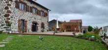
Accommodation in Le Puy-en-Velay.
| Auberge de Jeunesse Pierre Cardinal 14.7€ 50 |
| Gîte d´étape La Colline Aux Cabanes 20€ 20 Booking.com |

|
| Gîte Camping Le Bellevue | |
| Gîte d´étape des Capucins 19€ 19 Booking.com |

|
| Grand Séminaire - Accueil Saint Georges 208 |
| Gîte d´étape Le Relais du Pelerin Saint Jacques Donativo€ 27 |
|
| Gîte d´étape Accueil Saint-François 22*€ 19 |
A scattering of stone houses on the plateau above Le Puy. You'll pass through quickly on a farm track. No services.
The path continues across open farmland on gentle terrain. The volcanic peaks of Le Puy fade behind you as the route follows tracks and minor roads toward Saint-Christophe-sur-Dolaison.
A small agricultural village on the basalt plateau about 8 km from Le Puy. There's a Romanesque church with a squat bell tower and a handful of houses. You may find a water source near the church. Accommodation options are limited; check locally for any gites operating in the area.
From here the GR65 continues southwest across the Velay plateau. The terrain is gently rolling, passing through farmland and scattered hamlets. The path follows a mix of farm tracks and minor roads toward Tallode and Ramourouscle.
A tiny hamlet on the plateau between Saint-Christophe and Ramourouscle. No services. You'll pass through on a farm track without breaking stride.
Accommodation in Tallode.
| Gîte d´étape La Maison Vieille 22€ 14 |
A small hamlet with a notable stone cross dated 1631, classified as a historic monument. No services, but the cross marks a pleasant spot to rest briefly before pressing on toward Montbonnet.
The path continues across the basalt plateau toward Montbonnet, climbing gently through pastureland. The countryside here is open and exposed, with wide views.
Accommodation in Ramourouscle.
| Gîte Lenti-you 25€ 7 |
Sitting at about 1,120 m on the Velay plateau, Montbonnet marks the crossroads of the GR65 and the GR40 (Tour du Velay). It's a natural stopping point roughly 17 km from Le Puy, and many pilgrims end their first day here rather than pushing on to Saint-Privat-d'Allier.
The Chapelle Saint-Roch at the entrance to the hamlet dates from the 13th century and was originally built as a stopover chapel on the Velay roads. It was restored in the 20th century. Accommodation is available at a couple of gites that cater specifically to pilgrims, offering evening meals and breakfast. Book ahead in peak season.
Beyond Montbonnet the landscape begins to change. The path descends gradually through open countryside toward Le Chier and then Saint-Privat-d'Allier. You're leaving the volcanic plateau and approaching the edge of the Allier gorge, though you won't see it yet. The terrain remains gentle, mostly farm tracks and minor roads.
Accommodation in Montbonnet.
| Gîte d´étape La Grange 16€ 15 |
|
| Gîte d´étape l'Escole 39-41**€ 15 |
|
| Gîte la 1ère Étape 14€ 14 |
|
A quiet hamlet on the road between Montbonnet and Saint-Privat-d'Allier. No services. The name means "the dog" in local dialect, though the origin is debated. Press on to Saint-Privat.
The path continues its gradual descent toward Saint-Privat-d'Allier, roughly 4 km ahead. The terrain is easy, following tracks through farmland.
Saint-Privat sits on a basalt promontory overlooking the Allier valley and marks a natural end to the first walking day from Le Puy. It's a proper village with a Romanesque church whose oldest sections date from the 12th century, and the ruins of a medieval castle on the cliff edge above the gorge. Walk to the viewpoint near the castle ruins. The view down into the Allier valley is spectacular and gives you a preview of what's coming.
Several gites and a couple of restaurants serve pilgrims, and you'll find a small grocery or depanneur. The village has a quiet, end-of-the-road feel despite its long history as a stopping point on the pilgrim route.
The castle ruins date from the 13th century. Saint-Privat controlled a strategic position above the Allier crossing and was fortified accordingly. The Romanesque church retains its original 12th-century elements, though it has been modified over the centuries.
From Saint-Privat, the character of the route changes dramatically. You leave the gentle plateau and enter the Gorges de l'Allier. The descent to Monistrol-d'Allier is steep, rocky, and about 350 m of elevation loss over roughly 6 km. It's the first real test of your knees.
The path drops to the hamlet of Rochegude, where there's a small chapel and the ruins of a tower, then descends more steeply through forest toward Pratclaux before plunging down to Monistrol-d'Allier in the gorge bottom. The trail is well-marked but uneven underfoot. Take your time, use your poles, and watch for loose rock.
Accommodation in Saint-Privat-d'Allier.
| Gîte d´étape Le Kompost'l 14-19€ 15 |
|
| Gîte d´étape La Cabourne 40+**€ 53 |
|
| Accueil Pèlerins L’Abri du Jacquet 15.50€ 15 |
|
| Gîte d´étape l'Eau Vive 13€ 7 |
A few houses above the Allier gorge, between Saint-Privat and Rochegude. No services. The path passes through on its way toward the gorge descent.
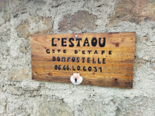
Accommodation in Combriaux.
| Gîte d´étape l'Estaou Dompostelle 35**€ 14 |
|
Rochegude clings to the edge of the Allier gorge at about 967 m, with sweeping views down into the valley. There's a small chapel dedicated to Saint-Jacques and the remains of a medieval tower, the last fragments of a castle that once guarded this stretch of the gorge.
The hamlet marks the beginning of the steep descent toward Monistrol-d'Allier, and it's a good place to pause, adjust your pack, and prepare your knees for what's coming.
The descent from Rochegude toward Monistrol-d'Allier is steep and sustained. You'll drop roughly 370 m through forest. There's a shady, flat section through the trees near Pratclaux that offers brief relief before the path drops again. The surface is uneven, a mix of rocky trail and forest path.
Accommodation in Rochegude.
| Gîte de Rochegude 14€ 14 |
A small hamlet on a shelf in the forest during the descent from Rochegude to Monistrol-d'Allier. It offers a brief flat respite in an otherwise relentless descent. No services.
Below Pratclaux the path continues its steep descent through forest to the floor of the Allier gorge and the bridge into Monistrol-d'Allier.
Accommodation in Pratclaux.
| Gîte d´étape de la Ribeyre 34**€ 12 |
Monistrol-d'Allier sits wedged into the floor of the Allier gorge at about 590 m, the lowest point between Le Puy and Saugues. The village clusters around a bridge over the Allier, one of Europe's last wild rivers, and basalt cliffs rise steeply on both sides. After the long descent from the plateau above, it feels like arriving in a different world.
The village has several gites and chambres d'hotes, a couple of restaurants, and a small shop. The 12th-century Eglise Saint-Pierre has fine polychrome wooden statues in the Auvergne Romanesque style. Look for the Eiffel bridge, a green metal footbridge attributed to the same workshops as the famous tower.
Above the village, the Chapelle de la Madeleine is built into natural caves in the basalt cliff and is worth the short detour if you have the energy. The views back down to the Allier from the chapel are extraordinary.
The climb out of Monistrol toward Saugues is one of the toughest on the entire Via Podiensis. You'll gain roughly 380 m over 6 km of sustained climbing, much of it steep. Start early, take it slowly, and carry water. There are no services between Monistrol and Saugues.
The name derives from "monasteriolum" (small monastery), and there has been a religious community here since at least the 11th century. The Chapelle Notre-Dame d'Estours, on a height above the village, dates from the 12th century and is said to have been built by the same masons who worked on Le Puy's cathedral. It hosts a pilgrimage on the first Sunday of September each year.
The Allier itself has been a migration route for Atlantic salmon since prehistory. Though numbers have dwindled dramatically, salmon still run the river.
Leaving Monistrol, you cross the bridge and begin climbing immediately. The path switchbacks steeply up through basalt scree and forest. The first landmark is the Chapelle de la Madeleine, a troglodyte chapel built into a natural cave in the cliff face, with organ-pipe basalt formations nearby. It's a remarkable site and the views back down into the gorge are worth the pause.
Above the chapel, the trail continues climbing through the hamlet of Escluzels and on up to the plateau. The gradient eventually eases as you reach the farmland above, but the climb is long and unrelenting. Once on the plateau, the terrain gentles into rolling pasture through small hamlets, eventually descending into Saugues.
Accommodation in Monistrol-d’Allier.
| Gîte du Pont Eiffel 15€ 10 |
|
| Gîte d´étape au Ricochet 45**€ 15 |
|
| Gîte et chambre d'hôtes Le Repos du Pèlerin 34**€ 15 |
|
| Gîte d´étape La Tsabone 33**€ 12 |
A tiny hamlet on the steep climb out of Monistrol-d'Allier. You'll pass through gasping and grateful for any excuse to stop. The hamlet sits above the Chapelle de la Madeleine, near the point where the gradient begins to ease. No services.
A hamlet on the plateau above the Allier gorge, between Monistrol and Saugues. The terrain has leveled off by here and the walking is much easier. No services.
Easy walking across farmland and through scattered hamlets. The path follows tracks and minor roads across the plateau toward Le Vernet and eventually Saugues.
A small hamlet on the high ground between Monistrol-d'Allier and Saugues. You're on the open plateau here, with wide views across agricultural land. No services. Saugues is roughly 6 km ahead.
The last hamlet before Saugues. A few stone houses along the path. No services, but you're close now. The path begins a gentle descent toward the town.
A short, easy walk down into Saugues, which you'll see spread across the plateau below.
Saugues is the first proper town you'll reach after Le Puy, and after two days of walking through hamlets with little more than a gite and a water tap, it feels like a metropolis. This small medieval market town sits at about 960 m on the edge of the Margeride plateau and has everything you need: grocery stores, bakeries, restaurants, a pharmacy, ATMs, and a post office.
The town is dominated by the Tour des Anglais, a square 13th-century keep that's the sole survivor of the medieval fortifications. It's named for the English mercenary companies that seized the town during the Hundred Years' War in 1362. At its base sits the Musee Fantastique de la Bete du Gevaudan, a wonderfully eccentric folk-art museum with hand-sculpted dioramas telling the story of the Beast. It's worth an hour of your time.
A statue of the Beast stands in the town center, instantly recognizable, and you'll see its likeness everywhere, on signs, menus, and souvenirs. Saugues has embraced its most famous legend thoroughly.
The Collegiale Saint-Medard is a multi-period church with a 12th-century Romanesque bell tower and porch, a Gothic choir and nave rebuilt in the 15th century, and an octagonal bell tower. Inside you'll find a 12th-century polychrome Virgin in Majesty and the remains of Saint Benilde Romancon, a Christian Brothers teacher who ran a school here from 1841 to 1862 and was canonized in 1967.
The Chapelle des Penitents, built in 1681, houses an 18th-century carved wooden retable and is one of the few remaining penitent chapels built exclusively for that purpose in the department.
Saugues is the last town of any size before Aumont-Aubrac, roughly 60 km to the south. Resupply here. Carry food for the next stretch, as there's nothing between Saugues and the Domaine du Sauvage.
This is your last chance to resupply before a long, remote stretch. There are no food shops between Saugues and the Domaine du Sauvage (roughly 20 km). The Margeride plateau ahead is exposed, sparsely populated, and can be bleak in bad weather. Carry food and plan your water.
Saugues grew under the authority of the Bishops of Mende and the Lords of Mercoeur during the 12th century. The region was heavily fortified, with over 30 castles counted in the wider area by the 14th century.
But Saugues is defined by the Beast of Gevaudan. Between 1764 and 1767, a creature, or creatures, terrorized the former province of Gevaudan, killing around 100 people and injuring nearly 300, mostly women and children. The attacks covered an area of roughly 90 by 80 km centered on the Margeride Mountains, with Saugues itself one of the primary zones of terror. Witnesses described an animal that was "extraordinary and very different from the wolves of this country," tawny with dark stripes, and larger than any wolf.
The attacks became a national sensation. King Louis XV sent professional hunters, including his personal gun-bearer, who killed a large wolf in 1765. The attacks continued. In June 1767, local hunter Jean Chastel shot the beast on the slopes of Mont Mouchet, not far from here. The mystery of what the creature actually was, wolf, hyena, wolf-dog hybrid, or something else, has never been definitively resolved.
Market day is Friday morning. On Holy Thursday evening, the Confraternity of White Penitents, founded in 1652, processes through the streets in hooded robes, barefoot, carrying the instruments of the Passion and chanting the Miserere. It's one of the most striking religious processions in France and draws significant crowds. In early August, the Festival Celte en Gevaudan brings Celtic music to the town.
From Saugues you cross the bridge over the Seuge river and climb gently through fields toward Le Pinet. The path follows a pleasant white track between prairies to La Clauze, at about 1,095 m. From La Clauze to Le Falzet, roughly 2 km, you'll follow a departmental road before returning to footpaths.
You're entering the Margeride, a high granite plateau that stretches for 60 km between 1,200 and 1,500 m. The landscape is austere and beautiful: open pastures bordered by stone walls, patches of forest, scattered granite boulders, and isolated hamlets. It feels remote, and it is. The next settlement of any size is days away.
Accommodation in Saugues.
| Gîte d´étape communal de Saugues 13€ 15 |
| Gîte à la ferme Martins et Itier 39**€ 26 |
|
| Centre d'hébergement La Margeride 20€ 40 |
|
| Gîte d´étape Le Chalet du Pèlerin 32-35**€ 6 |
A small cluster of houses on the path south from Saugues, about 3 km out of town. The terrain is gentle, with the path following a white track between open prairies. No services.
A hamlet at about 1,095 m on the Margeride plateau. You're well into open country now, granite pastureland stretching in every direction. There's a gite d'etape here that provides a stopping option for those who left Saugues late or prefer shorter days. Check availability in advance.
From La Clauze the path follows a departmental road for roughly 2 km to Le Falzet, then returns to footpaths. The terrain is open plateau, easy walking, but exposed to wind and weather.
A handful of stone houses along the road between La Clauze and Chanaleilles. No services. The path returns to footpaths after passing through.
Accommodation in Le Falzet.
| Gîte d´étape Ferme Delcros 16€ 7 |
A small hamlet on the Margeride plateau named for the Lords of Apcher, who controlled much of this territory during the medieval period. The Marquis d'Apcher organized the hunt in which Jean Chastel killed the Beast of Gevaudan in 1767. No services.
Accommodation in Le Villeret-d’Apchier.
| Gîte d´étape Auberge des 2 Pèlerins 16€ 23 |
A quiet farming village on the Margeride plateau where the Seuge river has its source. Chanaleilles sits at the heart of a landscape of granite pastures bordered by dry stone walls and scattered patches of forest. There may be a gite operating here; check locally. The village has a modest Romanesque church.
Chanaleilles gives its name to one of the oldest noble families in the Gevaudan. The village was historically part of the network of hamlets that sustained pilgrims crossing the remote Margeride on their way south.
Accommodation in Chanaleilles.
| Gîte d´étape Le Café du Pont 12-16€ 20 |
A small hamlet on the approach to the Domaine du Sauvage. You're deep in the Margeride now, surrounded by granite and forest. No services.
Accommodation in Chazeaux.
| Accueil chrétien Chez Marie-Aimée Donativo€ 8 |
|
| Gîte de la Virlange 50**€ 8 |
The Domaine du Sauvage is one of the most memorable stops on the entire Via Podiensis. This former monastery and farming estate sits at about 1,292 m in the heart of the Margeride, surrounded by nothing but granite, forest, and sky. It feels like the edge of the world.
The domaine has been welcoming travelers since the 12th century, when it served as a hospitalet for pilgrims crossing this desolate stretch. Today it operates as a gite d'etape and working farm, with about 40 beds and meals prepared from local products. Half-board is the norm. The atmosphere is communal and austere in the best possible way: stone buildings, shared tables, farm animals, and the deep quiet of the high plateau.
Book ahead. This is the only accommodation for a long stretch, and it fills up quickly in season.
There are no services between Saugues and Le Sauvage, roughly 20 km of open plateau. Carry food and water from Saugues. The next services after Le Sauvage are in Saint-Alban-sur-Limagnole, another 14 km south.
The domaine was established in the 12th century as a hospitalet, a shelter for pilgrims on the road to Santiago. It was managed at various times by the Knights Hospitaller and the Hotel-Dieu du Puy. The name "Sauvage" reflects its wild, remote setting rather than any violent history. The estate has been continuously occupied for over 800 years, serving as monastery, farm, and pilgrim shelter through the centuries.
From the Domaine du Sauvage, the path continues south across the Margeride toward Saint-Alban-sur-Limagnole. You'll descend gradually from the high plateau through forest and farmland. The terrain remains remote but the gradient is gentle. The walking is peaceful and solitary.
Accommodation in Domaine du Sauvage.
| Gîte d´étape Le Sauvage en Gévaudan 18€ 41 |