
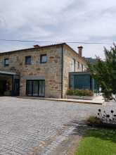
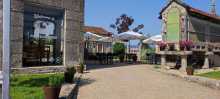
Porto is half the size of Lisbon and twice as rewarding for walking. The city drapes itself across the steep north bank of the Douro, and the historic centre — a UNESCO World Heritage site — earns every bit of its designation. Plan at least one extra day here.
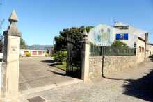
Pick up your credencial at the Se do Porto if you haven't already, or get it stamped if you have. The cathedral, one of the oldest buildings in the city, is Romanesque in origin and fortress-like in character. The cloister's azulejo panels and the terrace views over the rooftops are worth the entrance fee.
The Torre dos Clerigos offers the most commanding 360-degree view of the city — 200 steep steps in a tight spiral. Leave your backpack below. The Igreja do Carmo next to it is unassuming from the outside but spectacular within. Sao Bento railway station, even if you're not catching a train, has an entrance hall covered in 20,000 azulejo tiles depicting Portuguese history — it's one of the most photographed interiors in the country.
The Livraria Lello, often cited as one of the most beautiful bookshops in the world, charges an entrance fee redeemable against a book purchase. The queue can be long. The Cais da Ribeira — the riverside boardwalk — is the social heart of the city, somewhat overpriced but atmospheric.
Three caminos leave Porto: the Central (north through Barcelos and Ponte de Lima to Tui), the Coastal (northwest along the coast through Vigo to Redondela), and the Braga Way (northeast through Braga, rejoining the Central before Santiago). The Central is the most popular and best serviced. The Coastal is growing quickly. The Braga Way has limited infrastructure.
Be aware that arrows in Porto may point to any of these three routes. Follow the Central Way signs heading north from the cathedral.
Before you set off be certain to pick up a pilgrim’s credencial if you have not already done so. It can be found at the Sé Cathedral. This accordion-fold booklet is your passport to the camino and will become your most cherished souvenir of the trip. It is a required document in most pilgrim-specific accommodation, earns you pilgrim prices in many museums, and will serve as proof of your journey when presented to the Pilgrim Office in Santiago if you are planning on getting your Compostela Certificate.As large towns go, Porto is no different when it comes to finding the camino. In fact, it is complicated somewhat by the fact that there are three different caminos between here and Santiago, be aware that you may see signs indicating the ‘Coastal Route’ or the ‘Braga Route,’ or the ‘Central Route’; amongst others.
Porto gave Portugal its name — Portus Cale, the Roman settlement at the mouth of the Douro, evolved into Portucale and eventually Portugal. The city has long valued its independence, earning the nickname Cidade Invicta (The Unvanquished City) after withstanding an 18-month siege by the absolutist King Miguel I in 1832-33. The liberal constitution was preserved, Miguel abdicated, and Porto's resistance became a defining moment of Portuguese political history.
The Port wine trade, controlled by British merchants since the 18th-century Methuen Treaty, shaped the city's economy and architecture. The lodges in Vila Nova de Gaia, the grand houses on the hillside, and the English-style churches all reflect centuries of Anglo-Portuguese commerce.
Between Porto and the border with Spain, the camino splits into three distinct routes. They are known as the Central Way, the Coastal & Litoral Ways, and the Braga Way. Additionally, there are several paths that connect each of these options, creating a network of trails that can sometimes seem confusing. The best plan is to pick one of the options and simply follow it to its natural end.Leaving a large city is often a challenging combination of searching for arrows, heavy traffic, and durable city pavements. As an alternative, it is possible to take the Porto Metro to the city limits or beyond.THE CENTRAL WAYThe Central Way is currently the most popular and well-developed option. As the name implies, the route continues due north from Porto up the center of Portugal. It crosses into Spain at Valença/Tui and continues from there through Redondela to Santiago. THE COASTAL and LITORAL WAYSThe Coastal Way is gaining in popularity as the infrastructure and signage improve. It is sometimes referred to as the Senda Litoral, although this name is technically reserved for the sections of the route that strictly follow the coast. As the primary motivation for choosing the route is the proximity to seaside views, the route set out in this book is a combination of these two routes and the blue line indicated on the map should be interpreted as such. It leaves Porto along the Litoral Route, rather than sharing the first day of walking with the Central Way before turning westward. Where options exist they are indicated on the inset maps. The route passes through Vigo and rejoins the Central Way in Redondela.THE BRAGA WAYSome would consider this the original way, as it passes through the city of Braga where many of the Church's earliest decisions regarding Santiago were made, and where the first Bishop ordained by Santiago (Saint Peter of Braga/Rates) officiated. It was once the capital of Galicia and remains an influential city and massive tourist attraction. These days the infrastructure along the route has not kept pace with the needs of pilgrims and it is seldom traveled. Tours to Braga can be arranged in Barcelos (on the Central Way) if you wish to visit the city. This route is not included in this guide.THE VARIANTE ESPIRITUALThe Variante Espiritual is a popular alternative route north of Pontevedra. It is a two day walk which ends in a 29km boat ride to the town of Pontecesures.
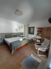
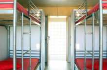
Accommodation in Porto.
| Albergue de peregrinos Porto 20€ 50 |

|
| Spot Hostel 20+€ 42 Booking.com |

|
| The Poets Inn Booking.com |

|
| Gallery Hostel 22*€ 40 Booking.com |

|
| Porto Lounge Hostel 17*€ 26 Booking.com |

|
| Albergue de Peregrinos da Senhora da Hora 13€ 20 |

|
| AHBV Porto Donativo€ 2 |


The sprawl from Porto's centre runs all the way to Giao — 25 km of continuous urban development. This is more than enough walking on hard surfaces, and it's not uncommon for pilgrims to bypass the worst of it by taking the Metro to Araujo (Line C, Linha da Maia).
If you're walking out, the easiest starting point is the Se Cathedral. With your back to the main door, pass the tower on your right and follow the ramp downhill. Turn left then right around the building at the bottom, and look left for stairs leading down to the Igreja de Sao Lourenco (known locally as Grilos). From there, take the leftmost street (Rua de Santa Ana) and follow the arrows through the old city.
The route passes through the pedestrianised shopping zone of Cedofeita before entering suburban sprawl. The split between the Central and Coastal routes occurs at the Capela da Ramada Alta, about 1.5 km beyond the pedestrian zone. Walk around the chapel keeping it on your left and follow the road behind it — the Central Way continues north.
After Giao, the camino has been rerouted to the east along a quieter road, adding 1 km but avoiding a dangerous narrow section on the N306. The detour passes through pleasant countryside and reaches Vairao, where more tranquil walking resumes.
A former parish of Porto, now part of the city centre. The pedestrianised shopping zone here marks the transition from old Porto to suburban sprawl. The Metro Line C (Linha da Maia) offers an escape from the dullest stretches of road ahead.
The Metro of Porto Line C (Linha da Maia) affords an option to walking the most durable part of the camino leaving Porto.
The split between the Central and Coastal (not litoral) routes occurs at the Chapel of the Ramada Alta, a small church roughly 1.5km from where the pedestrian zone ended. Walk around the church, keeping it on your left, and follow the road behind the church. At the fork, turn right. Street signs indicate that you have left Largo Ramada Alta and are now on Rua de Nove de Julio.The road ends at apartments, which you pass under. Cross the road and cross under the apartments opposite as well. Where you emerge from the second set of apartments, turn left.This road (still the Nove de Julio) merges with another. Keep going straight. Eventually, you will pass under the highway. From here there is nothing to do but keep on going straight. You will eventually pass under another highway, where the camino splits into two distinct options.

A hamlet in the suburban sprawl north of Porto. No services on the camino.

The Metro Line C stops here twice — first at the Araujo station, then at the Custio station, which is closer to the camino. This is the practical point to rejoin the route if you took the metro out of Porto.

The Mosteiro de Moreira, a former Augustinian monastery, is the only notable building. The church preserves a Romanesque portal beneath later additions. Turn right at the cemetery entering town — the arrows are painted low on the curb through a sequence of turns.
Entering Moreira, turn right at the cemetery.The camino will take a right-left-right a short distance on, and the arrows are painted low on the curb. Whether you follow them, or you miss them, you will arrive at the main road. Turn right there. A Pingo Doce and a Lidl tell you that you are on the correct road.From here it is a straight road to the Zona Industrial of Maia. Turn left when you get there.
Accommodation in Moreira.
| AirPorto Hostel 22€ 6 Booking.com |

|


An industrial zone. The Metro's Zona Industrial stop is nearby but not on the camino. Pingo Doce and Lidl along the road provide supplies. Turn left when you reach the zone.
The Metro of Porto Line C (Linha da Maia) has a stop called Zona Industrial but it is not along the camino.
Barranha marks a welcome change in scenery. The congestion and noise of Porto are finally behind you, though you're still on paved or cobbled paths. The walking improves from here.

The town itself is a left-hand turn from the camino, which continues straight. A small shop next to the bar. If you need to stay, turn left; otherwise press on through the intersection.
If you wish to spend the night here, turn left. Otherwise, keep on straight through the intersection, passing a few bars on the way out of town.

A small kids' park and a pretty but disused square offer shade for a rest. The church is up the road to your right; the camino passes straight through.


At Giao the camino has been rerouted to avoid a dangerous stretch of the narrow N306. The detour heads east along a quieter road, adding 1 km but improving safety considerably. The route passes through countryside with plenty of bars along the way, and the albergue at Vairao is best reached via this detour. Turn right toward Igreja.
At Gião - Joudina the camino has followed alongside the narrow N306 for about 2km.
The road narrows ahead, and the going was sufficiently dangerous for the camino to be rerouted to the east along a much quieter road. The distance added is 1km, but the route is pretty enough and peaceful enough to feel shorter than along the road.
There are also plenty of bars along the way, and the albergue of Vairão is best reached via the detour as well.
Turn right and head towards Igreja.


Public restrooms next to the church. The camino passes through on the detour between Giao and Vairao.


A hamlet on the road between Igreja and Vairao. No services.

A hamlet on the approach to Vairao. No services.

The Mosteiro de Vairao, a former Benedictine monastery with roots in the 6th century, is the cultural highlight of this detour — and now houses an albergue. The monastery was one of the oldest religious houses in Portugal before the dissolution of 1834.
Shortly before the monastery, the camino turns sharply left. Follow this road 500 m, turn right onto a forest trail, and emerge onto the road to Vilarinho.
Shortly before arriving at the Monastery the camino turns left sharply. Follow that road 500m, and turn right onto a trail through the forest.
Where the forest ends turn right, and at the next big road (N318), turn left again into Vilarinho.
Accommodation in Vairão.
| Albergue de Peregrinos do Mosteiro de Vairão 10€ 60 |

|


A pleasant, shaded square and three albergues to choose from. The camino follows the road out of town toward Fontainhas, keeping left at the fork to leave the busy road before a curve. Old arrows point along the road — they should only be followed if the bridge at Ponte do Ave is impassable.
The camino follows the road out of town in the direction of Fontaínhas and keeps to the left at the fork, leaving the busy road just before a curve. It passes through a small hamlet and then crosses back over the road. Old arrows indicate that the camino continues along the road, but this way should only be followed if the bridge at Ponte do Ave is not passable.
The camino goes straight across the road to a set of stairs that take you down to the river.
Accommodation in Vilarinho.
| Casa da Laura 17*€ 13 |

|
| Casa Família Vidal 20€ 7 |

|


A bridge and small village on the Rio Ave. No services. The camino crosses and continues uphill through a series of well-signed but winding turns to Sao Mamede.
Turn right at the first fork after the bridge. Cross through town and back uphill to the N306, which has wound its way back from where you crossed it last.Turn right on the N306, and then left on the first road. It is well marked with many arrows and a Camino de Santiago information board. If you happen to stay on the N306, you will find more arrows. It is dangerous and noisy, and you are advised to turn back.The camino is clearly marked but anything but straight. Check the direction at every intersection and you will arrive in São Mamede without trouble.

A small village just off the main road. The camino passes through briefly before continuing along a gravel and stone path under the A7 and across the Ponte do Arcos.
The camino leaves the road to pass through this small village and returns to it once past.It continues along the road and under the A7. Here it changes to a gravel and stone path before crossing the Ponte do Arcos.From the bridge, it is a short climb into the village of São Miguel de Arcos.

The camino has been confused here by new arrows along the road — the older path through farmland and forest is better. At the start of town, find the small intersection with a tree in a triangular retaining wall, turn left, and follow the path to Rates. Near the entrance to Sao Pedro de Rates, you cross a railway-turned-pedestrian-path — keep an eye out for arrows pointing west toward Esposende on the Coastal Way.
At the beginning of town the camino is unclear and confused by the presence of new arrows taking you along the road. The way to Rates is better along the old path described below. Likewise, keep an eye out for arrows which take you to Esposende on the Coastal Way, they are near the railway-line-turned-pedestrian-path which you cross over near the entrance to São Pedro de Rates.
At the start of town, you will find a small intersection with a tree set in a triangular retaining wall. Turn left here and follow the curvature of the road to the first fork and turn right. The path takes you through farmland and forest and directly into Rates. An alternate route, which is newer, follows the road.
Accommodation in São Miguel de Arcos.
| Quinta de São Miguel de Arcos Booking.com |

|


The Igreja Romanica de Sao Pedro de Rates sits at the entrance to town and is the finest Romanesque church in Portugal. The church is all that survives of the Benedictine monastery that once stood here — a solemn, heavy-set building whose carved capitals and corbels are worth a careful look. The adjacent museum provides context.
The fountain near the church is attributed to Sao Pedro de Rates himself. Local tradition claims it has miraculous properties — specifically, that it cures sterility in anyone who drinks from it. The water is drinkable regardless of your fertility concerns.
At the start of town the camino splits — keep right for the Central Way. The left fork leads west to the Coastal Way.
At the start of town the camino splits. Keep to your right, following the arrows along The Central Way. The other variation will take you west to join The Coastal Way.
Sao Pedro de Rates is the legendary first Bishop of Braga, said to have been ordained by Santiago himself. The two were contemporaries, and both met the same fate — decapitation. Like Santiago, Pedro's remains were lost for centuries before being rediscovered by means of a miraculous light in the sky, around 800 years later. A church was built to house his relics, which became a pilgrimage destination in their own right.
The historical truth is murkier — Pedro may be a composite figure — but the tradition is deeply embedded in the Camino Portugues and the identity of both Rates and Braga.
Saint Peter of Rates is celebrated on his feast day, the 26th of April.
Accommodation in São Pedro de Rates.
| Albergue de Peregrinos São Pedro de Rates Donativo€ 57 |
| Casa Rural Casa Mattos |
| Casa Anabela | 
|


The sign at the entrance makes the town seem smaller than it is. Pass through the narrow streets and turn left at the main road into the rest of town.
The sign indicating the entrance of Pedra Furada would have you believe that the town is much smaller that it is. Pass through the narrow streets and at the main road turn left into the rest of town. After turning left, keep on the road.
Accommodation in Pedra Furada.
| Albergue O Palhuço 10€ 24 |

|
| Casa da Maria | 
|


A small detour at the start of town bypasses a blind curve in the road. Beyond Goios, the scenery shifts to more businesses and traffic. The camino stays on the road through town, then turns left off it between here and Barcelinhos.
At the start of Góios, a small detour takes you off to the left to bypass a blind curve in the road.
Soon the scenery changes slightly, to more businesses and traffic, even a gas station. The camino stays on the road through this stretch to the end of town. Beyond the edge of town, it turns left off of the road. Between here and Barcelinhos and Barcelos there are services, but the towns are quite small. The most obviously named ones are included here, but there are many more in between them.

A small village between Goios and Carvalhal. No services of note.


Turn left at the church. The camino continues through small villages toward Barcelinhos.
Turn left at the church in Carvalhal.


A small chapel at a crossroads intersection. After passing it, the camino approaches Barcelinhos through a series of road manoeuvres — straight across a roundabout, past a car dealership, through a tunnel under the highway, and up to the N205.
After passing the small chapel in the center of the intersection of Santa Cruz, the camino nears the cities of Barcelinhos and Barcelos and the tangle of roads that encircle them. You will pass straight across a roundabout onto a road adjacent to a car dealership. The road looks like a dead-end but in fact narrows and turns right towards a tunnel underneath the highway. When it emerges, it climbs and winds slightly back up the N205, and turns right. The way into Barcelinhos is straight ahead.

Barcelinhos sits across the Rio Cavado from Barcelos and has grown into a town in its own right. The Igreja de Santa Maria de Barcelinhos is the main building of note. Cross the bridge over the Cavado to enter Barcelos.
Leave town across the bridge over the Río Cávado. At the end of the bridge, turn left (against traffic) and follow the curve in the road up to the church and the ‘palace’.
Accommodation in Barcelinhos.
| Albergue – Residência “Senhor do Galo” 10€ 20 |

|
| Amigos da Montanha 10€ 16 |

|
| Casa das Pombas 20€ 20 Booking.com |
|
| Top'Otel Booking.com |

|

Barcelos is the town of the rooster. The Galo de Barcelos — Portugal's unofficial national symbol — was born from a miracle legend set here: a pilgrim wrongly condemned to hanging declared that the roasted rooster on the judge's dinner plate would stand up and crow to prove his innocence. It did. The oversized, colourful ceramic roosters are everywhere in town, and you'll see them on souvenirs for the rest of the camino.
The ruins at the entrance to town are from the palace of a former Duke, destroyed in the earthquake of 1755 and never rebuilt. The open-air Museo Arqueologico in the ruins is more park than museum, but worth a wander.
The camino through town hits the highlights: the Igreja Matriz opposite the museum; the Torre do Cimo da Vila, which offers the best view of the city and a small crafts exhibition; the Igreja do Senhor Bom Jesus da Cruz, built in 1704 on the spot where a large earthen cross allegedly appeared in 1504; and the Convento de Nossa Senhora do Terco, whose interior is covered wall-to-wall in azulejos with a spectacular wooden ceiling.
The Thursday market in the Campo da Republica is one of the largest open-air markets in Europe — everything from pottery and linens to livestock and farm tools. If your timing aligns, don't miss it. Barcelos ceramics, particularly the black pottery from the nearby town of Prado, are among the finest traditional crafts in Portugal.
All services available. The camino is well marked through town.
The miracle of the rooster has parallel versions in Santo Domingo de la Calzada on the Camino Frances and in Toulouse. All involve a wrongly accused pilgrim, a roasted fowl returning to life, and a hasty pardon. The Barcelos version lacks the explicit Santiago intervention of the Spanish telling but has become the more commercially successful legend — the colourful rooster is now more recognisable internationally than any other Portuguese symbol except the azulejo.
The Feast of the Cross is held on May 3rd at the Igreja do Bom Jesus.
Market every Thursday in the feria space opposite the Igreja.
A fresh set of arrows and signs direct the way through town, past the Igreja Senhor da Cruz and the large market square opposite it (open on Thursdays).
Accommodation in Barcelos.
| Casa do Theatro Guest House Booking.com |
| Albergue Cidade de Barcelos Donativo€ 20 |

|
| In Barcelos Hostel & Guest House 35€ 8 Booking.com |

|
| AHBV Barcelos Donativo€ 4 |


The Council of Vila Boa has installed highly visible yellow signs that guide you through town. After rounding the church, the camino winds through narrow lanes — watch for a cruceiro and wash basin at a fork (keep left) before heading toward the railway crossing into open countryside.
After rounding the church, keep on the road to the first side street and turn right. At the next fork (identifiable for the wash basin and cruceiro) keep to your left. One more right-hand turn and you are heading straight for the railway. At the tracks, the arrows turn left, but that is a not strictly necessary detour to an underpass. You are in the countryside now until Lijó. Turn left at the first fork and into town.
Accommodation in Vila Boa.
| Alojamento Flora 20€ |

|

A small village. A bakery on your left as you pass through. The camino continues past a chapel and park, then begins the steady uphill climb to Portela de Tamel.
The camino passes a convenient bakery on your left as it crosses through town. Pass the front of the chapel and keep to your left, passing another chapel and park not far after. At this point you begin the steady uphill climb to Portela de Tamel, passing along the way intermittent strings of housing.


A village at the top of the climb from Lijo. A church and albergue are along the way. Follow road signs for Quintiaes to the left, then leave the road via a gravel track on your right.
Arrows at the end of town, opposite the ‘Restaurante 2000,’ direct you up the stairs and to your right to pass the church and albergue. They eventually bring you back to the road, which you must follow for about 400m. Follow the road signs for Quintiães to the left, and shortly thereafter leave the road along a gravel track on your right.
Accommodation in Portela de Tamel.
| Casa da Recoleta 5€ 42 |

|

The modern church is unremarkable, but the enormous eucalyptus tree in the open lot beyond it is not — it's one of the largest individual specimens you'll see on the camino. Public restroom next to the church. The ATM, coffee, and shop are to the right (off the camino) after crossing the railway tracks.
Public restroom next to the church. If you are after the ATM, coffee, or the shop, you have to keep RIGHT at the left arrow after crossing the tracks, otherwise see below.
Cross the railway on your right and keep an eye open for the arrows that will take you left shortly after that.The camino turns to track and passes through the countryside, across a stone bridge and eventually to a paved road that leads into Quintiães.
Accommodation in Aborim.
| Casa de Santiago 25€ |

|

A cafe-bakery at the start of town. At the far end, watch for arrows indicating a sharp right turn off the road — often blocked by trucks parked around the farm store. From here it's back to countryside walking, with the Ponte das Tabuas on the way to Balugaes.
At the far end of Quintiães keep an eye out for the arrows that indicate a sharp right-hand turn off the road. It is often blocked by the trucks and traffic parked around the farmer store.From there it is back to the countryside, passing the Ponte das Tabuas on the way to Balugães.

A small stone bridge over a stream with a sandy beach suitable for soaking your feet or taking a quick dip. One of the more pleasant rest stops between Barcelos and Ponte de Lima.

A hillside village where the camino takes the least straight path possible through the streets. At the far end, a small fountain set in a wall marks a fork — turn left to visit the Romanesque church (a climb and detour), or turn right to save the effort and continue along the road.
At the far end of town, where there is a small fountain set in a wall, the camino indicates a left turn. Go that way to visit the Romanesque church, or turn right and save yourself the not-strictly-necessary climb and detour. The camino follows along the paved road until the road turns right to return to the national road; at which point the camino keeps on straight and into the forest. The forest track emerges to a small cluster of homes where you turn right and cross the national road. Follow the narrow road to Lugar do Corgo and beyond.
Accommodation in Balugães.


A small village with one accommodation option — Casa da Fernanda — which is highly recommended as a warm, pilgrim-friendly experience. The camino continues along the narrow road, climbing to Vitorino.
The only accommodation in town, Casa da Fernanda, is highly recommended as a pilgrim friendly experience.
Keep on along the narrow road climbing up to Vitorino.

Turn left at the church and straight through the roundabout. It's uphill from here to Portela.
Turn left at the church, and then keep on straight through the next roundabout to follow the camino uphill.The way to Portela is more uphill.
Accommodation in Vitorino dos Piães.
| Casa da Fernanda 35**€ 10 |

|
| Casa Sagres 23*€ 8 |

|
| Casa Rural O Estábulo de Valinhas 15€ Booking.com |

|

From Portela, the camino rejoins the national road briefly before turning left into a valley through a string of hamlets. The Quinta da Portela is in the first of them.
From Portela, the camino rejoins the national road for a short stretch. Be on the lookout for a turn to your left that takes you into the valley and through a string of hamlets. The Quinta da Portela listed below is in the first of them. You will eventually pass the Quinta do Sobreiro on your left.
Accommodation in Portela.
| Quinta da Portela |

The village is a short distance off the camino — no need to retrace your steps if you choose to spend the night there. A few accommodation options make it practical if the distances work.
Accommodation in Facha.
| Casa Rural Casa das Torres Booking.com |

|

A bar and bakery are along the road where the camino briefly joins it. Shortly after, the route turns left toward the Rio Lima and the Polidesportivo. From here the distinction between towns blurs — hamlets run together along the approach to Ponte de Lima.
The camino joins the road not far past the Quinta do Sobreiro and only for a short while. It is along that stretch that you will find the bar & bakery.When it leaves the road, it does so by turning to the left at a sign which indicates the way to the Rio Lima and the Polidesportivo.Before long you are along a continuous stretch of homes, and the distinction of where one town ends and another begins is a bit vague. Just keep on straight mostly, the only turns are indicated by arrows adjacent to small shrines.
Accommodation in Sobreiro.
| Albergue O Caminheiro 20€ 8 |

|
| Quinta do Sobreiro Booking.com |

|


A hamlet on the continuous stretch of housing approaching Ponte de Lima. No services of note. Keep straight — arrows appear alongside small shrines.


Just beyond Pedrosa, the camino turns left to follow a small river that leads to the Rio Lima. You'll follow it straight into Ponte de Lima, passing under a bridge, past several churches, and along the shaded Avenida 5 de Outubro.
Just beyond Pedrosa, the camino turns left to follow a small river. This small river leads to a big river, the Rio Lima. You will follow it straight into town, passing under a bridge, past several churches, and along the shaded Avenida 5 de Outubro.

Ponte de Lima claims to be the oldest town in Portugal — its royal charter dates to 1125, making it older than the nation itself. The town takes its name from the medieval bridge over the Rio Lima, whose 30 arches span the wide, slow river. The oldest seven arches are Roman, from the 1st century; the rest are medieval, completed in 1370. Your feet won't be able to tell the difference.
The Largo de Camoes is the main square near the head of the bridge — a natural gathering point with cafes and shade. The Igreja Matriz and the defensive towers — the Torre de Sao Paulo and the Torre Cadeia — are all worth seeing. Several churches around town pay tribute in some form to the pilgrimage to Santiago.
Cross the bridge to reach the Parque do Arnado, a beautiful riverside park with gardens along the Lima. The albergue and a toy museum are on the far side.
Ponte de Lima sits at the heart of vinho verde country. The wine is young, slightly fizzy, and best drunk cold — it doesn't travel well, so drink it here. The market alternates Mondays: a larger market on the first and third Mondays, a smaller one on the second and fourth.
All services available.
Ponte de Lima has played host to a very large festival known as ‘As Feiras Novas’ every second weekend in September since 1826. It is a massive party, and if you have not made a reservation long in advance, you may find yourself without a home for the night.
The Romans feared the Rio Lima, believing it to be the Lethe — the river of forgetfulness from Greek mythology. The story goes that the legions under Decimus Junius Brutus refused to cross, fearing they'd lose their memories. Brutus crossed alone, then called each soldier by name from the far bank, proving the water was harmless. The town has celebrated this legend ever since.
As Feiras Novas, the town's festival, has been running since 1826 and is held every second weekend in September. It's three days of feasting, music, and fireworks — book accommodation months in advance or expect to sleep outdoors.
As Ferias Novas, the town festival, is celebrated without pause on the second weekend in September, a three-day feast.
Cross the bridge, passing the museum of toys and the albergue and turn right on the first street. The camino joins a small country lane, passes under the highway, and into Arcozelo.
Accommodation in Ponte de Lima.
| Oldvillage Hostel 22+€ 24 Booking.com |
|
| Albergue de Peregrinos Ponte de Lima 5€ 60 |

|
| Pousada de Juventude Ponte de Lima 20-24€ 50 Booking.com |
|
| Arc My Otel Booking.com |

|


Casa Veiga advertises breakfast from 6 am, just past the church and 100 m on your left. The camino makes a series of well-signed turns before reaching the Ponte da Geira.
The camino makes a series of well-signed turns before arriving at the Ponte do Geira. Cross and keep to your left. You will pass under the highway once, over the river on a new bridge, and then back under the highway twice, all before arriving in Arco.
Accommodation in Arcozelo.
| Noah's Ark Caminho 35**€ 12 |
|

A bridge crossing. The camino continues uphill, passing under the highway multiple times, and over the river on a new bridge before reaching Arco-Revolta.

The camino parallels the road briefly before turning left at the colourful Capilla de Codecal. Directly opposite is a handy bar. From here it's a steady uphill climb past Labruja and Bandeira to the Alto da Portelo.
The camino parallels the road (minor) for a short stretch here, and only turns left when it gets to the colorful Capilla de Codeçal. Immediately opposite the Capilla is a handy and friendly bar. It is a steady uphill climb from here, past Labruja (2.3km) and Bandeira (600m more) and to the Alto da Portela.

A hamlet on the climb from Arco to the alto. No services. Keep climbing.
Accommodation in Labruja.
| Albergue O Conforto 20*€ 8 |

|
| Albergue Casa da Valada 20€ |

|
| B&B Quinta Labruja Booking.com |

|
| Casa do Chafariz | |
| Casa do Olival 35*€ |
|
A hamlet 600 m beyond Labruja. No services. The alto is close.
The alto sits at 400 m — a healthy climb from Ponte de Lima's 5 m. From here it's steadily downhill along parts of the old Roman road, through the small village of Agualonga (no services) and into Sao Roque.
The alto is at 400m elevation, a healthy climb from Ponte de Lima (5m).It is steadily downhill from here along parts of the old Roman road. You will pass through the small town of Agualonga (no services) shortly before São Roque.
A small village on the descent from the Alto da Portelo. No services. The old Roman road surface survives in sections here.
Accommodation in Agualonga.
| Albergue Bota Rota Pilgrim House 17€ 7 |
|
A village with several accommodation options. The Restaurante Constantino, under the same ownership as one of the pensions, provides dinner for most of the lodgings in town. The camino leaves the road for the forest and passes the Romanesque church of Rubiaes and the albergue.
The camino leaves the road for the forest and passes the Romanesque church of Rubiães and the albergue.
Accommodation in São Roque.
| Repouso do Peregrino | 
|


| Albergue Constantino 15€ Booking.com |

|

The Igreja de Sao Joao Baptista de Rubiaes is one of the finest Romanesque churches in the Minho — a compact granite building with carved capitals and corbels that reward close attention. A mini-market in the bar next to the first albergue is closed on Saturdays — plan accordingly.
From the municipal albergue, descend to the road and follow it downhill. Another Roman bridge lies ahead.
From the municipal albergue, descend to the road and follow it downhill and on the left-hand side. You will pass Ninho – The Pilgrim Nest and then dogleg left.Another Roman bridge is not far ahead. Beyond the bridge the camino returns to the road and crossed directly over it, keeping the bar on your right. It will rejoin and depart the road twice more before arriving in Pecene.
Accommodation in Rubiães.
| Albergue de Peregrinos Rubiães 10€ 34 |

|
| Ninho – The Pilgrim Nest 18-20*€ 20 |

|
| Casa de São Sebastião 14€ 18 |

|

A Roman bridge — or rather, a 13th-century bridge on Roman foundations. The reconstruction is solid but the original may have been more elegant. The camino crosses and returns to the road, crossing it twice more before reaching Pecene.
Originally of Roman origin, the bridge you see now is closer to being a 13th century construction.

The church, slightly off the camino, dates from the 13th century and contains a Roman miliario — an original mile marker from the road you've been walking fragments of since Lisbon. The camino passes straight through between the Capela and the Casa de Capela.
Straight through town, passing between the Capela and the Casa de Capela.
Accommodation in Pecene.
| Casa da Capela Booking.com |

|

The Santuario here draws its own pilgrims — a romeria (local pilgrimage) is held on the 11th of July. The arrows in town aren't the best; head to the church, turn left after passing it, and the camino continues through forest trails to Gontumil and Fontoura.
A Romería, or local pilgrimage, is held at the Santuario here on the 11th of July.
The arrows in town are not the best. To get through head to the church and turn left after passing it... after taking a rest in the bosky park in front. The camino keeps to the forest trails through Gontumil to Fontoura.

A hamlet in the forest between Sao Bento and Fontoura. No services.
The camino rejoins a paved road before Fontoura and a larger road through the village. At the far end, it turns left off the road toward Pacos.
The camino rejoins a paved road before Fontoura, and then a larger one as it passes through town. On the far end of town, it turns off this road to the left and towards Paços.
Accommodation in Fontoura.
| PilgerPause 20€ 14 |
| Casa da Quinta do Cruzeiro Booking.com |

|

A hamlet between Fontoura and Valenca. No services.
Accommodation in Paços.
| Albergue Quinta Estrada Romana 20-25*€ 15 Booking.com |

|
A bridge crossing on the approach to Tuido. No services.
Accommodation in Ponte da Pedreira.
| Quinta do Caminho Booking.com |

|
The last village before Valenca. The city sprawl is already apparent and persistent. A few quiet stretches remain, but it's mostly developed from here to the border. The camino crosses the busy N13, follows the Rua da Viega past several churrasqueiras, and turns left at a small chapel toward Arao.
The camino crosses the busy N13 here, following the Rua da Viega past several Churrasqueiras, and turning left at the small chapel. Follow the signs to Arão.


A small village with minimal services. The Casa do Diogo (rooms available) is on your left. Beyond Arao you pass over the railway and into the city limits of Valenca.
Turn right past the Casa do Diogo (on your left, rooms available) and through Arão. There is not much to the town. Soon you will pass over the railway, and into the city limits of Valença. Turn right to follow the road (it is in a poor state for cars but suitable for pilgrims), turning right at the first roundabout and left at the junction shortly after. You are now walking due north towards Spain and directly into Valença.

Valenca is two towns in one. Below the walls is a modern commercial centre, unremarkable. Above, within the massive star-shaped Fortaleza, is a complete walled town — cobbled streets, churches, shops, restaurants, and views across the Rio Minho to Tui in Spain.
The fortress is actually two forts side by side, built in the Vauban style of military architecture that dominated European fortification design in the 17th and 18th centuries. The walls are enormously thick and the layout is designed so that every angle is covered by crossfire from another bastion.
Enter the citadel from its southern door (near the Albergue Sao Teotonio, along the Avenida dos Bombeiros — this approach is recommended). Inside the walls: the Capilla da Misericordia with its polychromatic retablo; the Igreja de Santa Maria dos Anjos; the Igreja da Colegiada de Santo Estevao; a 1st-century Roman miliario; the statue of Sao Teotonio, Portugal's first canonised saint; and the Capilla do Bom Jesus. Walk the perimeter walls for views of the river, Tui's cathedral on the far bank, and the Ponte Internacional connecting the two countries.
The shops inside and around the fortress sell cheap towels, linens, and household goods — a cross-border trade that has attracted Spanish shoppers for decades. The commercial focus can feel at odds with the military grandeur, but there it is.
Leave Valenca through the citadel or along the Avenida de Espanha, crossing the Ponte Internacional into Spain. Change your watch — Spain is one hour ahead.
Change the time on your watch/phone/sundial/wind-up alarm clock. Spain is one hour ahead, so assuming you wake up at the same hour as the day before you will find things to be darker than usual.
When leaving Valença do so by following the signs through the citadel, or along the Avenida de Espanha, crossing the Tui International Bridge (often called the Valença International Bridge, but almost never the Tui Valença International Bridge). The rather quaint building nestled into the bridge on the opposite end is the original checkpoint that has long been out of use.TIP: Cross the bridge using the walkway that is on your right, not the more naturally accessible one on the left. You will have much better views of Tui this way.
Accommodation in Valença.
| Albergue São Teotónio 10€ 49 |

|
| Hostel Bulwark 25-27*€ 17 |

|
| Albergue e AL O Brasão Valença 20€ Booking.com |

|

| Valença Guesthouse 25-27*€ |


Tui deserves at least an afternoon. If you're starting your Camino here, budget an extra night — the old town earns it, and you can always walk across the bridge to Valenca for a wander through the Portuguese fortress.
The Catedral de Santa Maria dominates the hilltop. Built between the 11th and 13th centuries, it's a fortress-cathedral — the crenellated walls and towers were designed for defence as much as worship. The Romanesque-Gothic interior is austere but the cloister and the views over the Rio Mino to Portugal from the grounds are worth the entrance fee. The Museo Diocesano in the cathedral has a small but focused collection.
The route through town passes the most significant monuments: the cathedral, the old Pilgrims Hospital, the Convento de las Clarisas, and the Monasterio de Santo Domingo. The Convento de San Francisco and the Iglesia de San Telmo are slightly off route but close enough to justify a detour.
Cross the bridge using the walkway on the right-hand side — the views of Tui from this angle are much better than from the left. The quaint building at the Portuguese end of the bridge is the original border checkpoint, long out of use.
All services available.
You are advised to get your credential stamped at least twice a day between here and Santiago.
The stretch of camino ahead of you is undergoing changes for the better and keep the camino on a more tranquil and safe path, but there are sections that have become slightly longer, and the directions are not fully set in stone.
This area is one of Galicia’s largest industrial centers, most of the industry centered around O Porriño. In years past this meant a grueling romp through town, just the way that the businesses (read bars) like it. Competing arrows and confusion may ensue; despite the best efforts of local activists.
As usual, a healthy dose of common sense and the use of your best judgment is in order.
In periods of high rain the stretch of road between here and O Porriño is often flooded. In these cases, the camino is temporarily re-routed. When it is, the signs are clear but not frequent and at times it will feel like you just keep walking on the road forever. Stick to the road; the signs will appear when they are needed most.
Tui's position on a hilltop above one of Galicia's most important rivers made it strategic since prehistoric times. The Romans built a settlement on their gold road connecting Braga with Lugo. When the Visigoth King Wittiza left the family stronghold in Toledo in 700 AD, it was to Tui that he relocated — a sign of the town's importance in the late Visigothic kingdom.
San Telmo (Pedro Gonzalez Telmo), patron of sailors, fell ill and died near Tui during his pilgrimage in 1251. His feast day is celebrated on the first Sunday of Easter. There are two historical Saint Telmos — both patrons of sailors — but only one (not this one) has been formally canonised.
San Telmo is celebrated on the first Sunday of Easter.
The camino leaves town just as quickly as it entered it, crosses the N551, and turns right onto the Camino Virgen del Camino at kilometer marker 111.499; a numbers whose significant digits inspires false confidence.
The Louro Valley lies ahead, and the massive granite mining industry situated along it lends a distinctly different feel to the way homes are built compared to only a few kilometers away in Portugal. It is not uncommon to find large slabs of rough granite used to build fences around even the most modest of family plots.
Accommodation in Tui.
| Pensión Raianos Booking.com |
|
| Pensión La Corredera Booking.com |
|
| Pensión O Novo Cabalo Furado ★ Booking.com |

|
| Albergue de Peregrinos Tui 10€ 36 |

|
| Villa San Clemente 15-17€ 22 Booking.com |

|
| Jacob's Hostel Tui 16-18€ 19 Booking.com |

|
| Albergue Ideas Peregrinas 18+€ 12 Booking.com |

|
| Albergue Buen Camino Tui 17*€ 20 Booking.com |

|
| Albergue Convento del Camino 15-17€ 42 Booking.com |

|
| Albergue Pallanes 16€ 20 Booking.com |

|
| Albergue-Hostal San Telmo 12€ |

|
| Hotel A Torre do Xudeu ★★ Booking.com |

|
| Hotel Colón Tuy ★★★ Booking.com |

|
| Hotel Alfonso I ★★★ Booking.com |

|
| Parador de Tui ★★★★ Booking.com |

|


The Capilla here is dedicated to the Virgen del Camino and also houses an image of the Virgen de la Leche — protector of children. The camino turns left at the church and crosses a large highway before following a separated pedestrian section along the road.
The Capilla here is dedicated to the Virgen del Camino, but also has an image of the Virgen de la Leche (yes, milk), the protector of children.
From the church here turn left onto the road and cross the large highway. You will soon begin walking alongside this road, on a pedestrian section that is paved and separated from automotive traffic. Less than 2km from the church you will pass under the highway and very soon after that the camino leaves the road up a dirt track to your right. It is here, at kilometer marker 109.278 that the camino may detour due to high water. Otherwise, it is back over the highway and onto a dirt track into Ribadelouro.

Shortly before arriving here you'll have crossed a very old stone bridge — the modern wood decking disguises its age. Locals call it the Puente de la Fiebre (Bridge of Fever) after San Telmo fell ill and died here during his pilgrimage in 1251. A small church marks the spot.
Pay close attention to the following directions. For several years, and even at the time of publication, the route ahead has been the subject of much trouble.
The bridge earned its name from San Telmo's death during his pilgrimage to Santiago. Pedro Gonzalez Telmo was a Dominican friar who abandoned a life of privilege after a humiliating fall from a horse during a parade — an event he interpreted as divine intervention. He spent the rest of his life preaching to sailors and the poor along the Galician coast before dying here on his way to Santiago.
Accommodation in Ribadelouro.

A confusing junction in an otherwise unremarkable village. At the end of town, the route splits:
Left takes you toward Centeáns and O Porriño along a longer but much more peaceful path through forest and along the river. This riverside route was created by the Galician pilgrim association as a tranquil alternative to the industrial zone.
Right takes you directly to O Porriño through almost 5 km of industrial zone.
Turn left. After the turn, there's another junction where you turn left again — ignore the yellow X marks trying to steer you back to the industrial route. The forest stretch ends at the highway, where you enter Centeáns.
Keep your eyes wide open when passing through Orbenlle. This town is nothing of note but is a very confusing place for pilgrims to find themselves.
The route splits here and depending on who you ask the answer of where to go will differ. The deciding point is at the end of town at a fork in the road. Don’t fret. There are only two ways to go:
LEFT, towards Centeáns and O Porriño along a longer but much more tranquil path. Distances indicated in this guide are for this route. It has been created by the pilgrim association in Galicia as a peaceful alternative to the out of control industrial zone into O Porriño and is often referred to as the riverside walk.
NOTE: After turning left to head into the forest and towards the river, there is another junction where you again have to turn left. There are arrows and the yellow "x" all over the place (designed to steer you back to the industrial zone) but have faith that you will get to the river soon.
The stretch through the forest ends at the highway, where you enter Centeáns.
RIGHT, directly to O Porriño but through an almost 5km stretch of an industrial zone.
The best advice is to turn left; bearing in mind that some arrows and even the locals will tell you to turn right.
Accommodation in Orbenlle.
| Casa Alternativo 38**€ 9 |

|


After the highway, the walk into O Porriño can follow the main road or the river — the split occurs immediately after passing under the highway, with the river route requiring an immediate left turn. Distance is the same either way; the river is preferable.
The walk into O Porriño can be done along the main road, or along the river, and again there are lots of conflicting arrows and warnings painted everywhere. The split occurs immediately after passing under the highway, and the new alternative river route requires an immediate left turn. The distance into town is the same.
O Porriño is the heart of Galicia's granite industry and has been for centuries. The town is functional rather than pretty, but the Palacio Municipal in the centre — designed by local architect Antonio Palacios using the same granite that makes the surrounding hills ring with quarry work — is worth a look.
Basic services. The camino leaves along the N550, crossing a roundabout on the north side of town. After passing under the highway, look right for a tunnel under the off-ramp that leads to Ameirolongo.
Antonio Palacios, born here in 1874, became one of Spain's most prominent architects. His work includes the Palacio de Comunicaciones in Madrid (now the city hall) and numerous buildings across Galicia. The family name appears on buildings and monuments throughout O Porriño.
The camino leaves town along the N550. On the north end of town, you will cross a roundabout, keeping to your right. Soon the road passes under the highway, and the trail leaves the road immediately after. After going under the highway, look to your right for a tunnel that passes under the off-ramp. It will take you to Ameirolongo.
Accommodation in O Porriño.
| Albergue El Cristo 17+€ 42 Booking.com |
|
| Albergue Fonte dos Aloques 17+€ 10 Booking.com |
|
| Alojamiento Camino Portugués 15€ 46 Booking.com |

|
| Albergue Senda Sur 15-17€ 54 Booking.com |

|
| Albergue Camino Santiago Porriño 15€ 28 Booking.com |

|
| Albergue Rincón del Peregrino 15+€ 20 Booking.com |

|
| Albergue Casucho da Peregrina 26*€ 30 Booking.com |

|
| Albergue de Peregrinos O Porriño 10€ 52 |

|
| Pensión Maracaibo | |
| Pensión Puente |
| Hostal Louro |
| Hotel Azul | |
| Hotel Parque |

No services apart from a modest fountain near the basketball court. After the large boulder on your right, arrows may point in conflicting directions — both routes eventually cross the N550 (take extreme care) and climb into the hills.
After passing the large boulder on your right, arrows may indicate keeping on straight or turning left. Both will eventually take you across the N550 (exercise extreme caution) and into the hills. Turning left immediately after the boulder will require less walking along the busy road.
Accommodation in Ameirolongo - Fonte do Chan.
| Albergue SoMos 18+€ 18 Booking.com |
|
A bar-kiosko next to the albergue, but that's the extent of services. The hamlets run together along this stretch of the Louro Valley — the granite quarrying industry that feeds O Porriño's growth is visible in the massive stone walls and fences surrounding even modest houses. If choosing between staying here or in Mos, Mos has more character.
If you have the option of staying in Veigadaña or staying in Mos for the night, the latter is recommended for its charm.
Accommodation in Veigadaña.
| Albergue de Peregrinos Santa Ana de Veigadaña 13€ 8 |

|


Mos is one of the understated pleasures of this stretch. It has everything you need for an overnight stay — a fine church, an albergue, a selection of bars, and the handsome Pazo de Mos — and nothing you don't. Leave town by continuing uphill past the albergue.
Accommodation in Mos.
| Albergue Santa Baia de Mos 10€ 37 |

|

The top of the ascent. The town and hillside take their name from the chapel in the park on the left — a small pre-Romanesque chapel that is one of the oldest surviving structures in the area. The nearest bar is 100 m to your left, off the camino but visible from it. A Roman milestone stands near the road crossing — look for it after crossing.
The camino goes straight across the road and begins the descent into Redondela, passing through Villar and Saxamonde. Keep an eye open for the Roman milestone after crossing the road.
