Ordejon de Ordunte (also called Ordejon de Mena) is a small village where the two branches from Nava de Ordunte and Villasana de Mena converge, near the Taranco chapel. No services. From here the camino heads east toward Espinosa de los Monteros.
Hoz de Mena is a small village at the eastern end of the Valle de Mena. No services. The camino is leaving the broad valley and beginning to enter the foothills of the Merindades.
Concejero is a tiny hamlet between Hoz de Mena and Bercedo. No services. The terrain is gradually gaining elevation as the camino approaches the Merindad de Montija.
Arceo is a small village in the transition between the Valle de Mena and the Merindad de Montija. No services. The landscape is hilly, with oak and beech forests beginning to appear.
Irus is a small village near Bercedo on the approach to the Merindad de Montija. No services. The camino passes through on quiet roads.
Bercedo is a small village on the road to Espinosa de los Monteros. For those who prefer shorter distances, Hotel Rural Valtarranz is about 3 km away in the village of Noceco. The owners are happy to pick pilgrims up in Bercedo or any other reasonable spot.
From Bercedo to Espinosa de los Monteros is flat, sunny, and mostly off-road.
Loma de Montija is a small village in the Merindad de Montija between Bercedo and Espinosa de los Monteros. No services. The terrain is open farmland with the Cantabrian mountains visible ahead.
Accommodation in Loma de Montija.
| Casa Rural Las Merindades Booking.com |
|

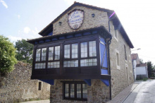
Espinosa de los Monteros is a proper town with services and character. The name refers to the Monteros de Espinosa, a royal bodyguard corps established in the 10th century — the oldest in Europe — whose descendants still serve the Spanish crown ceremonially. The town has a handsome plaza mayor with lively bars and occasional folk dancing.
Hostal Sancho Garcia, recommended by Adolfo, faces the plaza mayor — ask for a room with a balcony for front-row seats to any evening entertainment.
Espinosa has supermarkets, cafes, restaurants, a pharmacy, and an ATM.
The day's walking from Espinosa is almost entirely off-road, through small villages and a beautiful natural area. There's one ascent of about 200 m to a great viewpoint, and a stretch on the Via Verde — an abandoned railway from the never-completed Santander-Mediterranean line, begun in 1879 and halted definitively in 1959.
A shorter alternative through the forest splits at Entrambosrios and is marked.
Accommodation in Espinosa de los Monteros.
| Albergue de Espinosa de los Monteros 8.5€ 82 |
| La Casa Encanto ⭑ Booking.com |
|


| El Montero de Espinosa ⭑⭑⭑ |
Santa Olalla is a small village east of Espinosa de los Monteros. No services. The camino passes through open countryside with the Cantabrian foothills in view.
Para is a tiny hamlet between Espinosa and the Sotoscueva area. No services. The terrain is transitioning from open farmland to forested hills.
Redondo is a small village in the Merindad de Montija. No services. The camino continues through quiet countryside.
Quintanilla del Rebollar is a tiny hamlet near Quisicedo. No services. The landscape is becoming hillier and more forested as you approach the Ojo Guarena karst complex.
Accommodation in Quintanilla del Rebollar.

Quisicedo is a small village in the Merindad de Sotoscueva, notable for being the closest point on the camino to the Ermita de San Bernabe. The ermita is only 2.1 km off-route and is well worth the detour — a 10th-to-12th-century hermitage built into a massive cave entrance that's part of the Ojo Guarena karst complex, the largest cave system in Spain with over 110 km of explored tunnels. Guided tours take about 45 minutes. The setting is spectacular.
No services in the village itself.
Accommodation in Quisicedo.
| Casa Rural Goiko |
Villabascones de Sotoscueva is a small village in the Merindad de Sotoscueva. No services. The camino passes through the forested karst landscape of the Ojo Guarena natural area, with medieval anthropomorphic tombs visible along the route.
Accommodation in Villabascones de Sotoscueva.
| Casa Rural Guareña ⭑⭑⭑ Booking.com |
|
Vallejo de Sotoscueva is a small village in the heart of the Sotoscueva area. No services. The surrounding landscape is characterized by the limestone karst formations and beech forests of the Ojo Guarena complex.
Entrambosrios ("between both rivers") marks the point where the camino offers a split — a forest route provides a shorter alternative to the Via Verde railway path. Both options are marked and rejoin further on. No services.
Accommodation in Entrambosríos.
| Casa Rural La Loma |
Rozas is a tiny hamlet in the transition between the Merindad de Sotoscueva and the Merindad de Valdeporres. No services. The camino continues through green, wooded terrain.
San Martin de Porres is a small village near Pedrosa de Valdeporres. No services. The camino passes through on quiet roads through the Valle de Porres.
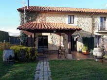
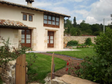
Pedrosa de Valdeporres is the main village in the Valle de Porres. Hotel Rural La Engana offers rooms — a Spanish-British couple runs the facility and also provides English immersion courses.
The highlight near here is the Ojo Guarena natural area. The camino passes through a forested section with medieval anthropomorphic tombs, but the real attraction — the Ermita de San Bernabe — requires a 2.1 km detour from Quisicedo (the previous village). If you haven't made that detour, consider it from here with a short backtrack or taxi.
Pedrosa has a bar and limited services.
The day from Pedrosa is pleasant — nice scenery with one ascent of about 200 m through green tunnels, open field walking, and some road thrown in. Nothing spectacular but very comfortable.
Accommodation in Pedrosa de Valdeporres.
| Casa Rural La Serna |
| Hotel Rural La Engaña ⭑⭑ |
Santelices is about 800 m past Pedrosa de Valdeporres and has an albergue in a former train station on the abandoned Santander-Mediterranean railway line. A convenient alternative to staying in Pedrosa.
San Martin de las Ollas is a tiny hamlet between Pedrosa and Soncillo. No services. The camino passes through on quiet roads through the Valle de Porres.
Argomedo is a small village between the Valdeporres and Bezana areas. No services. The terrain is gently rolling farmland.
Soncillo is a small town that serves as a local center for the Merindad de Valdelucos area. It has a bar and basic services. The town sits at a crossroads in the upper Ebro valley, with the Cantabrian mountains visible in several directions.
Accommodation in Soncillo.
| Albergue Juvenil Soncillo 80 |

| Molino de Luna |
Virtus is a tiny hamlet between Soncillo and the Bezana area. No services. The camino continues through open countryside approaching the Ebro reservoir.
Cilleruelo de Bezana is a small village in the Bezana area south of Soncillo. No services. The terrain is high plateau farmland with views of the surrounding mountains.
Accommodation in Cilleruelo de Bezana.


Herbosa is a tiny village near the Arija area. No services. The landscape is opening up as you approach the Embalse del Ebro (Ebro Reservoir).
San Vicente de Villamezan is a small village near Arija. No services. The camino passes through on the approach to the Ebro Reservoir, which dominates the landscape ahead.
Arija sits on the Embalse del Ebro, a reservoir created by flooding the original town — 400 houses, 8 churches, 2 chapels, and a traditional glass factory were submerged. What remains is an "upper town" built after the dam and a "lower town" by the water. The atmosphere can feel a bit forlorn.
Hotel Rural la Piedra offers rooms. There's a small grocery store down by the water. The albergue appears to be permanently closed.
Arija has limited services — a pharmacy, the hotel, and the grocery store.
Once you leave Arija, you enter Cantabria. The approximately 18 km to Villafria are along the reservoir on the side of a road. The road is very quiet but cars go fast between villages, so stick to the dirt shoulder. About 7 km along, at Villanueva de las Rozas, you'll see the tower of a church that was submerged to create the reservoir — there's a walkway out to it.
After Villafria, the route is mostly off-road. Two highlights: the Roman ruins of Juliobriga (with a museum and church bell tower worth climbing) and, after a 200 m ascent through beech forest to the Pena Cutral, the descent to the Romanesque church of San Pedro de Cervatos with its famous erotic capitals and corbels.

