

You've arrived in Santiago, but the camino doesn't have to end here. Two ancient paths lead west from the Cathedral to the Atlantic coast -- one to Finisterre (the End of the World) and one to Muxia (the sanctuary on the rocks). Most pilgrims walk both, connecting them in a loop. The shared route from Santiago to Olveiroa covers roughly 55 km of quiet Galician countryside, after which the path splits at a roundabout known as The Great Divide.
The walk to the coast is different from everything that came before. There are no pilgrim crowds, the villages are smaller, the services thinner. The terrain is rolling Galician forest and farmland -- eucalyptus, granite, horreos, and the occasional cow. It's a decompression walk, and many pilgrims find it more emotionally satisfying than the arrival in Santiago itself.
Pick up supplies before you leave. The first reliable bar isn't until Alto do Vento, roughly 15 km into the walk.
The Feast day of Saint James is celebrated with a full week of music and dance, with a fireworks display in the Plaza Obradoiro on the evening of the 24th of July. The best views can be had from Obradoiro, or from Alameda park.
The start of the camino to Finisterre is poorly marked, and the fading yellow arrows are hard to find. Fortunately, the way is easy to describe and is very brief; you will be in the forest in less than 1km. Facing the Parador (with the Cathedral to your right) exit the square along the road to your left. It goes downhill along the Rúa da Hortas (named for the gardens which are behind the homes that line this road). The cobbled road ends at an intersection, and here there are several crosswalks, you want the one that takes you over the larger of the roads. The camino follows along the Rúa da Poza de Bar, you can recognize this street for the popular Café Tertulia (perfect for breakfast). It continues straight down this road to a small park at the end, and here the first official marker of the way can be found.It directs you through the park and towards your right, and eventually downhill to cross the river at Ponte Sarela.
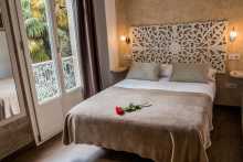
Accommodation in Santiago de Compostela to F & M.
| Albergue O Fogar de Teodomiro 19+€ 24 Booking.com |

|
| Albergue SCQ 21+€ 24 Booking.com |

|
| Albergue SIXTOS no Caminho 18-35€ 40 Booking.com |

|
| KM. 0 26+€ 55 Booking.com |

|
| Blanco Albergue 18+€ 20 Booking.com |

|
| Albergue La Credencial 19+€ 36 Booking.com |

|
| Albergue La Estación 20-30€ 30 Booking.com |
|
| Albergue Porta Real 21+€ 20 Booking.com |

|
| Albergue Meiga Backpackers 16+€ 30 Booking.com |

|
| Albergue Seminario Menor en Santiago de Compostela 17€ 199 Booking.com |

|
| Albergue Mundoalbergue 20+€ 34 Booking.com |

|
| Albergue Santo Santiago 14-18€ 40 Booking.com |

|
| Albergue The Last Stamp 19-25€ 62 Booking.com |

|
| Albergue Azabache 20+€ 20 Booking.com |

|
| Albergue La Estrella de Santiago 15+€ 24 |

|
| Albergue Linares 18+€ 14 Booking.com |

|
| Pensión Casa da Balconada Booking.com |
|
| Pensión Pazo de Argra ★ Booking.com |

|
| Hospedería San Martín Pinario ★ Booking.com |

|
| Albergue-Hotel LoopINN 30+€ 48 Booking.com |

|
| Alameda Rooms Booking.com |

|
| Mapoula PR Boutique Booking.com |

|
| Albergue Fin del Camino 15€ 110 |

|


The remains of an old watermill sit beside the Rio Sarela on the outskirts of Santiago. This is where the city ends and the countryside begins -- a surprisingly quick transition. The stone bridge over the river is your gateway west.

A hamlet on the first climb out of Santiago. Look back for a pleasant view of the Cathedral -- it's the last time you'll see it.
Look back towards Santiago for a pleasant view of the Cathedral.
The camino turns left where it meets the mountain road and follows it for 100m before turning to the right.

The forest meets the road in Moas. When it does, turn right to follow the arrows. A small cluster of houses and not much else.
The forest meets the road again in Moas, and when it does turn right to follow newly installed arrows.

Heavy traffic on the main road here. The route is well marked, but it's common for pilgrims to miss the turn and stay on the road. If that happens, no need to retrace your steps -- keep going to the next road (recognizable by the large stone wall), turn right, then take the next left and you're back on the camino.
Pay attention here. Although the route is well marked, it is still quite common for pilgrims to keep on following the road. If that happens to you, there is no need to retrace your steps. Keep on going to the next road (recognizable for the large stone wall) and turn right, followed by the next left and just like that you are back on the camino.
Turn right at the bus stop / Hórreo.

When you reach the main road of Quintans, the camino turns left and then immediately right again. Watch the arrows carefully.
There's a bar where the camino emerges into town -- the first reliable one since Santiago. The albergue is about halfway through, roughly 400 m off the camino.
The camino crisscrosses the main road through here, following safer side streets where it can. Keep an eye out for yellow arrows near a small bus stop that takes you right. If you miss it, stay on the road -- the camino rejoins it shortly.
The camino crisscrosses the main road and follows safer side streets. Keep an eye out for yellow arrows near a small bus stop that takes you to the right. If you miss it and walk too far, stay on the road and keep an eye out for a yellow arrow that will take you left. If you miss that one, just stay on the road, and the camino will rejoin it very soon.

A small village between Alto do Vento and Aguapesada. The camino passes through without ceremony.
Pharmacy on your right as you pass through. Check out the vines above the bar patio -- they're a combination of grapes and kiwi, a reminder that you're in a climate where both thrive.
Beyond Aguapesada the camino follows a quiet track up into the forest. The climb is fairly steep. The villages between here and Ponte Maceira are small and largely without services -- there's only one bar directly on the route through this stretch.
The road from Ventosa to Aguapesada is straight and along the road. Beyond Aguapesada, it follows a quiet track and road up and into the forest. The climb here is fairly steep. The towns between here and Ponte Maceira are of little note, and there is only one bar directly along this stretch. You will pass Carballo along the way to Trasmonte.

A small hamlet between Aguapesada and Trasmonte. No services along the camino here.

Keep on the road through Trasmonte. A few houses but no services of note.
Keep on the road through Trasmonte.

There's a bar in O Reino, technically a bit off the camino to your left. Useful if the bar in Trasmonte was closed or if you prefer the path less traveled.
Keep on the road through O Reino, and again in 500m through the village of Burgueiros.
The camino passes through Burgueiros on the road without stopping. A hamlet, nothing more.
The medieval bridge over the Rio Tambre is the highlight here, and in summer the river itself draws crowds -- locals and pilgrims wade in to cool off. If you'd rather just rest your feet, there are plenty of spots along the bank.
The one bar/restaurant in town is closed every Wednesday. Plan accordingly.
Cross the bridge and follow the road out of town. The camino parallels the main road from here, crossing and crossing back through the village of Barca. It feels unnecessary, but it keeps you away from traffic. Negreira, the next town with full services, is a few kilometers ahead.
The one bar/restaurant in town is closed every Wednesday.
The translatio legend -- heavily disputed but persistent -- holds that the disciples of Santiago, carrying his body from the Holy Land, were pursued by Roman soldiers. When they crossed this bridge, divine intervention caused the center span to collapse, stranding the Romans on the other side. Others say the miracle happened at a different bridge upstream or downstream. Regardless of geography, the story is recounted on the Negreira coat of arms and has been associated with this bridge for centuries.
Cross over the bridge and follow the road out of town. As is common in these parts, the camino will continue to parallel the main road, crossing and then crossing back through the village of Barca. It feels un-necessary but it keeps you away from the traffic. Negreira is the next city of note and has all of the services you could need.
NOTE: If you intend to stay in the Logrosa Albergue, watch out for signs before entering Negreira. They will take you to the left.


A hamlet on the road between Ponte Maceira and Negreira. The camino passes through.

A small cluster of houses on the approach to Negreira. No services.

Negreira is the first proper town since Santiago and the place to resupply. All services are available -- supermarkets, pharmacy, ATMs, restaurants. The Xunta albergue is on the far end of town, so pick up supplies before you get there if you don't want to walk back.
The Pazo do Coton, a 14th-century tower house near the center, is the most notable building. It now houses the town hall, but the medieval tower is original and gives the town a gravitas its size might not otherwise suggest.
If you're an early-morning walker, scout the route out of town the night before. The camino leaves near the municipal albergue on the west side and passes into dark forest quickly, not emerging until Zas.
"Because I am not inscribed from Noya but from Negreira, where I was born. And from Negreira, which is up the river Tambre, they take you for the army." So says a soldier to his corporal in Ernest Hemingway's For Whom the Bell Tolls.
Hemingway lived for a short time in Santiago de Compostela in 1929, and the impression Galicia made on him was lasting. He referenced it in several novels -- here giving the birthplace to an unnamed character. Some have suggested he also named the protagonist of The Old Man and the Sea after the city, though this remains local lore rather than confirmed fact.
The camino leaves Negreira near the municipal albergue on the West side of town. If you stayed in that albergue, go back towards town a short distance and follow the signs to the church. If you are an early morning (in the dark) walker, do yourself a favor and scout the route the night before. It passes into the dark forest fairly quickly and does not emerge until just before Zas.
Accommodation in Negreira.
| Albergue de Negreira 8€ 8 |
|
| Albergue Turístico de Logrosa 17*€ 20 Booking.com |
|
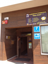
| Albergue Turístico San José 14€ 50 |
|
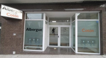
| Albergue Cotón 15€ 40 Booking.com |
|
| Albergue El Carmen 15€ 30 |
|
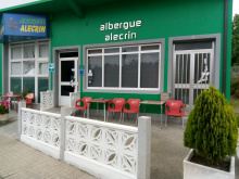
| Albergue Alecrin 15€ 40 |
|
| Albergue Bergando 20€ 60 Booking.com |
|
| Hostal La Mezquita | 
|


There may or may not be a bar open in Zas -- it doubles as a shop for basic necessities but doesn't advertise. Look for it on your left, identifiable by the stacks of empty bottles outside.
You enter Zas along the road but leave at the bar. The town is small, and beyond it the camino follows a pleasant country trail all the way to O Rapote.
You enter Zas along the road, but leave it at the bar mentioned above. The town is small, and you will very quickly find that the camino follows a nice country trail all the way to O Rapote.

Small farming village with a picnic table and fountain at the entrance. Fill your water bottle here.
 on the Camino de Santiago")
An albergue and town bar sit up a flight of steps on your left as you arrive. The village is small but the services are welcome on this stretch.
Accommodation in A Peña and Piaxe.
| Albergue Alto da Pena 17€ 24 Booking.com |
|
| Albergue Rectoral San Mamede da Pena 20€ 22 Booking.com |

|

A hamlet on the road. Much of the camino between here and Vilaserio follows the road, turning left into the forest only at the very end.

If you arrived via the forest trail, turn right to find the bar, the albergues, and the camino. If you missed that turn and stayed on the road, turn left and head into town a short distance.
The bar here is open daily and provides excellent service to pilgrims -- WiFi, clean bathrooms, and a warm welcome. Recommended. The municipal albergue is outside town on the main road.
The camino leaves town along the road. If you stopped at the bar, take the steps down and behind it and turn right then left on the road. You will follow that road all the way to Cornado.
Accommodation in Vilaserío.
| Villa Rica House Booking.com |
|
| Albergue O Rueiro 14€ 30 |
|

There's a fountain in Cornado. The camino leaves the road here and stays off it nearly the entire way to Maronas -- a welcome stretch of forest and trail walking.
The camino leaves the road in Cornado and stays off of it nearly the whole way to Maroñas.

A quiet hamlet on the trail between Cornado and Santa Marina. No services.

The bar and albergue are one and the same. Turn left at the rollo -- the old stone pillar -- to find them. Otherwise continue right past a small picnic area. Be careful on the road beyond here: there's a short but potentially dangerous stretch with traffic.
You will walk along the road here for a short but potentially dangerous stretch. Pay close attention to traffic when crossing.
Accommodation in Santa Mariña.
| Albergue Casa Pepa 17€ 38 |
|

Just a few buildings along the roadside, but with a pair of bars. The camino leaves the road quickly from here and follows smaller country lanes all the way to Ponte Olveiroa -- a particularly scenic stretch through Bo Xesus and A Gueima.
Near Portelinas there's a confusing, poorly marked junction. Some arrows keep you on the road; others indicate a left turn along a gravel road. Both get you where you're going, but the road is half the distance.
The camino leaves the road quickly and follows along smaller country lanes all the way to Ponte Olveiroa. It is a particularly scenic stretch which passes first through the villages of Bo Xesus and A Gueima.
Note: There will come a junction near Porteliñas which is confusing and poorly marked. Some arrows keep you on the road, another set indicates a left turn along a gravel road. Both will get you where you want to go, but the road is half the distance.
Accommodation in Lamelas.
| Albergue Santa Mariña | 
|

A tiny hamlet on the scenic stretch between Lamelas and Ponte Olveiroa. Stone houses, quiet lanes, Galicia at its most unhurried.
Another small hamlet on the country lane approach to Ponte Olveiroa. The walking through here is among the most pleasant on the route.

A hamlet on the trail. If you're interested in the alternate route via A Picota, turn left at the kilometer marker.
If you are interested in the alternate route via A Picota, turn left at the KM 45,146 marker in Vilar do Castro.
The local pool is free for pilgrims -- a rare luxury. This optional detour has proper signage now and rejoins the official camino at Ponte Olveira.
Accommodation in A Picota.
A bar and albergue opened here in 2018, making it possible to divide the route into manageable days without any stretch longer than 26 km. The camino passes through quickly, continuing through the twin hamlets of As Portelinas and As Abeleiroas toward Corzon.
The camino passes quickly through the twin hamlets of As Porteliñas and As Abeleiroas on the way to the church and hamlet of Corzón.
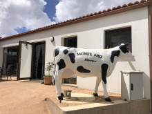
Accommodation in Lago (Mazaricos).
| Albergue Monte Aro 15€ 28 Booking.com |
|

A tiny hamlet on the way to Corzon. No services.

Another small hamlet between Lago and Corzon. The camino passes through without stopping.

A bar and albergue opened here in 2018, adding another option for breaking up the walk. The hamlet centers on its small church.

The bar, restaurant, and albergue are all part of the same operation, on your right after crossing the bridge. A natural stopping point at a pretty river crossing.
Again along the road all the way to Olveiroa.
Accommodation in Ponte Olveira.
| Albergue Ponte Olveira 17€ 20 |
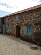
Olveiroa is defined by its horreos -- roughly fifty of them, lining the streets and fields in one of the densest concentrations per capita in Galicia. These granite-and-wood granaries, raised on mushroom-shaped stone pillars to keep out rodents, are the most visible expression of Galician agricultural tradition, and here they comfortably outnumber the human residents.
Two bar/restaurants serve the village. Of the two, As Pias is the recommended choice.
Pay attention leaving town: the camino turns left before reaching the road. This is an easy turn to miss. From here it's mostly uphill all the way through Hospital and beyond, leveling out when you reach The Great Divide.
The camino cuts a straight line through town but NOTE: at the edge of town the camino turns left BEFORE ever getting to the road. This is an easy turn to miss.
It is mostly uphill from here all the way to Hospital and beyond, leveling out only a bit when you get to The Great Divide.
Accommodation in Olveiroa.
| Albergue de Santiago de Olveiroa 10€ 34 |
|
| Albergue Hórreo 17€ 58 |
|
| Albergue Casa Manola 12€ 16 |
|
| Albergue Santa Lucía 12€ 16 Booking.com |
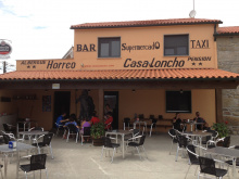
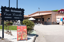
| Pensión Casa Loncho 50*€ |
|
| Pensión As Pías | 
|

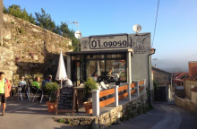
Recently revived by a bar and albergue, Logoso is now a popular stop for those wanting to add or reduce a day of walking. The services are basic but welcome on this otherwise thin stretch.
Accommodation in Logoso.
| O Logoso 15€ 38 Booking.com |
|
The bar here is the last place to stock up on food and water before the paths diverge. If you're heading to Finisterre, there's a fountain between here and Cee but very little else. If you're heading to Muxia, Dumbria has a small shop but it's a good distance ahead. Either way, eat and drink here.
If you are continuing to Finisterre then the bar here is the last place to stock up on water or grab a sandwich. There is a fountain between here and Cee but very little else.
Accommodation in Hospital.
| Albergue O Casteliño 14€ 18 |

|

Shortly after Hospital, in the middle of a large roundabout, a double mojon marks the choice between Finisterre and Muxia. This is where the two routes diverge.
Left takes you to Finisterre -- roughly 30 km, descending dramatically from the highlands to the coast at Cee, then following the shoreline to the end of the world. Right takes you to Muxia -- roughly 30 km through quieter inland territory, arriving at the Atlantic sanctuary from above.
Most pilgrims walk both, either as an out-and-back from Finisterre or as a loop connecting the two. The connecting route between Finisterre and Muxia is roughly 29 km and runs along the Costa da Morte.
From the roundabout with the twin markers, take the paved road to the left and alongside the massive factory. The camino follows the road for 300m before leaving it to join a trail on your right. IF you are headed to Finisterra from this point, all the way to the first building in Cee, the camino remains well isolated from the road and any form of development beyond the two chapels mentioned below.
