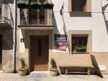
Grañón is the last village in La Rioja on the Camino Francés, and it has earned a reputation far beyond its size. The parish albergue in the Iglesia de San Juan Bautista is one of the most distinctive experiences on the entire route. You sleep in the church itself — mattresses on the floor of the upper gallery, reached by a worn stone spiral staircase. Dinner and breakfast are communal and donation-based, prepared and cleaned up by everyone together. Prayer follows dinner. It's not for everyone, but those who stay here tend to remember it for years.
The church is worth visiting regardless. The 16th-century Baroque retablo is one of the best-preserved in the region, with rich gilding and detailed carving. Of the two monasteries that once served pilgrims in Grañón, only this altarpiece survives.
The village itself is small — fewer than 200 residents — with the solid stone architecture common to these Riojan border towns. A second albergue opened at Carrasquedo, about 1.5 km south in a forest setting, giving pilgrims a quieter option. A couple of bars, a small shop, and an ATM cover the basics. There's a pharmacy in town as well.
Beyond Grañón, the camino crosses into Castilla y León. You'll know — the landscape opens up and the architecture starts to shift.
Grañón's origins are military. The first written reference dates to 885, when "the castle of Grañón was destroyed" — though it was promptly rebuilt. The castle on Mirabel hill formed part of a defensive line against Muslim forces trying to push into Asturian-Leonese territory, alongside nearby fortifications at Pazuengos, Cellórigo, and Bilibio.
From 1044 onward, Santo Domingo began promoting pilgrim traffic along this stretch of the Camino, and Grañón grew accordingly. In 1187 Alfonso VIII granted the town a charter of rights, establishing the legal framework for the settlement that grew up around the pilgrim route.
The town's strategic position on the La Rioja-Castilla border meant it changed hands more than once during the medieval disputes between Navarra and Castilla.
The Fiesta de la Virgen de Carrasquedo falls on March 25, with Mass celebrated in the chapel and open-air dancing. On May 1, the Virgen de Carrasquedo is processed from the chapel to the Iglesia de San Juan Bautista, where she stays through the summer months. San Juan Bautista is celebrated on June 24.
The walk from Grañón to Redecilla del Camino is about 4 km of gentle terrain. Roughly halfway, you cross the regional border from La Rioja into Castilla y León — province of Burgos. There's no grand marker, but the landscape begins to change. The villages ahead are smaller, quieter, and more typically Castilian.
From Redecilla the camino continues through a string of small agricultural villages — Castildelgado, Viloria de Rioja, Villamayor del Río — before reaching Belorado, approximately 18 km from Grañón. Services are scarce between Grañón and Belorado, though most villages have at least a bar.
Accommodation in Grañón.
| La Casa de las Sonrisas 15€ 15 |
|


You've left La Rioja and entered Castilla y León, Spain's largest autonomous community. It's made up of nine provinces; the Camino Francés passes through three of them — Burgos, Palencia, and León. The other six (Ávila, Salamanca, Segovia, Soria, Valladolid, and Zamora) remain off-route but each has its own Camino connections.
The landscape shifts. The vineyards of La Rioja give way to the vast cereal fields of Castile — wheat, barley, and sunflowers stretching to flat horizons. This is the beginning of the meseta, though the true flatness doesn't hit until after Burgos. The villages here are smaller and more spaced out than in Navarra or La Rioja, and services can be thin.
Castilla y León's food is hearty and meat-heavy: morcilla (blood sausage, Burgos-style), lechazo (roast suckling lamb), and cocido castellano are the regional staples. The wines are Ribera del Duero to the south, but along the Camino you'll mostly drink Rioja or whatever the local bar pours.
Redecilla del Camino is the first village in Castilla y León on the Francés, and it makes a good first impression. In the 12th century, two pilgrim hospices operated here — one of them, San Lázaro, lends its name to the current municipal albergue, which has around 50 beds.
The star attraction is inside the Iglesia de Nuestra Señora de la Calle: a Romanesque baptismal font dating to the late 12th century. It's an extraordinary piece of carving — a large stone basin in the shape of a lobed cup, decorated with an intricate representation of a fortified city across four stories, complete with eight semicircular towers, arched windows, and triangular roofs. Most scholars believe it represents the Heavenly Jerusalem, a theme drawn from Jewish tradition that was deeply influential in medieval art. It's considered one of the finest Romanesque baptismal fonts in the province of Burgos, and reason enough to step inside.
The village is small — well under 200 people — but has a bar-restaurant, a small store in the bar, and a tourist information office, which is remarkable for a town this size but easily explained by its location on the route.
Redecilla appears in documents as early as 1028, in the Cartulario de San Millán de la Cogolla. It was once known as Redecilla de los Francos — a nod to the French settlers who came south along the pilgrim route to populate these Castilian towns during the medieval period. This pattern repeated itself across dozens of villages along the Camino Francés, and it's where the route gets its name.
The church was largely rebuilt in the 17th and 18th centuries, but the baptismal font survived from the original Romanesque structure, making it the oldest and most valuable element in the building.
San Roque is celebrated on August 16.
The walk from Redecilla continues through flat agricultural terrain to Castildelgado (2 km), then on to Viloria de Rioja (another 2 km) — birthplace of Santo Domingo. Villamayor del Río follows shortly after. None of these villages has much in the way of services, though Castildelgado has an albergue and a truck-stop restaurant. From Redecilla to Belorado is about 14 km.

A small village with a church, an ermita, and a truck-stop restaurant with a reputation for decent hot chocolate — a combination that sounds unlikely but works. The albergue is the first house you reach coming into town, and the hospitaleros are welcoming.
Not much to detain you otherwise, but the hot chocolate has earned a following.
The town takes its current name from Francisco Delgado López, a native son who served as Bishop of Jaén and Lugo and was one of the most respected Counter-Reformation theologians at the Council of Trent. Before that, the village was known as Villa de Pun.

Viloria de Rioja is best known as the birthplace of Santo Domingo de la Calzada. His house didn't survive the centuries, but the baptismal font where he was christened remains in the parish church — a direct link to the bridge-building saint whose works you crossed days ago.
The Parada Viloria albergue sells sandwiches and drinks. The village is otherwise quiet and agricultural.
Accommodation in Viloria de Rioja.
| Refugio de Peregrinos Acacio y Orietta 15€ 8 Booking.com |

|

Don't let the grand name fool you — neither the village nor its river is remarkable. A handful of houses and a church. No services to speak of. Press on toward Belorado.
Accommodation in Villamayor del Río.
| Albergue Villamayor 15€ 12 |

|

After a long string of small villages, Belorado comes as something of a relief. It's a working town of around 2,000 people at a natural pass between two hillsides, and the geography that made it strategically important still funnels traffic and commerce through its center.
The castle ruins sit on the hillside above town — not much more than foundation walls now, but the position tells you everything about why Belorado mattered. In the cliffs below the castle, caves that served as early Christian hermitages are still visible. San Caprasio and his fellow anchorites Santa Pía and San Valentín reportedly lived here in solitude.
Several churches survive. The Iglesia de Santa María, at the foot of the castle hill, was rebuilt in the 16th century and contains a Gothic carving of the Virgen de la Capilla and a retablo depicting Santiago as both pilgrim and Moorslayer. On the outskirts, the Ermita de Nuestra Señora de Belén was once a pilgrim hospital. The Convento de Nuestra Señora de la Bretonera sits nearby.
The main plaza is a good place to sit and take stock. Multiple albergues operate, along with bars, restaurants, a supermarket, and a pharmacy. Market day is Monday — a tradition dating back to the town's 1116 charter. It may be the oldest continuously held market privilege in Spain.
Belorado has been settled since at least the 4th century BC — a Celtiberian settlement at the site known as La Muela is the earliest evidence. The first documents mentioning the town date to 945, but its real growth began in 1116 when Alfonso I el Batallador repopulated it and granted a charter with market rights and self-governance.
The castle, believed to date from the 9th century, guarded the passage between the kingdoms of Pamplona and the county of Castilla. At its peak, the town had eight churches, a thriving market, and two pilgrim hospices. The caves in the cliffs attracted hermits long before the organized monastic orders arrived — Santo Domingo himself chose hermitage when he was turned away from the monastery of San Millán, and the tradition of solitary contemplation here runs deep.
San Vitores is celebrated on August 26. The Fiestas de Gracias begin on the Thursday before the first Sunday of September, ending on Monday with the Día del Soto. La Virgen de Belén is celebrated on January 25.
A group of traditional dancers — eight members plus the cachibirrio who directs them — performs eight dances during local festivals, some with whistles, others with sticks. The dances have roots in warrior traditions, pastoral life, and trade crafts.
From Belorado, the camino heads west through Tosantos (5 km), Villambistia, and Espinosa del Camino before reaching Villafranca Montes de Oca (about 12 km). The terrain is gently rolling agricultural land, relatively flat. Services thin out quickly after Belorado — Tosantos has a bar and an albergue, but the other villages along this stretch offer very little.
Accommodation in Belorado.
| Albergue de Peregrinos Cuatro Cantones 12-16€ 65 Booking.com |

|
| Hostel.B 22€ 25 Booking.com |

|

| Igloo Rooms Booking.com |

|


Tosantos is tiny — a handful of houses clinging to the camino — but it has grown enough in recent years to support a bar and an albergue parroquial. The albergue maintains a tradition of communal meals and singalongs, the kind of Camino hospitality that makes small villages memorable.
The real draw is the Ermita de la Virgen de la Peña, carved directly into the cliff face just across the creek from the village. You'll see it from the camino — a small stone facade with a Renaissance arch set into the rock, topped by a tiny bell tower. Inside, the cave opens into a chapel that has served as a place of worship for centuries.
The statue of the Virgen de la Peña was hidden here during the 9th-century Muslim advance to protect it from destruction. It now spends half the year in the ermita and the other half in the Iglesia de San Esteban in the village. Ask at the church or the albergue for access — if you're staying overnight, the hospitalero will likely offer a guided visit.
The ermita's origins are medieval. In the 13th century, a hermit lived in these caves and ministered to passing pilgrims, gaining the respect of the local population. The caves themselves show signs of much earlier habitation. According to local tradition, when the Moors advanced on Oca and razed the area, Christians hid a statue of the Virgin under a bell in this cave — its later rediscovery turned the site into a sanctuary.
The Renaissance facade that's visible today was a later addition; the cave chapel behind it is considerably older.
The Fiesta de la Natividad de la Virgen is celebrated on September 8, when the villagers process through town and up to the cliff ermita. It's a small affair but genuine.
The walk from Tosantos to Villafranca Montes de Oca is about 7 km through Villambistia and Espinosa del Camino. Neither village offers much — Espinosa has a bar and an albergue in recent years, but don't count on either being open. Stock up in Belorado or wait for Villafranca.
Accommodation in Tosantos.
| Albergue Parroquial San Francisco de Asís Donativo€ 30 |

|

A tiny hamlet between Tosantos and Espinosa del Camino. No services. The stone houses have a weathered dignity, but there's no reason to stop unless you need to adjust your pack.
Accommodation in Villambistia.
| Albergue de San Roque 15€ 12 Booking.com |

|
Espinosa has seen better days. Even with centuries of passing pilgrims, the village struggles to maintain a presence. In recent years, a few buildings have been rehabilitated into an albergue and a bar, which is more than many villages this size can claim.
The ruins of the Monasterio de San Félix de Oca are nearby — little remains, but the site has early medieval significance as one of the oldest monastic foundations in the region.

Villafranca Montes de Oca sits at the foot of the Pedraja pass, the last outpost before 12 km of forest walking with no water and no services. This is where you fill bottles, buy food, and prepare yourself.
The town straddles the main road, and a pair of bar-restaurants cater to a mixed clientele of pilgrims and truck drivers. The Albergue San Antón Abad, set back from the road at the far end of town, has a large garden and a bar-restaurant that provides a welcome escape from the road noise.
The Iglesia de Santiago anchors the town. It was built on the site of earlier structures and has a Romanesque font worth a glance. The ruins of the Hospital de la Reina, founded in 1380 by Queen Juana Manuel (wife of Enrique II), sit nearby — a reminder of how important this stop was for medieval pilgrims facing the dangerous mountain crossing ahead.
The town's name translates loosely as "free town of the nettle-filled mountains" — fair warning of what awaits on the climb.
From Villafranca there are 12 km of camino without a water supply. There is a source called Mojapán along the route, but its reliability varies. Fill your bottles here and carry enough for the full stretch to San Juan de Ortega.
Villafranca's history is older than its name suggests. It sits on the site of the Roman city of Auca, and from 589 it served as an episcopal seat — the Diocese of Oca, with its first bishop Asterio. That seat held until 1075, when it was moved to Burgos.
The Monasterio de San Félix de Oca, whose ruins lie outside town, dates back at least to 863, when Count Diego Rodríguez Porcelos — the founder of Burgos — donated churches and properties to its monks. The monastery's origins may be even earlier, placing it among the oldest foundations in Castilla.
In the medieval period, the Montes de Oca were feared. The dense forest and confusing paths made ideal terrain for bandits, and the pilgrim guides of the era warned travelers to cross in groups. The establishment of hospices and monasteries along this stretch was a direct response to the danger.
San Antón is celebrated on January 17. A Romería to the Ermita de Oca is held on the second Sunday of August.
The climb out of Villafranca into the Montes de Oca is the first real forest walking since the Pyrenees. Turn right uphill toward the church to follow the camino — don't continue along the main road.
The path gains elevation steadily through oak, pine, and beech woodland. The beginning is steep and should be taken at a measured pace. You'll cross a small ravine at the Carratón river with two steep ramps before continuing through forest.
At the Alto de la Pedraja, there are picnic tables for a rest. En route to the alto you'll pass a monument dedicated to men from Burgos whose bodies were dumped here after execution during the Civil War — a sobering reminder amid the forest quiet.
The path intersects with several ATV trails on the descent. It's well-marked but requires attention at junctions. The dense scrubland was notorious bandit territory in the medieval period, and the pilgrim guides of the era warned walkers accordingly.
San Juan de Ortega lies at the bottom of the descent. There are no shops, but two bars serve food.

The Alto de la Pedraja marks the highest point of the Montes de Oca crossing. Picnic tables at the top offer a rest. The forest continues on both sides.
Along the climb you'll pass a monument to a group of men from Burgos whose bodies were dumped here after their execution during the Spanish Civil War. These roadside memorials appear periodically across northern Spain — quiet reminders of a conflict whose scars are still raw.
The descent from the alto continues through forest toward San Juan de Ortega. The path intersects with ATV trails at several points — follow the yellow arrows carefully. Like the river valleys of Navarra, this dense woodland was once a favorite haunt of bandits preying on pilgrims.

San Juan de Ortega is a monastery, an albergue, and a hamlet of about a dozen houses — and nothing else. There are no shops, but two bars serve meals, and the first one you reach is generally the better of the two.
The monastery church is the reason to be here. It's a fine example of late Romanesque architecture from the 12th and 13th centuries, with three original apses that date from the saint's own lifetime. In the 15th century, Queen Isabella the Catholic commissioned Juan de Colonia — the architect behind much of Burgos Cathedral — to add Gothic arches to the nave. The church has been well restored and is a popular venue for weddings.
Twice a year, at the spring and autumn equinoxes (around March 20 and September 23), a remarkable light phenomenon occurs. At roughly 5pm, sunlight enters through a window in the apse and travels across the nave to illuminate a specific carved capital — the one depicting the Annunciation. As the minutes pass, the light moves to the adjacent capital showing the Nativity. The alignment is deliberate, calculated by the 12th-century builders, and it draws visitors from well beyond the Camino.
The albergue occupies part of the monastery complex. The tradition of garlic soup served to pilgrims continued here for generations — and if you've never shared a dormitory with forty people who've eaten sopa de ajo for dinner, you've missed a defining Camino experience.
Ignore the information board when leaving San Juan de Ortega — it's incorrect and may direct you toward the wrong road. Continue straight on the camino that heads back into the forest toward Agés.
San Juan de Ortega (1080-1163) was born in nearby Quintanaortuño, about 20 km north of here. As a young man, he worked alongside his mentor Santo Domingo, building roads and bridges between Nájera and Burgos to aid pilgrims on their way to Santiago.
After Santo Domingo's death in 1109, Juan went on pilgrimage to Jerusalem. On the return voyage, his ship was caught in a violent storm, and Juan made a vow to San Nicolás de Bari — himself a 4th-century bishop in what is now Turkey, and the historical figure behind Santa Claus. In exchange for his safety, Juan would devote his life to serving pilgrims.
Back in Spain, he chose the Montes de Oca as his base — at the time, the area was notoriously dangerous, thick with bandits and confusing to navigate. He built a hospice here and another in the forest between here and Villafranca. The name Ortega derives from the Spanish for nettle, a reference to the inhospitable terrain he tamed.
The hospice grew into a full monastery and attracted royal attention. Isabella the Catholic placed it under the protection of the Catedral de Burgos and funded significant additions. After centuries of neglect, restoration work has brought much of the stonework back to life.
The communities surrounding San Juan de Ortega hold a romería to the monastery church every June 2, the feast day of the saint. It's a small, local affair with Mass and a procession.
From San Juan de Ortega, the camino continues through forest before emerging at Agés (about 4 km), a small village with albergues and restaurants. Just outside Agés, look for one of San Juan de Ortega's smaller engineering works — a single-span bridge over the diminutive río Vena, likely hidden by tall grass.
From Agés it's another 3 km to Atapuerca, with the terrain gradually opening up as you leave the forest behind.


Agés is a pleasant small village with a quirky mix of albergues and several restaurants that serve meals throughout the day. It's a practical stopping point if San Juan de Ortega was full or if you want to break the distance to Burgos into manageable pieces.
The village has a quiet, lived-in feel that the smaller hamlets along this stretch lack.
Just outside Agés on the left, likely obscured by tall grass, sits a small single-span bridge over the Río Vena — one of San Juan de Ortega's lesser-known engineering works. It takes only one arch to cross the diminutive river.

Atapuerca is a small village of fewer than 200 people, but the caves in the sierra just outside town have rewritten the story of human presence in Europe. Excavations have been underway since the 1970s, and the discoveries keep coming.
The archaeological site itself is a short distance from the village but requires a guided visit — you can't just walk in. Tours are organized from the Centro de Acceso a los Yacimientos in the village, or you can visit the Museo de la Evolución Humana in Burgos, where most of the major finds are now displayed. The museum is one of the best in Spain and well worth the time if you're taking a rest day in Burgos.
The village itself is quiet. A couple of bars, an albergue, and the kind of agricultural calm that makes the prehistoric significance of this spot feel almost surreal. Before you reach the village from the east, you'll pass a large stone marker in the field — the locals call it el fin del rey, marking the spot where King García of Navarra fell in battle against his brother in 1054.
The Sierra de Atapuerca contains one of the most important archaeological sites in the world, designated a UNESCO World Heritage Site in 2000. The key discoveries span an almost unimaginable timeframe.
At the Sima del Elefante, fragments of a jawbone and teeth dated to 1.1-1.2 million years ago represent the earliest evidence of human presence in Western Europe. The Gran Dolina cave yielded the remains of Homo antecessor, a species described in 1997 from bones dating to 800,000 years ago — along with the oldest known evidence of cannibalism among hominids.
The Sima de los Huesos — the Pit of Bones — has produced over 5,500 skeletal fragments from at least 28 individuals of Homo heidelbergensis, around 350,000-400,000 years old. The deliberate placement of bodies in the pit suggests early ritual behavior.
All of this was uncovered almost by accident. In the 1970s, a railway trench cut through the sierra exposed cave deposits that had been sealed for millennia. Systematic excavation began in 1978 and continues today, with new finds regularly pushing back the timeline.
The Battle of Atapuerca, fought here on September 1, 1054, belongs to a different era of history but is no less dramatic. King García Sánchez III of Navarra clashed with his brother Fernando I of Castilla over territory along their shared border. García was killed — some accounts say by his own knight, others by troops who disobeyed Fernando's orders to take him alive. The battle marked the beginning of Navarra's decline as a major Iberian power.
San Martín is celebrated on November 11.
From Atapuerca, the camino climbs into the Sierra de Atapuerca — in reality a modest hill, gaining no more than about 100 m. The views from the top look back toward the Montes de Oca and ahead toward the plains around Burgos. The descent leads to Cardeñuela Riopico and Orbaneja Riopico, neither of which is remarkable, but after Orbaneja you'll face the decision of how to enter Burgos: the river route through Castañares (more pleasant, along the Arlanzón) or the road route through Villafría (longer, industrial). The river route is the strong favorite.
Accommodation in Atapuerca.
| Albergue el Peregrino de Atapuerca 13€ 30 |

|
| Albergue INpulso Atapuerca 20€ 13 Booking.com |

|


The Sierra de Atapuerca is a modest ridge — the climb from the village gains about 100 m and the views from the top stretch across the meseta toward Burgos. On a clear day the spires of the cathedral are visible in the distance. A large cross marks the high point.
The descent on the far side drops through open farmland to the string of small villages — Villalval, Cardeñuela Riopico, Orbaneja Riopico — that precede the approach to Burgos.

A tiny hamlet on the road between the Sierra de Atapuerca and Cardeñuela Riopico. No services. The landscape here is open farmland, and Burgos is beginning to make its presence felt on the horizon.
A small village along the Río Pico with a bar and basic facilities. The Iglesia de Santa Eulalia has some Romanesque elements. It's a functional stop rather than a destination — most pilgrims are focused on reaching Burgos.
Accommodation in Cardeñuela Riopico.
| Albergue Santa Fe 10-12€ 15 |

|
| Albergue municipal La Parada 12€ 12 |

|

Neither Cardeñuela nor Orbaneja Riopico is remarkable for much beyond their position on the approach to Burgos. Pay attention when leaving Orbaneja — shortly outside town you'll face your first decision about how to enter the city. The choice between the river route and the road route matters more than it should.

Less than 1 km after leaving Orbaneja Riopico, the camino splits into two routes into Burgos.
The River Route (via Castañares) is the strong favorite. It follows the Río Arlanzón into the city through parkland and riverside paths — pleasant walking that avoids the worst of the suburban sprawl. Turn left at the split and follow the path to Castañares.
The Road Route (via Villafría) continues straight ahead along the main road through the industrial suburbs. It's direct and well-marked but the walking is dull — asphalt, commercial zones, and traffic. The only advantage is that it passes the airport, which is useful if you're meeting someone.
Take the river route. The yellow arrows can be confusing because local businesses have been known to vandalize or redirect them to divert pilgrim traffic. When in doubt, follow the river.

From Castañares, the river route continues into Burgos along the Río Arlanzón. Finding the path can be tricky — businesses repaint yellow arrows regularly to divert pilgrims toward their establishments. The key: the river route descends toward the river. If you're heading uphill toward the road, you've gone wrong.
Once you find the riverside path, the walking is pleasant — tree-lined, flat, and a world away from the traffic on the road above. The path follows the river all the way into the center of Burgos, passing parks and eventually arriving at the bridges near the cathedral.
A couple of bars in Castañares provide a last stop before the final stretch into the city.

The river route from Castañares into Burgos can be hard to find because the yellow arrows are regularly repainted by local businesses trying to divert foot traffic. The most important thing to remember: the river route goes DOWN toward the river. If arrows are pointing you UP toward the main road, they're misleading you.
Once on the riverside path, follow the Río Arlanzón all the way into the city center. The walking is flat, shaded, and pleasant. You'll pass through several parks before reaching the bridges near Burgos cathedral.
If you end up on the road route instead, don't backtrack — just follow the main road into town. It's less scenic but it gets you there.
Burgos is the first city on the Camino Francés that genuinely demands a rest day — and earns it. Give yourself two nights if you can. There's too much here to rush through, and your body will thank you for the break before the meseta.
The Catedral de Burgos dominates everything. It's a UNESCO World Heritage Site in its own right — one of the great Gothic cathedrals of Europe, begun in 1221 and not completed until 1567. El Cid and his wife Doña Jimena are buried under the central transept. The 15th-century Capilla del Condestable and the starred vaulting of the dome are worth the price of entry alone. Don't miss the Papamoscas, a mechanical clock figure near the entrance that opens its mouth on the hour.
Beyond the cathedral, two monasteries on the outskirts deserve the walk. The Cartuja de Miraflores, about 3 km east of the center, is a working Carthusian monastery whose church contains Gil de Siloé's extraordinary retablo — nearly 100 square meters of carved and gilded wood, completed between 1496 and 1499. The royal tombs of Juan II and Isabel of Portugal, also by Siloé, are among the finest funerary sculptures in Spain. Entry is free.
The Monasterio de Santa María la Real de las Huelgas sits about 1.5 km west of the center. Founded in 1188 by Alfonso VIII and his wife Leonor of Aquitaine, it was a Cistercian nunnery of extraordinary power — its abbess held authority over more than fifty villages and could grant ordination licenses like a bishop. The Royal Pantheon contains Gothic tombs of Castilian royalty. A Moorish war banner captured at the Battle of Las Navas de Tolosa in 1212 is displayed during the annual Curpillos procession.
The Museo de la Evolución Humana houses the finds from Atapuerca and is one of the best museums in Spain — allow at least two hours. The Arco de Santa María, the main gate into the old city from the river, houses a free exhibition hall. The markings on the southern entrance to the Plaza Mayor show historical flood levels of the Arlanzón, with dates.
For eating, the Calle San Lorenzo off the Plaza Mayor has good tapas bars. The Plaza Huerto del Rey leans toward heavier Castilian fare. Burgos is famous for its morcilla — black pudding made with rice — and you'll find it everywhere.
Be wary of misleading signs at the far end of Burgos pointing toward Villalbilla. That town has been cut off from camino traffic by the construction of a rail line, and some efforts have been made to redirect pilgrims there by unofficial means. Follow the official yellow arrows.
Burgos was founded at the end of the 9th century as a military outpost to repopulate the northern plains during the Reconquista. Count Diego Rodríguez Porcelos established the settlement in 884, and within two centuries it had become one of Castilla's most important cities.
The cathedral tells that story. Bishop Mauricio and King Fernando III laid the first stone on July 20, 1221, in the French Gothic style. Construction continued for over three centuries, with major additions in the 15th and 16th centuries — the spires of the main facade, the Capilla del Condestable, and the dome over the transept, completed by Juan de Vallejo in 1567. UNESCO designated it a World Heritage Site in 1984.
Rodrigo Díaz de Vivar — El Cid — was born around 1043 in Vivar, about 10 km north of the city. Raised at the court of Fernando I, he rose to become Castilla's chief military commander before being banished by Alfonso VI for forcing the king to swear an oath of innocence in the death of his brother Sancho II. El Cid went east, carved out his own kingdom in Valencia, and became the most legendary warrior in Spanish history. His remains were moved to the cathedral transept in 1921, after a complicated journey that included theft by Napoleonic soldiers and eventual return from France.
The city's role didn't diminish in later centuries. Fernando and Isabel received Columbus here after his second voyage. And in the 20th century, Franco was proclaimed Generalísimo in Burgos in 1936, using it as his base of operations through the Civil War — a chapter the city doesn't dwell on but hasn't erased.
The fiestas in Burgos run from solemn to spectacular. Semana Santa brings processions through the old city with cofradías carrying elaborate pasos. The Curpillos, celebrated on the Friday after Corpus Christi, is Burgos's most genuinely local festival — a tradition dating to at least 1331, tied to the Monasterio de las Huelgas and the Battle of Las Navas de Tolosa. The procession features Gigantones and Gigantillos (giant figures and their smaller counterparts), traditional dancers, and a military escort carrying a replica of the Navarrese banner. After the morning ceremonies, locals picnic at the Parral meadow near the monastery.
The Sampedros — the festivals of San Pedro and San Pablo around June 29 — are the summer blow-out: a full week of concerts, fireworks, parades, and food stalls. They've been Burgos's main summer fiesta since 1873, moved to late June to guarantee better weather.
San Lesmes, Burgos's patron saint, is celebrated on January 30 with a procession from the Town Hall to the church of San Lesmes, accompanied by the Gigantillos. The traditional San Lesmes rolls are sold by parish youth along the route.
The road out of Burgos is mercifully shorter than the road in. Follow the river west through parkland before the camino turns south toward Tardajos.
This is where the meseta begins — Spain's vast central plateau, stretching ahead for the next 200-odd kilometers through the provinces of Burgos and Palencia. The terrain opens up into endless wheat fields, the sky grows enormous, and the horizons flatten to a thin line. The meseta has a reputation for being boring. It isn't. But it does demand a different kind of attention — to light, weather, the rhythm of your own walking, the subtle changes in a landscape that only reveals itself slowly.
The average elevation here sits around 800 m, and the weather can swing from scorching days to bitterly cold nights. Carry layers.


Tardajos is the first village after Burgos and a common breakfast stop. A few bar-bakeries on the right as you enter serve Torta de Aceite — a type of flatbread made with olive oil that's unique to the area and worth trying. A pharmacy is also on the main road.
The village sits at the intersection of two ancient trade routes, a position that made it more important than its current size suggests. Most pilgrims pass through quickly, but the bakeries alone justify a pause.
Tardajos lies at the junction of two primary ancient roads — the east-west pilgrim route and a north-south commercial road. This crossroads position attracted settlement since Roman times and made the village a strategic point for controlling trade and troop movements across the meseta.
San Isidro Labrador (not to be confused with San Isidoro of León) is celebrated on May 15.
The camino departs the main road in Tardajos — don't be tempted to stay on the asphalt. Cross the street and pass through the village. From here you won't return to a busy road until Frómista. The terrain ahead is flat, open meseta.
Accommodation in Tardajos.
| Albergue La Fábrica 13€ 14 Booking.com |

|

The meseta begins in earnest here, and the landscape tells you everything about the people who built these villages. The lack of naturally durable building material — stone is scarce on the plains — means many traditional structures were built from adobe, and centuries of weather have taken their toll. The treasures that once filled these churches have largely been lost to time and neglect.
Rabé has a couple of bars and a fountain. The village is small but maintains a certain stubborn presence on the plain. The name — 'of the causeways' — hints at the Roman roads that once converged here.
There's a fountain and a picnic area 2.4 km outside Rabé. Beyond that, the camino crosses open meseta — flat wheat fields stretching to every horizon. Hornillos del Camino is about 8 km ahead, hidden in a depression until you're almost on top of it.

A shaded picnic area with a fountain sits about 2.4 km outside Rabé de las Calzadas — the only service point between Rabé and Hornillos del Camino. Fill your water here if you didn't in Rabé.
Hornillos is one of the best-preserved examples of a 'royal road' village: a single long street — the Calle Real — stretched along the camino, with every building facing the pilgrim traffic. This layout allowed each house direct access to the commercial flow that sustained the town. The logic is obvious once you see it.
A pilgrim mass and benediction take place daily at 18:00. Several albergues operate, including a well-run municipal one. A couple of bars serve meals. The village has a self-contained quality that makes it a satisfying stop — everything you need is on one street, and the meseta stretches empty in every direction beyond.
Accommodation in Hornillos del Camino.
| Albergue de Hornillos del Camino 12-15€ 30 |

|
| El Alfar de Rosalía 15€ 24 |

|
| La Casa del Abuelo | 
|

The spring at the Arroyo San Bol (literally 'Saint Bol's Creek') is reputed to cure sore feet — whether this is folk medicine or placebo effect, soaking them in the cold water certainly helps. A small albergue operates here, converted from what was once something of a hippie hideaway before being taken over and modernized by a nearby municipality.
The short detour from the camino is clearly marked. It's a peaceful spot in a landscape that can feel overwhelmingly open.
Don't let the endless wheat worry you. Hontanas stays hidden from view until you're almost on top of it — the village sits in a small depression that's invisible from a distance on the flat meseta.
Accommodation in Arroyo San Bol.
| Albergue Arroyo de San Bol 10€ 12 |

|


Hontanas takes its name from the fontanas (natural springs) that dot the area. The springs still pour day and night, feeding fountains around the village. In summer, the local pool does most of the refreshing.
The village appears suddenly — sunk into a small fold in the meseta, it's invisible until you're nearly there. It's a welcome sight after the long, exposed walk from Hornillos. Several albergues, a couple of bars, and a small shop provide services. The atmosphere is generally friendly and unhurried.
San Roque is celebrated on August 16.
Accommodation in Hontanas.
| Mesón Albergue El Puntido 15€ 40 Booking.com |

|
| Albergue Santa Brígida 15€ 42 Booking.com |

|
| Albergue Fuente Sidres 20€ 17 |

|


The ruins of the Convento de San Antón are one of the meseta's finest surprises. The remains of the monastery arch over the camino itself, and you walk through what was once a grand pilgrim hospital. The Antonine monks who ran the order specialized in treating ergotism — a disease caused by contaminated grain that was common in medieval Europe. They wore a distinctive Tau cross, which you'll see carved into the stonework.
The ruins are atmospheric and photogenic. A small albergue has been established in the remaining structures, offering a donativo bed in a genuinely historic setting. Even if you're not staying, pause here — the combination of the arch, the ruined walls, and the open meseta beyond makes this one of the most memorable spots on the Francés.
Accommodation in San Antón - Les ruines.
| Albergue de San Antón Donativo€ 12 |

|


Castrojeriz is deceptively long — the camino follows the Calle Oriente through a town that seems to go on forever. Don't rush it. Three churches, a ruined castle, and a tunnel system connecting the cellars beneath the main street all reward a slower pace.
The Colegiata de Santa María del Manzano has a 13th-century Black Madonna. The Iglesia de Santo Domingo houses a tapestry museum. The Iglesia de San Juan, at the far end, has a beautiful cloister. All three are worth seeing.
The castle ruins on the hilltop above town provide the best view of the meseta you'll get from any direction — the climb is short but steep. From the top you can see the route ahead stretching west toward the Alto de Mostelares and, on a clear day, well into Palencia.
Several albergues, bars, and restaurants line the main street. A couple of small shops handle provisions. The town has more character than its size suggests — the length of the Calle Oriente and the quality of its buildings speak to medieval prosperity that the surrounding farmland no longer supports.
Beneath the main street runs a tunnel system connecting the cellars of the houses on both sides. It was used for storage and, in times of trouble, as an escape route. The castle above dates to the Visigothic period and was rebuilt repeatedly by Moorish and Christian rulers. The town received its charter in the 10th century.
San Juan is celebrated on June 24. Santa Catalina on November 25-26.
The road ahead climbs to the Alto de Mostelares — the highest point on the meseta section. There's little shade between here and the crossing into Palencia.
Accommodation in Castrojeriz.
| Albergue de San Esteban 7€ 30 |

|
| Albergue and Camping de Castrojeriz 7€ 35 |

|
| Albergue Ultreia 16€ 26 |

|
| Albergue Rosalía 15€ 32 Booking.com |

|
| Espacio Interior 15€ 7 |

|


The Alto de Mostelares is the highest point on the meseta section, though the climb from Castrojeriz is less daunting than it looks from below. The first stretch is steep, but it levels off quickly. From the top, the view looking back toward Castrojeriz and the plain beyond is more impressive than what lies ahead.
A shelter at the summit provides shade. The descent on the far side is steep at first, then eases as you approach the shaded picnic area before the Ermita de San Nicolás.
The descent from the alto follows a resurfaced track, steep at first then gentler. Between the alto and the Ermita de San Nicolás there's a shaded picnic area — the only real shade on this stretch.